Current situation of #GPS jamming on a #map
https://gpsjam.org/?lat=46.18507&lon=44.58297&z=3.1&date=2025-06-22
Current situation of #GPS jamming on a #map
https://gpsjam.org/?lat=46.18507&lon=44.58297&z=3.1&date=2025-06-22
Question folks... actually questions.
There are numerous incidents like this one where airplanes get into troubles allegedly because of the GPS jamming, again allegedly, by Russia.
I am not so deep into aircrafts, nor GPS or wide scale jamming (it's set of satellites if I'm not mistaken, right?)
So is there anyone to explain how this can be done?
#question #airport #aircraft #airline #gps #gpsjam #russia #russianwar #russianinvasion #schwechat #brno
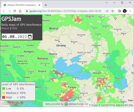
There is actually a website dedicated to GPS jamming:
https://gpsjam.org/?lat=48.16150&lon=45.60653&z=6.3&date=2024-12-28
This confirms that the artifacts are probably a result of GPS jamming.
Как джамминг и спуфинг GPS мешают мирному населению
Региональная карта помех GPS на 5 августа 2024 года, источник Давно известно, что сигнал GPS подвержен джаммингу (глушению) и спуфингу (подделке). Орбита спутников находится на высоте 20 180 км, так что сигнал на Земле легко заглушить. Но вот спуфинг считали слишком сложным и дорогостоящим. Сейчас всё изменилось. В наше время энтузиаст-любитель с парой сотней долларов и инструкциями на Github может подделать сигнал GPS. Правительства тоже стали активно искажать сигналы систем навигации в рамках электронных войн. Спуфинг перешёл из теоретических научных статей в реальную жизнь. К сожалению, помехи GPS распространяются далеко за пределы зон военных конфликтов, что влияет на повседневную жизнь простых людей в Москве и Санкт-Петербурге, Латвии, Эстонии, Финляндии, Беларуси, Турции и др. (на КДПВ).
https://habr.com/ru/companies/ruvds/articles/834418/
#GPS #джамминг #спуфинг #глушилки_GPS #геопозиционирование #навигатор #БПЛА #радиоблокираторы #ГЛОНАСС #Beidou #ЛПД801 #Дрон1200 #SandboxAQ #AQNav #квантовые_сенсоры #магнитное_поле_земной_коры #геомагнитная_навигация #Dassault_Falcon #Gulfstream #Bombardier #GPSJam #электронная_война #meaconing #ГНСС #GNSS #ruvds_статьи

John Wiseman, an open-source software developer specializing in aviation and aircraft tracking, reveals hidden aspects of our world. Join his mission of enhancing government transparency and empowering exploration. Discover his projects like GPSJAM, the Advisory Circular network, and more.