The Feasibility Of Using LiDAR-Derived Digital Elevation Models [DEMs] For Gravity Data Reduction
--
https://www.usgs.gov/3d-elevation-program/news/feasibility-using-lidar-derived-digital-elevation-models-gravity-data <-- shared article
--
https://pubs.usgs.gov/publication/ofr20251019 <-- shared report
--
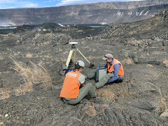
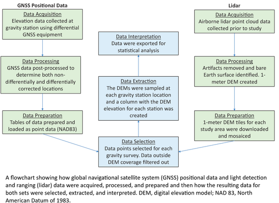
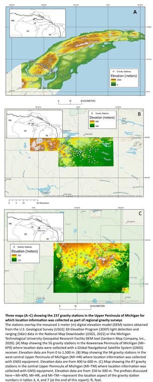
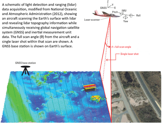
“A nice report from our colleagues in the USGS Mineral Resources Program on the feasibility of lidar-derived DEMs, including 3DEP data, for gravity data reduction…”
#GIS #spatial #mapping #3dep #elevation #fedscience #remotesensing #earthobservation #gravity #submetre #accuracy #precision #dGNSS #GNSS #global #navigation #satellite #GPS #LiDAR #DEMs #gravimetrics #milligals #Bouguer #anomaly #monitoring #corrleation #refinement #datareduction #appliedscience #usecases
@USGS
The Feasibility of Using Lidar-Derived Digital Elevation Models for Gravity Data Reduction

Learn about the Feasibility of Using Lidar-Derived Digital Elevation Models for Gravity Data Reduction

USGS
I find it comical that Google has a new AI Cybersecurity initiative. "Don't collect unnecessary heaps of data." is probably the best cybersecurity strategy for Google. Yet, it is also the one they won't take.
https://technologymagazine.com/articles/google-announces-initiative-to-boost-cybersecurity-using-ai
#cybersecurity #AI #datareduction
Google Announces Initiative to Boost Cybersecurity using AI

Google's new AI Cyber Defense Initiative aims to help digital defenders gain the upper hand over attackers and, in turn, boost global security

This would be a few settings, you could configure. It would be all stored locally in your browser and would never leave your computer

#Privacy #DataReduction #DataEconomy #amProgramming #amCoding #amWriting #WritingCommunity #FLOSS
#FOSS #OSS #IndieWeb #Fediverse #ZuriCode #MastodonWritingChallenges

#LightCurve for #exoplanet WASP-12 b, with data obtained on January 4th, 2023, using the MicroObservatory (references at the bottom of the picture).

#astronomy #astronomia #DataReduction

Incredible what expertise in #ImageProcessing, #DataReduction, and #SoftwareDevelopment can get you.

Recognise the initial #JWST image on the left? Check out the faint light in the newly processed image on the right, created by @aaron and the #ICRAR JWST team!

Read more (and hear from @aaron himself!) on the benefits of really meticulous sky subtraction: https://www.icrar.org/icrar-enhances-jwst-imaging/
Taking the James Webb Space Telescope's images to the next level - ICRAR

Researchers at the International Centre for Radio Astronomy Research (ICRAR) have released a spectacular new render of the first James Webb Space Telescope (JWST) image. Utilising specialised software, the new image shows the incredible capabilities of the JWST and the how deeply it can search the universe.

ICRAR
We recently tested out the idea of doing #microlensing from #space using the #NASA #Kepler #telescope. Kepler has so far found thousands of #exoplanets but using the #TransitMethod, not microlensing. But in 2016, before it stopped working, it did a mini microlensing survey. Kepler wasn't designed to do microlensing and colleagues spent years developing a #DataReduction pipeline that would work. Then, my #postdoc Iain McDonald and I built a sophisticated pipeline to find #planet candidates (6/n)