A Comprehensive Framework For Evaluating The Quality Of Street View Imagery
--
https://doi.org/10.1016/j.jag.2022.103094 <-- shared paper
--
“HIGHLIGHTS
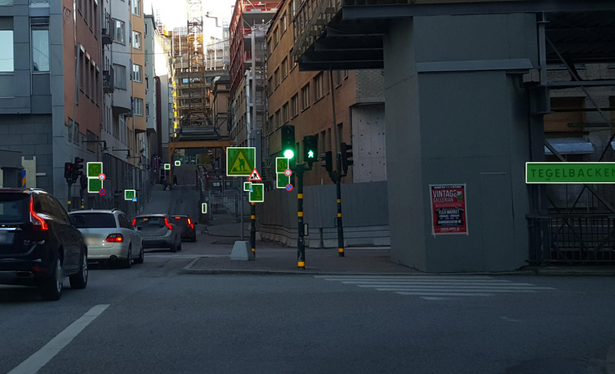
• [They] propose the first comprehensive quality framework for street view imagery.
• Framework comprises 48 quality elements and may be applied to other image datasets.
• [They] implement partial evaluation for data in 9 cities, exposing varying quality.
• The implementation is released open-source and can be applied to other locations.
• [They] provide an overdue definition of street view imagery..."
#GIS #spatial #mapping #streetlevelimagery #Crowdsourcing #QualityAssessmentFramework #Heterogeneity #imagery #dataquality #metrics #QA #urban #cities #remotesensing #spatialanalysis #StreetView #Google #Mapillary #KartaView #commercial #crowsourced #opendata #consistency #standards #specifications #metadata #accuracy #precision #spatiotemporal #terrestrial #assessment
--
https://doi.org/10.1016/j.jag.2022.103094 <-- shared paper
--
“HIGHLIGHTS
• [They] propose the first comprehensive quality framework for street view imagery.
• Framework comprises 48 quality elements and may be applied to other image datasets.
• [They] implement partial evaluation for data in 9 cities, exposing varying quality.
• The implementation is released open-source and can be applied to other locations.
• [They] provide an overdue definition of street view imagery..."
#GIS #spatial #mapping #streetlevelimagery #Crowdsourcing #QualityAssessmentFramework #Heterogeneity #imagery #dataquality #metrics #QA #urban #cities #remotesensing #spatialanalysis #StreetView #Google #Mapillary #KartaView #commercial #crowsourced #opendata #consistency #standards #specifications #metadata #accuracy #precision #spatiotemporal #terrestrial #assessment