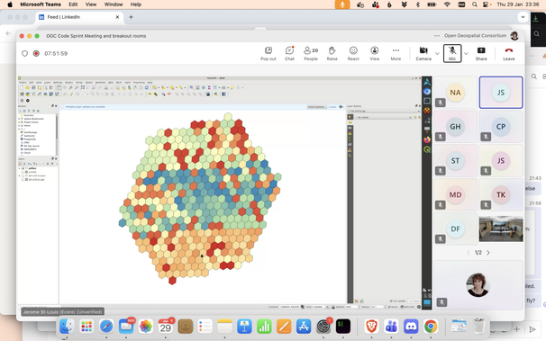
And the last demo, from Jerome St-Louis, takes us to a #ML model running over a #DGGS grid #codesprint27
A demo showing streaming of very large tiled images over the network #codesprint27 #heif #C
Joan Maso and Nuria Julia demonstrate an #OGCAPI maps client displaying HEIF files #codesprint27 #javascript #demo
Support to OGC API PubSub was added to @pygeoapi during #codesprint27 🚀 Thank You @tomkralidis 👋 https://github.com/geopython/pygeoapi/pull/2220 #metadata #notifications #mqtt
@tomkralidis presents a #pygeoapi plugin to publish HEIF files as #OGCAPI maps #codesprint27 #demo

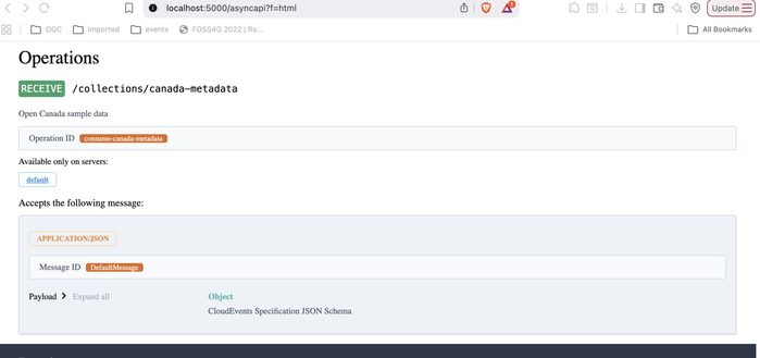
Did you ever imagine getting notified for a change in a record or feature collection? That is possible with OGC API - Publish Subscribe #MQTT #OGCAPI #codesprint27

https://github.com/opengeospatial/pubsub

Joan Maso explains the beneits of the HEIF format for storing images #mentorstream #codesprint27 #sprint #tutorial #standards
OSHConect - lowering the barrier to access OGC API - Connected Systems; tutorial from Robin White at the #mentorstream of #codesprint27 #ogcapi #standards #ogc #observations
"Why do we want to use datacubes"? Peter Bauman gives some background on coverages in his tutorial at the #mentorstream of #codesprint27 #rasdaman #standards #OGC
@tomkralidis shows how these components are available as #FOSS @osgeo softtware #codesprint27 #mentorstream @pygeoapi @qgis