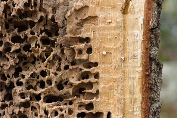
This satellite view was taken yesterday, 2/10/26, showing eastern #Massachusetts and the islands of #MarthasVineyard and #Nantucket The #ElizabethIslands stretch across Buzzards Bay from the Cape. My town, #Fairhaven, is on #BuzzardsBay, between Cape Cod and #RhodeIsland A lot of our harbors are iced over.

#CapeCod #Snow

Looking East at Sunset
Mark's Cove, Wareham, Massachusetts, United States

Taken on 2022-02-06 16:59:07 with Fuji 10-24mm F4 on Fuji X-T4 with exposure 1/35s @ f/10 @ 10mm @ 160 ISO

Photo location: https://www.openstreetmap.org/#map=17/41.7365457083333/-70.731403135

Critiques welcome. Thanks for taking the time to look at my photo.

#Photography #AmateurPhotography #MyPhoto #HandHeld #Clouds #LandscapePhotography #Ocean #OceanWednesday #MeerMittwoch #Saltmarsh #SeascapePhotography #Sky #Sunset #WaterOnWednesday #Weather #Winter #FujiFilm #FujiXSeries #FujiPhotography #BuzzardsBay #Massachusetts #PhotoCritique

Hype for the Future 66E: Upper Cape

Introduction The Upper Cape region of Barnstable County, Massachusetts, consists of the four westernmost towns in the county: Mashpee, Falmouth, Sandwich, and Bourne. The Towns of Mashpee and Falmouth have shores on the Nantucket Sound, with Falmouth also containing a southwestern shore on the Vineyard Sound and a western shore on Buzzards Bay. Of the four towns, only Sandwich contains a shoreline on the Cape Cod Bay, though the Town of Bourne contains a shoreline further into Buzzards Bay […]

https://novatopflex.wordpress.com/2026/01/05/hype-for-the-future-66e-upper-cape/

Hype for the Future 66E: Upper Cape

Introduction The Upper Cape region of Barnstable County, Massachusetts, consists of the four westernmost towns in the county: Mashpee, Falmouth, Sandwich, and Bourne. The Towns of Mashpee and Falmo…

novaTopFlex

Hype for the Future 65C: Martha’s Vineyard, the Island of Dukes County

Introduction While the Elizabeth Islands that separate the Buzzards Bay from the Vineyard Sound are located off the coast of the Woods Hole area and contain the Town of Gosnold, the vast majority of the approximately seventy (70) permanent residents are exclusively within the area of the village of Cuttyhunk on Cuttyhunk Island specifically, as the remaining islands are largely identified as privately owned by the Boston Brahmin Forbes family. The vast majority of Dukes County, […]

https://novatopflex.wordpress.com/2026/01/04/hype-for-the-future-65c-marthas-vineyard-the-island-of-dukes-county/

Hype for the Future 65C: Martha’s Vineyard, the Island of Dukes County

Introduction While the Elizabeth Islands that separate the Buzzards Bay from the Vineyard Sound are located off the coast of the Woods Hole area and contain the Town of Gosnold, the vast majority o…

novaTopFlex

1200-ton railroad bridge over Cape Cod canal, Buzzard's Bay, Mass. [ca. 1910]

1 photographic print. | Drawbridge.

The Cape Cod Canal is an artificial waterway in Massachusetts connecting Cape Cod Bay in the north to Buzzards Bay in the south, and is part of the Atlantic Intracoastal Waterway. The approximately 7.4-mile-long (11.9 km) canal traverses the neck of land joining Cape Cod to the state's mainland. It mostly follows tidal rivers widened to 480 feet (150 m) and deepened to 32 feet (9.8 m) at mean low water, shaving up to 135 miles (217 km) off the journey around the cape for its approximately 14,000 annual users.

#railroadbridge #CapeCodcanal #BuzzardsBay #bridge #railroad #CapeCod #drawbridge #Mass
https://www.loc.gov/item/2003678310/

On the Horizon 25C: The Town of Gosnold, Massachusetts

The Town of Gosnold, Massachusetts, is located on the Elizabeth Islands, all of which are claimed by Dukes County, and all but two of which are also claimed by the Boston Brahmins by way of the Forbes family. Cuttyhunk Island is home to the vast majority of the approximately seventy people of the Town of Gosnold, the smallest of the towns of Massachusetts.

Evening Storm Clouds - Raining and cloudy on and off all day lead to good oportunities for storm cloud reflections.
12 shot vertical pano
Mark's Cove, Wareham, Massachusetts, United States

Taken on 2023-10-16 17:19:13 with Fuji 10-24mm F4 on Fuji X-T4 with exposure 1/50s @ f/10 @ 10mm @ 200 ISO

Photo location: https://www.openstreetmap.org/#map=17/41.7365641666667/-70.731408055

Critiques welcome. Thanks for taking the time to look at my photo.

#Photography #AmateurPhotography #MyPhoto #Clouds #Fall #HandHeld #LandscapePhotography #Ocean #OceanWednesday #MeerMittwoch #Reflection #Saltmarsh #Sky #WaterOnWednesday #Weather #FujiFilm #FujiXSeries #FujiPhotography #BuzzardsBay #Massachusetts #PhotoCritique
Dusk on Mark's Cove
Mark's Cove, Wareham, Massachusetts, United States

Taken on 2025-11-02 16:46:54 with Fuji 16-55mm F2.8 on Fuji X-H2 with exposure 1/7s @ f/8 @ 16mm @ 400 ISO

Photo location: https://www.openstreetmap.org/#map=17/41.736501945/-70.731280555

Critiques welcome. Thanks for taking the time to look at my photo.

#Photography #AmateurPhotography #MyPhoto #HandHeld #LandscapePhotography #Ocean #Reflection #Saltmarsh #Sky #Sunset #FujiFilm #FujiXSeries #FujiPhotography #BuzzardsBay #Massachusetts #PhotoCritique
Moon Tide on the Marsh - 7 shot vertical panoramic one hour after a fall sunrise
Mark's Cove, Wareham, Massachusetts, United States

Taken on 2025-11-05 07:15:40 with Fuji 16-55mm F2.8 on Fuji X-H2 with exposure 1/55s @ f/11 @ 16mm @ 200 ISO

Photo location: https://www.openstreetmap.org/#map=17/41.7365309883333/-70.7317878283333

Critiques welcome. Thanks for taking the time to look at my photo.

#Photography #AmateurPhotography #MyPhoto #Clouds #Fall #HandHeld #LandscapePhotography #Ocean #Reflection #Saltmarsh #Sky #Weather #FujiFilm #FujiXSeries #FujiPhotography #BuzzardsBay #Massachusetts #PhotoCritique