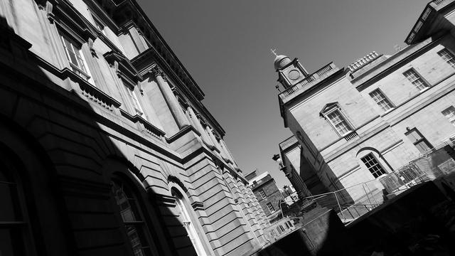
Bellevue: the thread about the finest and least wanted house in the New Town
I got a nice message today (September 12th) from WordPress (the foundations upon which the walls and roof of this website sits) to tell me that it had just passed 100,000 views. If I had known this particular milestone was approaching, I might have tried to be more organised and have a thread ready that was somehow relevant. But I didn’t, and so I don’t. Sorry. You’ll just have to settle for one on Bellevue House, which I happened to be looking at today.
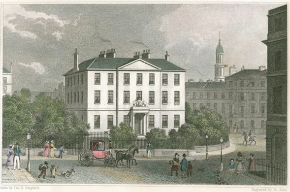
Bellevue House, by Thomas Hosmer Shepherd, coloured version of the engraving from “Modern Athens”, 1829
“Bellevue House? Where’s that?” I hear you ask. Well, it isn’t anywhere, not any more – it was demolished 180-odd years ago. But when it was somewhere, it sat in the centre of Drummond Place in the so-called Second New Town; a fine building, but one that sat awkwardly, offset and facing the “wrong” way to be a monumental centrepiece to the square.
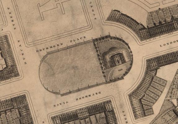
Drummond Place, shown on Kirkwood’s 1819 town plan, which cleverly included the building façades. Reproduced with the permission of the National Library of Scotland
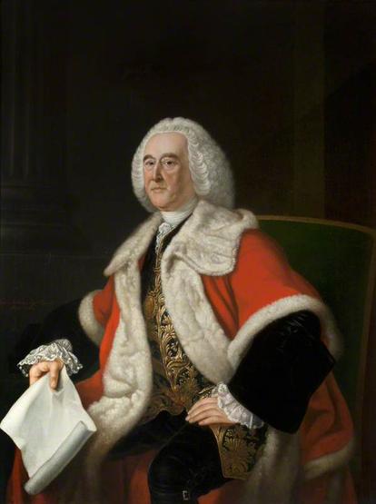
The square itself was named for George Drummond – the Lord Provost of Edinburgh – who held that post a record 6 times between 1725 and 1764, and one of the driving forces behind the First New Town of Edinburgh and other great civic improvements such as the North Bridge and Royal Exchange.
Lord Provost George Drummond. CC-by-NC National Galleries Scotland
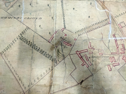
Drummond’s own house and estate – Drummond Lodge – occupied this part of the park and farmlands north of the City – bounded by Broughton village to the east, the Canonmills Haugh to the north and Gabriel’s Road to the east.
1759 survey of Edinburgh by Fergus and Robertson showing Drummond Lodge, just west of Broughton village © Self
Drummond died in 1766, his house and estate eventually being sold to Major General John Scott of Balcomie and Scotstarvit (in Fife), also known as Pawky Scott (“Sly Scott”) – a soldier, politician and gambler. The latter occupation was something he was rather good at and he allegedly won Dundas House (36 St. Andrew Square, now the Royal Bank of Scotland) off of Sir Lawrence Dundas in a wager. Dundas was unwilling to part with his brand new town house, so instead agreed to build a bigger and better one for Scott on the site of Drummond Lodge.
Royal Bank of Scotland, 26 St. Andrew Square, built as Dundas House for Sir Lawrence Dundas. CC-by-SA 3.0 Thunderwing
The new neoclassical mansion was built to designs by Robert Adam and had an extra bay on either side compared to Dundas House. The rear (north-facing) elevation had a projecting, rounded bay that contained a huge oval drawing room – a form unusual for Adam’s work.
Robert Adam’s final 1774 design for Bellevue House, front elevation. © Sir John Soane’s Museum, LondonScott named his new house Bellevue , after the palatial chateau of that name built by Louis XV for Madam Pompadour in 1750 – but he died in 1775 shortly before it was completed. The builder was George Brown, who also built George Square in the Southside. His widow and 3 daughters lived there, with the title passing to his eldest, Henrietta. She married William Henry Cavendish-Scott-Bentinck, 4th Duke of Portland – the Marquess of Tichfield – in 1795, who sold it and the grounds to the City for £11,375 4s 0d in 1800. There was a £1,050 annual feu duty. They had the option to buy the superiority within 7 years for a further £20,200.
Bellevue House looking northeast towards Leith in 1796, note that at this time the building is two storeys plus basement. Engraving by R. Scott after Alexander Carse, facsimile copy from the “Edinburgh Magazine; or Literary Miscellany”, vol 13-14.
The city didn’t really want the house, it wanted its vast parkland. “The whole place waved with wood and was diversified by undulations of the surface and adorned by seats and bowers and summer-houses, nothing in the town could be more delightful“. And it wanted to rip that up and develop it – by October that year they were soliciting plans to develop it into a new New Town. This was for the planned northern expansion of the New Town – the so-called 2nd New Town – and once again, this pre-existing boundary determines some of those street features that still exist today, 220 years later
Outline of Bellevue lands traced onto Google Earth aerial imagery. The houses stood in the gardens in the centre of what is now Drummond Place. The adjacent land holdings have been named
The elegant curve of Royal Crescent? It wasn’t intentionally like that, they just made good use of the working with the existing boundary between Bellevue and the Canonmills Haugh. The Haugh was owned by the trustees of Heriot’s Hospital, and they weren’t interested in the New Town scheme here. There was also a significant height difference between the two holdings here, so it was a natural boundary.
Royal Crescent, following the boundary between Bellevue and the Canonmills Haugh (which was the property of Heriot’s Hospital)
Bellevue Crescent? Well now you know where it gets its name from, you also know where it gets its shape from! The boundary here was between Bellevue and more land owned by Heriot’s Hospital. The old road to Canonmills that divided the two had a bit of a wiggle in it here, and it was expanded upon with the slender garden crescent with a monumental church at its centre.
Bellevue Crescent expands on the boundary between Bellevue and the land to the east owned by Heriot’s Hospital
Heriot’s also stood in the way of the development at “Old Broughton”, as did the other landowner, Mr Murray. And so here there’s an awkward and jarring series of roads and walls and lanes – the boundaries of the medieval village – that not even later attempts at regular, grid-aligned streets could make order out of.
The awkward boundaries within “old Broughton” also define where the Second New Town at first ended. The land in Broughton was owned by Heriot’s Hospital and a Mr. Murray
And even the grand showpiece crescent of Abercrombie Place works it’s way around a pre-existing boundary – the garden was not part of the development land at this time, and it’s not quite symetrical at its eastern end, the old boundary roadway of Gabriel’s Road (marked in white) messes things up a bit. The original street plan had Nelson Street come straight through from Dummond Place, emerging awkwardly about 2/3 of the way along Abercrombie Place, but it was soon centred into the crescent to give a more balanced prospect.
Kirkwood’s town plan, 1817, overlaid with Gabriel’s Road (white) and the Bellevue boundary (yellow). Reproduced with the permission of the National Library of Scotland
So you have to admit, William Sibbald and Robert Reid – who laid out this phase of the New Town – did a pretty impressive job of working around some wonky boundaries while keeping things ordered and regular and elegant. Their three crescents, to the north, the east and the south, were practical ways to use the land, but were the first such curved streets in Edinburgh and became very fashionable addresses. They also managed to centre the whole eastern section of the plan on Bellevue House within the new Drummond Place. The City didn’t have a use for the house itself and had been unable to lease it for residential use and so instead it was leased to the Board of Customs in 1802. The City wanted them out of the Royal Exchange (the City Chambers) to make more room for itself. The Caledonian Mercury called this arrangement “very honourable to the Government and beneficial to the City“, the “style of exterior grandeur” corresponded appropriately to the importance of the public establishment within. It would be 1805 before the Customs moved in, by which time the planned streets around it were only just beginning to emerge from the ground, so at this time the house continued to stand prominently in open land.
Bellevue House, sitting in its grounds, from Views in Edinburgh and its Vicinity by James & Henry Storer, 1820. Note the royal coat of arms on the portico above the front door.
Coincidentally, Lawrence Dundas – who had “lost” his house to Scott in that bet that would result in him paying to have Bellevue built – had died in 1781 and his house had been sold to the government who installed the Board of Excise there. The Boards of Customs and of Excise were separate institutions at this time, but Bellevue House occasionally gets labelled as the “Excise House“, when it was the “Custom House“; the former was on St. Andrew Square. The Customs couldn’t quite fit into the building initially, and so had an extra storey added by the Town Council before taking up occupation. They also required that the surrounding 1 acre of land be fenced of, which formed the nucleus of the later Drummond Place Garden. The Excise found at this time that many of the taxes they collected were being abolished and were downsizing as a result. They vacated Dundas House in 1825, (which was sold to the Royal Bank) and moved in with the Customs at Bellevue. But not even the joint establishments of the Customs and the Excise could keep the building filled – many of their functions finding themselves sent south to London, and the building soon began to empty. By the late 1830s, 17 of its rooms lay vacant.
The Town Council had hoped to buy Dundas House for itself, as a mansion for the Lord Provost but had been outbid by the Bank. They now found the government willing to sell their lease on Bellevue House back to them for £5,000, so they were keen not to lose out again. It was 1844 and the Lord Provost Adam Black had also heard rumblings that the Edinburgh, Leith & Granton Railway, planning to commence tunnelling its way under the New Town from Scotland Street to Canal Street station, might move to buy the house and the square of Drummond Place for itself and erect workshops or a station. He “considered it a matter dangerous to the city that this property should come into the hands of any railway company” who might cause “considerable danger of nuisance… in that part of the town, which it was of importance should be kept in as beautiful a state as possible“. Lord Provost Black had a particular concern in his matter; he resided in a house on Drummond Place!
Scotland Street Tunnel, northern portal. CC-by-SA 2.0, Jim Barton via GeographOn this subject, the Lord Provost was right – partially. The Railway did want to buy Bellevue House, but for no other reason than to demolish it. It was directly on top of the line of their tunnel and they did not wish the expense and difficulty of going around it, or trying to reinforce the foundations. And so in December 1845, the City struck a bargain with the Railway and the Board of Customs. The City bought the house for £5,000, with the Customs moving to smaller premises on Picardy Place. They in turn, after negotiations on the terms had completed, sold the house to the Railway for £3,200, who would then pay to demolish it. It was estimated that £1,200 of its materials would be of use in constructing its stations and buildings. Everybody won: the Railway saved much more in simplifying the construction of the tunnel than it had spent on the house. The City prevented the Railway building on the land, and the proprietors of Drummond Place got rid of an awkward building that spoiled the symmetry of their square and were able to buy the site and incorporate it into their private pleasure garden for the sum of £1,200.
The line of the Scotland Street tunnel, passing directly under the site of Bellevue House. Google Earth aerial imagery.
By February 1846, the Edinburgh Evening Post reported “in a few days it will be levelled with the ground” and that its removal would be “a great improvement to Drummond Place, besides opening up the vistas from Duke (Dublin) Street northward and London street eastward“. And just like that, one of the biggest, but least wanted, houses in the New Town was gone and Drummond Place got its private garden in the centre and they all lived happily after. (Until, that is, someone dared to paint their door pink. And then green. And then off-pink.)
Now and Then (1829) comparison in Drummond Place, showing Bellevue House as the Custom House, 1829 engraving by Thomas Hosmer Shepherd. © Edinburgh City Libraries
Note to readers: unfortunately in April 2026, a third-party plug-in more than exceeded its authority and broke many of the image links on this site. No images were lost but I will have to restore them page-by-page, which may take some time. In the meantime please bear with me while I go about rectifying this issue.
If you have found this site useful, informative or amusing then you can help contribute towards its running costs by supporting me on ko-fi. This includes my commitment to keeping it 100% advert and AI free for all time coming, and in helping to find further unusual stories to bring you by acquiring books and paying for research.
Or please do just share this post on social media or amongst friends and like-minded people, sites like this thrive on being shared.
Explore Threadinburgh by map:
Travelers' Map is loading...
If you see this after your page is loaded completely, leafletJS files are missing.
These threads © 2017-2026, Andy Arthur.
NO AI TRAINING: Any use of the contents of this website to “train” generative artificial intelligence (AI) technologies to generate text is expressly prohibited. The author reserves all rights to license uses of this work for generative AI training and development of machine learning language models.
#Lochend #Logan #Restalrig #StMargaret