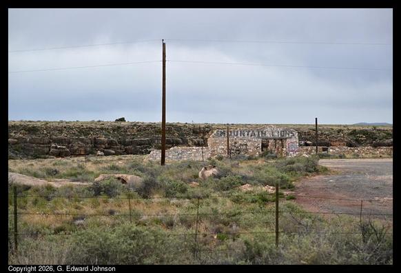
https://edwardiseverywhere.blogspot.com/2026/04/needles-california-on-route-66.html
#Route66 #California #RoadTrip #NeedlesCA
Sometimes circumstances require an out-and-back road trip, but if you can, take a circle route or loop trip. Here are a couple of ideas, on my personal blog:
https://www.sheilascarborough.com/2026/04/02/loop-trip-travel-post-friday/
Lisbon and northern Alentejo
We dipped south into the northern part of the Alentejo region, before a detour back into central Portugal conveyed us to the outskirts of Lisbon. Our route would then return us to northern Alentejo as we crossed Portugal into Spain. For this away mission we deliberately omitted Lisbon itself and also the Algarve; that (and southern Spain) will wait for another time.
Coordinates
Into Alentejo
A cactus garden in the evening light, seen from our van door on pitch at an eco-commune in Proença-a-Velha (📷1). The next morning, two new wildlife sightings: B’s first-ever look at Rhipicephalus sanguineus | the brown dog tick—we’ve been vaccinated against TBE (📷2) and a mongoose that crossed the road in front of us. Later, having continued south into the Alentejo region, we made a spontaneous visit to Anta | dolmen 1 of São Gens (📷3); it’s one of four megalithic tombs near Nisa that may have been erected as early as 3500 BCE. Castelo de Vide was a picturesque drive-by, developed around a 13th–14th C. hilltop castle (📷4); it’s also known for whitewashed houses, Jewish history and surrounding greenery.
Marvão is an attractive fortified town, dramatically located at ~860m on a ridge in the Serra de São Mamede, providing stunning views in all directions—including across the Alentejo plains into Spain. The village itself is pretty to wander, with its white walls/ red roofs (📷1) and immaculate gardens (📷2). Castelo de Marvão | Marvão Castle is well-worth the 1,50 € entry fee. It was begun by a 9th C. Islamic knight and taken by Christian forces around 1160–66 CE. The Moorish fortress underwent major redevelopment after the Christian reconquest of Iberia and it was strengthened during the 13th C. under King Dinis of Portugal. The massive 15th–16th C. vaulted cistern, intended to supply the castle during sieges, is quite a feat of late medieval engineering (📷3). The stone walls follow the natural contours of the mountain and the battlements are walkable; the keep is intact and can be climbed (📷4). We witnessed Gyps fulvus | griffin vultures, describing lazy circles on the thermals, and atop the keep were buzzed by fast-moving swifts. We found Marvão wasn’t overly commercialized and it was surprisingly quiet on a (pre-season) Saturday.
An impromptu study of the doorways and windows of Marvão. Who, across the centuries, has knocked and been invited into a dimly-lit interior, or looked out at the world and thought “There really is no place like home”?
Back into central Portugal
Convento de Cristo | Convent of Christ is a UNESCO World Heritage Site in Tomar, recognized for its blend of architecture (Romanesque, Gothic, Manueline, Renaissance, etc.) and historical links to the Knights Templar and to the Age of Discovery.
The Knights Templar and the Order of Christ
The Knights Templar, warrior monks/ a Catholic military order, were founded in 1119 CE following the First Crusade to protect pilgrims traveling to Jerusalem; they were disbanded by papal bull (public decree) in 1312 following false accusations of heresy by King Philip IV of France. In 1319 Portugal’s King Dinis I determined to reuse/ repurpose/ recycle their assets (knights, goods, technology and knowledge) as the Order of Christ. The former Templar castle was thus superseded by the Convent of Christ, with Tomar the spiritual and administrative seat of the new Order of Christ.
The Order of Christ helped finance and organize many of Portugal’s early voyages during the Age of Discovery. With the Order led by Prince Henry the Navigator, resources were directed towards maritime expeditions along the coast of Africa. The Order’s red cross emblem was painted on the sails of Portuguese caravels, a visible symbol of exploration in search of commercial opportunities, spreading Christianity and expanding Portugal’s influence.
🤔 Curiosity
The convent’s centrepiece is the church. Seen from the within the main body, the rotunda impresses (📷1); it began as a 12th C. early Templar Romanesque fortified oratory, inspired by the Temple in Jerusalem. Early in the 16th C. it became a chancel with an ambulatory (sequential iconographic panels telling a religious story). This view is from beside the central drum, looking towards the ceiling (📷2). The rotunda’s window frames are highly detailed (📷3). The exterior window on the church’s west façade (1519–13 CE) exemplifies the late Gothic “Manueline” style, with maritime/ exotic motifs reflecting wealth brought back from overseas (📷4).
Claustro do Cemitério | Cemetery Cloister, with a view of the church, is one of a number of cloisters within the complex (📷1); initially built in the 15th C. it was remodelled in the early 17th C. and is named for its role as a burial ground for friar knights. The end of one of three corridors making up the 40-cell Dormitório Grande | Main Dormitory (📷2); completed in 1543–45, the azulejo dado tiles were added in the 17th C. We also toured the Refeitório | Refectory c. 1535 and Cozinha | Kitchen, which wasn’t completed until after 1550. On the eastern flank of the convent, Castelo De Tomar | Tomar Castle—closed for restoration—was built c. 1160 as a stronghold and headquarters of the Portuguese Knights Templar (📷3); it was transferred to the Order of Christ and later integrated into Convento de Cristo. On the western flank of the convent is Aqueduto dos Pegões | Pegões Aqueduct—access here was also barred. However, there is an access tower ~3km away on Rua do Saibreiro from where two tiers of stone arches can be seen (📷4). Although it looks Roman-like, the 6km-long structure was built 1593–1614 CE to supply water to the convent.
Nazaré is globally recognised among the surfing community for it’s big waves, which can reach 20–30m in height. Just offshore here is one end of the largest submarine trench in Europe, at ~230km long and ~5km deep. The Nazaré Canyon funnels Atlantic swells towards the shore, where the abrupt change in depth compresses wave energy, refracting and amplifying it. Our visit to Nazaré coincided with a coastal wind warning (gusts up to 55 km/h) so we saw no surfing, but we did see surf! Praia da Nazaré is the city’s main golden-sand beach, viewed here from the rocky headland at the north end of the beach (📷1). On the tip of the headland is Farol de Nazaré, a lighthouse atop a fort, providing a vantage point from which to watch the breakers roll in to adjacent Praia do Norte (📷2). We watched long waves crest and collapse, all the while the wind whipping off the tops in sheets of spray (📷3). Other waves broke apart thunderously on the rocks directly below the lighthouse (📷4).
After departing Nazaré we entered the walled medieval city of Óbidos via Porta da Vila, the main gate built c. 1376 CE, which integrates a small baroque chapel lined with azulejo | tiles depicting biblical scenes, installed c. 1740–45 (📷1). Rua da Direita is the main cobbled street leading from the gate to the castle, lined with shops, cafés and traditional (guest) houses (📷2). Muralhas de Óbidos | the town walls are well-preserved and make for an alternative route from Porta da Vila to the castle (📷3), although some fellow visitors seemed unnerved by the absence of railings. Castelo de Óbidos | Óbidos Castle was originally Moorish; it was expanded following the Christian reconquest. The Governor’s Palace was rebuilt in the 16th C. and has been a hotel/ restaurant since 1948. Adjacent is Igreja-Livraria de Santiago, a former church converted into a bookshop—in keeping with the town’s status as a UNESCO Creative City of Literature (📷4).
The ramparts of Óbidos provide views out into the surrounding landscape, but also draw the eye inward across town house courtyards, where varied use is made of small outdoor spaces (📷1–3). Touristy it may be, but “the thing” in Óbidos is ginjinha | cherry liqueur, served in small cups made of chocolate. The correct means of consumption, we are reliably informed, is to drink first then eat the cup. We can neither confirm nor deny whether we presently have cherry liqueur aboard this vanship…
Lisbon region
Parque Natural de Sintra-Cascais lies to the west of Lisbon and covers a stretch of Atlantic shoreline as well as extending into the Sintra hills. Our first stop was Azenhas do Mar, where whitewashed houses are stacked on steep cliffs of limestone and shale above a beach and seawater pool (📷1). On to Cabo da Roca | Cape Roca, the westernmost point in Continental Europe. The landmark was crowded and while the view to the open Atlantic was thought provoking, the sea cliffs to the north were more dramatic (📷2). There are marked trails on the headland beginning near the parking area; this view looks south back to the cape’s lighthouse (📷3), while this view is towards the golden sand beach of Praia da Ursa lying at the bottom the cliff (📷4).
In Parque Natural de Sintra-Cascais we chose the PR4 CSC – Guincho Coastal Route as our morning hike, parking in Malveira da Serra. Once we cleared the village the trail took us into open scrub-covered hills, with a view down to the coast at Praia do Guincho (📷1). After intersecting the coast the trail runs along the cliffs tops and looks down into several rocky coves (📷2). At Praia do Abano we reached the ruin of Forte do Guincho c. 1642 CE (📷3); the view here is northeast in the direction of Cabo da Roca. Praia do Guincho is a wild Atlantic beach backed by dunes (📷4). The uphill leg back to the village involved a fair bit of road walking and was comparatively dull: a 10km/ 3h return loop.
Coastal flowers noted in Parque Natural de Sintra-Cascais include Armeria welwitschii | the divine thrift, endemic to coastal central Portugal (📷1); Thapsia villosa | the villous deadly carrot, a poisonous native (📷2); Cistus ladanifer | the gum rock-rose, native to the western Mediterranean and predominant on this trail—here providing a home for Synema globosum | the Napoleon spider (📷3); and the native Centaurium erythraea | common centaury (📷4).
Also noted: Convolvulus althaeoides | mallow bindweed; Erophaca baetica | Iberian milkvetch; Centaurea pullata | Iberian knapweed; Anacamptis pyramidalis | pyramidal orchid; Orobanche crenata | bean broomrape; Anthyllis vulneraria | common kidney-vetch; and Papaver somniferum | opium poppy.
The Sintra hills within the Parque Natural de Sintra-Cascais are the setting for a number of sites included in the UNESCO Cultural Landscape of Sintra. A retreat for Portuguese royalty and aristocracy since the medieval period, Sintra became a Romantic playground blending natural scenery and monumental architecture, starting in the 19th C. under King Ferdinand II. Palácio da Pena | Pena Palace was commissioned by the said king, completed in 1854 with vivid colours and eclectic styles (📷1). Castelo dos Mouros | the Castle of the Moors was begun in the 9th C. to protect Sintra a thousand years before Pena Palace was even conceived (📷2); the 19th C. partial restoration is seen here from the palace. We passed beside Palácio Nacional de Sintra | the National Palace of Sintra (📷3), recognizable by its two massive white conical chimneys, when descending to the historic town centre (📷4). There are multiple other sites and interiors we missed in a ~10km/ 3.5h loop walk costing 24 € (Pena Park only x2).
Sintra: brace, brace, brace!
Visiting Sintra was a financial*, logistical (parking, limited suitable pitches in the vicinity, choice/ spread of sites) and physiological (crowds, car crime and pickpocket risk) challenge.
*For example, four top-tier points-of-interest = [Park & Palace of Pena 20 € + Moorish Castle 12 € + National Palace 13 € + Quinta da Regaleira 25 €]x2 + [No. 434/ 435 bus pass 10,96 €]x2 + 1,80 € paid motorhome parking would have cost us 164 € for the day.
✳️ Tips and tricks
After inching our way through Lisbon’s rush-hour traffic we made camp south of the city. This experience, combined with the stress of navigating Sintra, only served to reaffirm our decision to skip revisiting Lisbon’s attractions. We thus arrived at Praia De Santo Antóniois, one of the beaches along Costa da Caparica, with a promenade, fisherpeople and surf school. Later we attempted to visit Praia da Figueirinha near Setúbal on a recommendation, but found the access road closed. We thus bid farewell to the Atlantic and turned inland to begin our return journey.
FisherpeopleSurf schoolA little more northern Alentejo
One doesn’t visit Évora’s historic centre to see extensive well-preserved Roman ruins; rather, the city’s UNESCO listing reflects continuous occupation since the Roman era, when it was known as Liberalitas Julia. Distinct Roman remains are few, although there is more legacy embedded in the fabric of the medieval town. Templo Romano de Évora | the Roman Temple is the primary monument of Roman Évora, built in the early 1st C. CE with granite columns featuring Corinthian capitals (📷1); it’s one of the best-preserved Roman temples in Iberia and was likely dedicated to the cult of the Emperor. Porta de Dona Isabel is a remnant access point to the Roman city (📷2); surviving sections of wall have been incorporated into later fortifications, but it still defines the original Roman urban perimeter. Termas Romanas | the Roman baths c. early 1st C. CE are excavated beneath Câmara Municipal De Évora | the city hall (📷3); this rounded structure is the laconicum, a central space used for sweating in hot, dry air. Not Roman, but nevertheless a curiosity, Igreja de S. Francisco | St Francis’ Church contains the early 17th C. Capela dos Ossos | Chapel of Bones, with three naves formed from arrangements of human bones sourced from local burial grounds (📷4) in a move predating modern concepts of informed consent and planning permission!
One of Europe’s densest megalithic landscapes lies on the outskirts of Évora. We selected a few of the primary sites, beginning with Menhir dos Almendres, a 4m tall isolated standing stone near the village of Nossa Senhora de Guadalupe (📷1). Further along the same dirt road—we had to abandon the van and walk—is Cromeleque dos Almendres, a stone circle constructed ~7,500 years ago, comprising 100+ menhirs, making it the largest monument of its kind in Iberia (📷2). From the adjacent village to the south we walked to Anta Grande do Zambujeiro, one of the largest dolmen (burial monuments) in the world, exemplifying Neolithic funerary architecture (📷3); it’s ~5,500 years old—built at the same time as the pyramids in Egypt and Stonehenge in England. During our time travels in the local landscape we had several meetings with the endemic Berberomeloe castuo | Portuguese red-striped oil beetle (📷4); the body resembling a black menhir, its defense mechanism is to excrete an oily haemolymph containing the toxin cantharidin, which causes severe blistering to human skin.
Interpretation aids and access advice
Call in first at Centro Interpretativo dos Almendres for information (there is a series of interpretation panels) and access advice regarding directions, road condition and walking requirements.
✳️ Tips and tricks
The compact village of Monsaraz features whitewashed buildings and cobbled lanes in a layout little changed since medieval times (📷1). Castelo de Monsaraz, a 13th C. hilltop fortress, now contains a bullring built by villagers in 1830 using stones harvested from the semi-ruined parade ground and walls (📷2). Albufeira do Alqueva | Alqueva Reservoir, one of Europe’s largest artificial lakes, is seen from various vantage points, with views over the Alentejo plains and into Spain (📷3). From the walls we also looked over large-scale olive groves, “montado” (a traditional agroforestry system combining cork or holm oaks with grazing land) and vineyards (📷4).
Forte de Santa Luzia at Elvas is part of the UNESCO listing for “Garrison Border Town of Elvas and its Fortifications”. The site is one of the best-preserved examples of early modern military architecture in Europe, demonstrating the 17th C. bastioned fortifications developed as a response to artillery. For its part, this fort—one of two near the fortified city—played a border defense role, layed out on a hill in a polygonal star plan with bastions, dry moat and thick ramparts. Such geometry eliminated blind spots and enabled crossfire; a guarita | sentry box would be located at intervals, often on prominent wall angles to shelter sentinel soldiers (📷1). During the Portuguese Restoration War (1640–68) in which Portugal fought to restore independence from Spain, soldiers stationed here (📷2) saw repeated action, especially in the 1659 campaign—a Spanish offensive culminating in the Battle of the Lines of Elvas. The thick ramparts, engineered to absorb and deflect artillery fire, include cannon positions to return fire (📷3); this is a 7.5cm calibre English campaign piece with wooden gun carriage. Within Casa do Governador | the governor’s house is an unusual vertical “staircase” affording access to an observation terrace (📷4).
After our fort visit we crossed the border back into Spain. Até à próxima, Portugal!
#2026 #camperVan #europe #hiking #nature #nomad #portugal #roadTrip #romans #travel #unesco #vanLifeCentral Portugal
Having completed our tour of northern Portugal, we drove into the central region, first along the coast and then inland to a mountainous area peppered with historic hilltop towns.
Coordinates
Ovar and the coast
Ovar is a town in central Portugal known for its residential concentration of “azulejos”, ceramic tiles developed in the Iberian Peninsula under Moorish influence. By the 16th C. Portuguese artisans had developed distinctive styles for use in walls, floors and façades; sometimes they were repeating geometric designs, sometimes they were unique creations depicting historical, religious or daily life scenes. Typically used indoors in palaces or public buildings/ churches, what makes Ovar special is their widespread integration into exteriors of “ordinary” houses. Many examples are from the 19th or 20th C. and can be viewed simply by wandering aimlessly about the town centre.
More of Ovar’s azulejos, within the context of house façades. Also noteworthy during a tile-spotting wander about the historic centre, there are seven chapels representing Christ’s Scenes of Passion, regarded as the “most representative artistic motif of Ovar.”
Before leaving Ovar we obtained a “Pão de Ló” sponge cake, the local specialty, for later sampling; the lady who sold it proudly told us it was her 2x great grandfather’s recipe:
Pão de LóThe reserva natural das Dunas de São Jacinto | São Jacinto Dunes Nature Reserve is bounded on one side by the Atlantic Ocean and on the other by the tidal mouth of ria de Aveiro. It protects an area of dunes but mostly comprises pine forest, offering a habitat for mosquitoes, brambles and gorse. From the hide at Pateira Pequena (a small pond) we heard frogs, but didn’t linger under threat of exsanguination. What did impress was the sheer volume of Trichilogaster acaciaelongifoliae | the longleaf wattle gall wasp, which parasitises the invasive Acacia longifolia | longleaf wattle native to southeastern Australia (📷1). We also met Chalcophora mariana | the pine-borer beetle, native across much of Europe (📷2). The dunes of Praia de São Jacinto can be overlooked from a platform at the end of a boardwalk (📷3). From the hide at Pateira Grande (a large pond) we saw only a solitary duck.
Our next stop was to be Aveiro, billed as the “Venice of Portugal”; the canals didn’t impress sufficiently as we drove by hunting for parking, so we kept going, but later heard from fellow travellers it was really nice. Being Easter, Núcleo Museológico do Sal on the coast wouldn’t be open for our visit, so we turned inland. You win some, loose some!
Conímbriga and Coimbra
Conímbriga, south of Coimbra, is the largest and best-preserved Roman archaeological site in Portugal; its mosaics are considered among the best surviving in Europe. Originally a Celtic settlement (“-briga” implies fortification and pre-Roman foundations are visible), it flourished from the 2nd C. BCE due to its strategic position on a key road linking Olisipo (Lisbon) and Bracara Augusta (Braga). It became a prosperous city of some 10,000 people at its peak in the Roman province of Lusitania, before being gradually abandoned during 5th C. CE Germanic (Swabian) invasions. Although ~80% of the site remains underground, excavations reveal the typical features of a Roman town. The ruins comprise houses of the elite, a forum (civic centre), thermae (baths), defensive walls, road infrastructure and an amphitheater remnant. The open-air site offers in-situ insights into provincial Roman urban planning, social stratification (elite villas vs. common housing) and engineering (water systems, heating, fortifications), while the on-site museum exhibits items from daily life, coins, tools, mosaics and sculptures recovered from the (ongoing) excavations.
Highlights include the 3rd C. mosaic in the “House of the Skeletons” (📷1); 2nd C. private baths in the “House of Cantaber” (📷2); and the water garden with mosaics in the 1st C. “House of Fountains” (📷3)—note the minotaur in a maze on the right. Also in the same house is a hunting scene mosaic (📷4).
The Universidade de Coimbra | University of Coimbra (UdeC) complex occupies a hilltop overlooking the Rio Mondego (📷1); it’s one of Europe’s oldest universities, founded in 1290 CE. Together with the Alta (upper town) and Sofia (lower town) areas of the city historically associated with the university, it’s a UNESCO World Heritage Site. Paço das Escolas | Palace of Schools, a former 12th C. royal palace and tower, seen from the main university courtyard (📷2). Also adjoining the courtyard is Biblioteca Joanina | the Joanina Library c. 1728 (📷3), which incorporates a lower floor prison (self-regulation separated academics from common criminals until 1834) and middle floor exhibition area. The jewel is the library’s Baroque “Noble” upper floor, featuring gold-leaf/ oak interiors and centuries-old books. Regarded as one of the world’s most beautiful libraries, it actively supports bat colonies for moth control—with certain bat poo precautions. All photography is prohibited during the 10min tour slot in here, so this interior image is from UdeC (📷4).
Within the UdeC’s former palace complex is the Chapel of São Miguel | St. Michael’s Chapel, featuring azulejos (tiles) and a grand organ (📷1), and Sala dos Capelos | the Great Hall of Acts, formerly the throne room, with carpeted walls and painted ceiling (📷2). In the nearby Museu da Ciência | Science Museum, this uncomfortable-looking lecture theatre predates the adjacent Physics Cabinet, an 18th C. collection of teaching instruments, by some 100 years (📷3). The Cabinet of Curiosities is a captivating display room for bizarre objects (📷4). We also visited the Chemistry Lab before descending through the medieval streets of the Alta to view the 12th C. Sé Velha de Coimbra, a Romanesque fortress-like cathedral. Then along the Rua da Sofia in the Sofia area, lined with former colleges and convents that seemed somewhat neglected externally.
Piódão
Aldeias Históricas de Portugal is a heritage and tourism network for promoting/ preserving 12 historic villages in central Portugal. Piódão is on the list: a medieval village built onto steep terraces in the Serra do Açor mountains at ~700m elevation (📷1). Villagers utilised terraces to support agriculture, herding and bee keeping; their produce was exported by caravan/ ox cart via the royal road at the top of the mountain, which would also bring in salt and fish from the coast. The white lgreja Matriz do Piódão, an 18th C. parish church, contrasts against the darker schist stone of the villager’s houses (📷2). With abodes stacked almost one atop the other, residents are sometimes challenged to maintain a front garden (📷3). They do have a thing for blue doors (📷4); there’s no official reason, but theories include that the colour was initially adopted due to isolation and a limited (blue) paint supply, creating a tradition that has become an iconic look.
We took a trail linking Piódão to the village in the valley below it, Foz D’Égua. With the river to our right the path wound its way downstream through abandoned terraces and dilapidated stone huts (📷1). We noted coral-like Schizophyllum commune | the split-gill mushroom, a native fungus (📷2). The overcast sky, stillness and charred landscape created a sense of desolation: 64,000ha burned as a result of a lightning strike during a dry storm here in Aug 2025—the largest wildfire in Portugal’s recorded history (📷3), but green growth has begun reclaiming the slopes. Foz d’Égua is a schist hamlet known for its natural “river beach” (Praia Fluvial) and twin stone bridges at the confluence of two mountain streams (📷4). This was a 6km/ 2.5h loop.
Serra da Estrela
Rota dos Seis Lagos | Route of the Six Lakes is a 9km/ 3.5h loop trail within Parque Natural da Serra da Estrela | Serra da Estrela Natural Park. The park encompasses the Serra da Estrela mountain range and is the largest protected area in mainland Portugal. We parked near the dam at Lagoa Comprida (📷1); on the ridge above the reservoir is Torre, at 1,993m the mainland’s highest peak. Many examples of “erratic boulders” line the path (📷2); these have been transported and deposited by glacial ice. Covão dos Conchos isn’t a natural sinkhole or a portal to another dimension—it’s a clever piece of engineering built in 1955 (📷3). This funnel-shaped spillway in Albufeira dos Conchos is part of a hydroelectric system that diverts water into Lagoa Comprida. This prickly-looking fellow is the caterpillar of Macrothylacia rubi | the fox moth (📷4).
The onward trail from Covão dos Conchos wasn’t always easy to see, especially where covered in shoulder-high broom. The regular cairns certainly help way finding, but a GPS/ topographic map with GPX track to follow is recommended. Some of the trailside yellow flowers were Narcissus bulbocodium (previously noted); others were Narcissus rupicola, a species of tiny daffodil (1–2cm diameter) endemic to the Iberian Peninsula, found in rocky habitats/ mountainous areas (📷1). The remaining lakes came thick and fast, beginning with Albufeira do Lagoacho (in the distance) and Lagoa Redonda. Following recent rain the trail was waterlogged in places (📷2). Lagoa Seca was at an advanced stage of infilling (📷3). Next up was Albufeira do Covão do Forno before reaching the last lake, Albufeira do Covão do Curral (📷4). We completed the loop by walking atop covered canals—having seen all seven of the six lakes!
You can experience some impressive scenery within Parque Natural da Serra da Estrela | Serra da Estrela Natural Park without going hiking. Here’s a look back during the drive up the mountain from Loriga towards Lagoa Comprida (📷1). En route to Manteigas from the lake, this view from the mountain pass is from near the high point/ turnoff to Torre (📷2). The road ahead during the descent towards Manteigas from Miradouro do Covão (📷3). At a lower altitude, Covão D’Ametade is a popular picnic area hollowed out by a glacier (📷4); deer once grazed here.
For our second hike in Parque Natural da Serra da Estrela we tried twice to reach the trailhead for Volta das Penhas Douradas, but access was barred to non-residents. Instead we took PR13 MTG – Rota das Faias, a 5km/ 1.5h loop on forestry roads. Callophrys rubi | the green hairstreak butterfly was present in numbers on the trail (📷1). Points of interest along the route include the Chapel of São Lourenço with views over the Zêzere river valley, a fire watchtower (📷2) and a milk hut once used by shepherds to protect sheep’s milk from the sun. The main draw is perhaps the remnant forest, comprising 400 year old oaks, Pseudotsuga menziesii | Oregon pine (a.k.a. Douglas fir) and a small stand of Fagus sylvatica | European beech (📷3) planted in the early 20th C. The trail offers views into Vale Glaciário do Zêzere | the Zêzere glacial valley, upstream from Manteigas, formed 30,000 years ago and a star feature in the Estrela UNESCO Global Geopark (📷4).
Belmonte and Idanha-a-Velha
Belmonte and Idanha-a-Velha are both part of the Aldeias Históricas de Portugal | Historical Villages of Portugal network. “Belmonte” references the town’s view of the eastern slopes of the Serra da Estrela mountains (📷1). It’s the birthplace of Pedro Álvares Cabral, who claimed Brazil for Portugal in 1500 CE and whose family repurposed the town’s 13th C. castle into a residence (📷2). A Jewish community rode out the Inquisition here; this heritage is evident in the Jewish quarter and synagogue. Idanha-a-Velha is a very small, less touristy village near Monsanto. With Roman ruins, a Visigothic cathedral, medieval fortifications and a 20th C. manor-style house, Casa Marrocos (📷3), it certainly has history. It also has resident storks (and cats), stepping stones for crossing the river, and views out to the surrounding olive groves and granite hills. Here, you could readily find a quiet place for a nap (📷4).
Monsanto
Monsanto is likewise part of the Aldeias Históricas de Portugal | Historical Villages of Portugal network. Voted the “Most Portuguese Village” in 1938, this fascinating town is built into the side of a 758m high hill strewn with huge granite boulders (itself noteworthy in UNESCO Geopark Naturtejo) as seen here from the citadel in the castle ruins (📷1). A 12th C. castle built by the Knights Templar replaced a Moorish fortification (ceded in 1165 CE); it was expanded significantly in the late 13th/ early 14th centuries with major alterations in the early 19th C. and restoration in the 1940–50s, forming the profile seen today. With limited space between the giant barrocos | boulders, the villagers simply integrated them into lanes (📷2) and into dwelling walls/ rooftops as architectural features—although this interior (the Gruta | Grotto) is actually a former pigpen (📷3). Previously distributed, furdas | pigpens were later clustered on the town peripheries for public heath reasons; they traditionally feature a drystone domed shelter and circular enclosure (📷4).
From Monsanto we continued south into Portugal’s Alentejo region.
#2026 #camperVan #europe #hiking #nature #nomad #portugal #roadTrip #romans #travel #unesco #vanLifeKorsika 25/26 Teil 10: Strandspaziergang, Wasserfall und Bergstraßen

#Gallup, NM offers a range of #lodging options, from budget-friendly hotels to historic and upscale choices. Visitors can find major brands like Best Western, Hilton Garden Inn, and La Quinta, as well as historic and unique stays like the El Rancho Hotel.
#VisitGallup #travel #Route66 #roadtrip #weekendgetaway #NewMexico
[3/3] Mérida cont. Museo Nacional de Arte Romano | National Museum of Roman Art houses artefacts from Augusta Emérita, such as this original 1st C. CE statue of Ceres, goddess of agriculture, from the scaenae frons | backdrop of the Theatre (📷1); the building itself is inspired by Roman brick arches. Casa del Mitreo is another elite residence, built in the late 1st C. outside of the city walls & featuring mosaics, but also notably retaining multiple residual frescoes, such as these two candelabra | candlestick holders (📷2); it was initially mistakenly identified as a temple dedicated to Mithras. The remnant core of Arco de Trajano | Trajan’s Arch stands 14m high (📷3); it was originally clad in marble panels. The smaller Visigothic collection of the National Museum of Roman Art is housed in a separate building, closer to the Alcazaba; among the works is this 7th C. pilaste, a decorative element in this case featuring the motif of Roman window bars (📷4). The Visigoths took control of Mérida in the early 6th C. & it remained an important political & religious centre in the Visigothic kingdom. Our 13km wander through history in 30° took 5.5h.
🇪🇸 #spain #extremadura 🇪🇺 #europe 🚀 #travel 🚐 #camperVan #nomad #roadTrip #vanLife 🌍 #unesco 🏛️ #roman