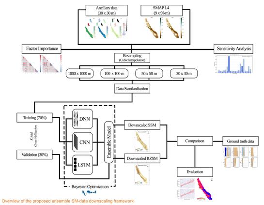
Ensemble Deep Learning Towards High-Resolution Soil-Moisture Mapping For Enhanced Water Management In California's Central Valley
--
https://doi.org/10.1016/j.envsoft.2025.106824 <-- shared paper
--
#agriculture #crops #groundwater #pumping #monitoring #agronomic #irrigation #planning #scheduling #wateruse #sustainability #wateruse #watersecurity #deeplearning #framework #soilmoisture #downscaling #watermanagement #california #centralvalley #ensemblemodeling #model #modeling #SMAP #satellite #rootzone #remotesensing #spatialanalysis #spatiotemporal #AI #sensitivityanalysis #fieldobservation #instrumentation #fieldchecking #seasonal #crop #crops #production #foodsecurity #NVDI #NDWI #ET #evapotranspiration #MODIS #pluvial
--
https://doi.org/10.1016/j.envsoft.2025.106824 <-- shared paper
--
#agriculture #crops #groundwater #pumping #monitoring #agronomic #irrigation #planning #scheduling #wateruse #sustainability #wateruse #watersecurity #deeplearning #framework #soilmoisture #downscaling #watermanagement #california #centralvalley #ensemblemodeling #model #modeling #SMAP #satellite #rootzone #remotesensing #spatialanalysis #spatiotemporal #AI #sensitivityanalysis #fieldobservation #instrumentation #fieldchecking #seasonal #crop #crops #production #foodsecurity #NVDI #NDWI #ET #evapotranspiration #MODIS #pluvial