you could use an oblique Mercator projection, but that only makes one side of the northern hemisphere larger
https://en.wikipedia.org/wiki/File:Mercator_Polar_Transverse.gif
#mapprojection #geodesy

@x_tof @lokjo

File:Mercator Polar Transverse.gif - Wikipedia

When you produce or display maps that show all of Canada, what map projection do you most often use?

There is no right or wrong answer, I am simply curious to know about your preferred map projection.

#maps #mapping #mapprojection #Canada #geospatial #GIS #geomatics #geography

Mercator conformal cylindrical
16.7%
Albers equal-area conic
0%
Lambert conformal conic
50%
I don't know or other projection
33.3%
Poll ended at .

Would this make GeoGuessr easier or harder?

https://xkcd.com/2807/

Would you prefer to live in this map rather than the default one? Personally, I like how me and my bestie from Madagascar would become neighbors.

#xkcd #comic #mapProjection #geography

Bad Map Projection: ABS(Longitude)

xkcd
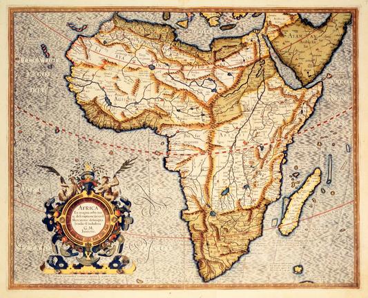
#AfricanUnion Joins Calls To End Use Of #Mercator Map That Shrinks Continent’s Size
--
https://www.theguardian.com/world/2025/aug/15/african-union-true-size-world-map-replace-mercator-version <-- shared media article
--
[just a reminder that the Mercator projection was developed in 1569 for use in marine navigation, so as to utilise “rhumb line[s],… a path on the Earth's surface that crosses all meridians of longitude at the same constant angle, allowing for a steady compass bearing to be followed.” (this is most specifically NOT pedantry!)
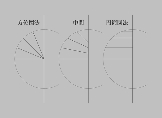
Glad that the suggested projection to make – rightly – the size of Africa be accurately represented is Equal Earth (https://equal-earth.com/, 4th figure) - rather than the (1) gross shapes distortion and (2) (erroneous) ‘socially concerned groups’ baggage that has been attached to the Gall-Peters projection]
#GIS #spatial #mapping #Africa #size #truesize #accurate #representation #stereotypes #CorrectTheMap #marine #navigation #campaign #equalearth #projection #shape #mapprojection #education #continent
#AfricaNoFilter #SpeakUpAfrica
Africa: What to Know About Mercator World Map That 'Shrinks' Africa's Size: [New Times] Africa's landmass is so big that Russia, China, India and the United States could fit in it. But that's not the impression you get when you look at the world map that's been in use for more than 450 years. http://newsfeed.facilit8.network/TMXq1H #Africa #MercatorMap #WorldMap #Geography #MapProjection

I don’t like the typical configuration of the interrupted Goode projection because it heavily skews Japan and neighbouring regions by positioning the central meridian for the Eurasian section closer to Europe. This may be convenient for those living around the Atlantic Ocean but it must be acknowledged that this design is not “neutral”.

#MapProjection #地図投影法

方位図法と円筒図法の間を取る件、この図のような捉え方ができるなあ。…という風にさっき思い至ったので、書き留めておきます。

#地図投影法 #MapProjection

前述の投影法の静止画版(東経 155 度を中央経線とする)。

#地図投影法 #MapProjection

極が点となる投影法を使った方がいいな。これは正角方位図法で投影し、縦方向に 66.7% に縮小してから逆変換し、ハンメル図法で投影し、その結果を縦方向に 150% に拡大した結果。

北極と南極が同時に見えてるのが特徴。フチ付近(中心から見て裏側)の歪み具合については、もっと賢く設計すればマシになるかも知れない。(私は投影法に関してはあまり賢くない。)

#地図投影法 #MapProjection

正距方位図法と正距円筒図法で同様の変換をした例。メルカトル図法と違って無限の彼方に吹っ飛ぶ事はない。投影の中心から見て裏側に、像がない部分が発生する。

#地図投影法 #MapProjection