Collegamenti #7
Maggio mi sta mettendo a dura prova, il maledetto, ma ho accumulato un’altra bella manciata di collegamenti e vorrei dargli un’ordinata (per modo di dire, visto che li piazzo disordinatamente in un post generalista), dunque eccomi qua.
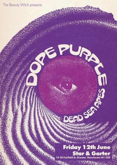
Questa volta inizio con il poster di un concerto: è quello dei Dope Purple, band noise e space rock taiwanese (che non conosco), e dei Dead Sea Apes, band drone rock e psichedelica di Albione (che invece conosco e amo), il 12 giugno a Manchester. Il poster è arrivato a me tramite l’account Mastodon di questi ultimi e lo ha disegnato Brett Savage, il loro chitarrista. Io fossi in voi darei un ascolto alla band (posso consigliare Night Lands e Rewilding) e una sfogliata al loro blog, dove trovate altri bei poster e tanta bella musica e tutto il cucuzzaro di informazioni; vi consiglierei di seguirli insomma, se non sono troppo indiscreto. Se poi vi trovate a Manchester il 12 giugno, be’, tanto meglio per voi.
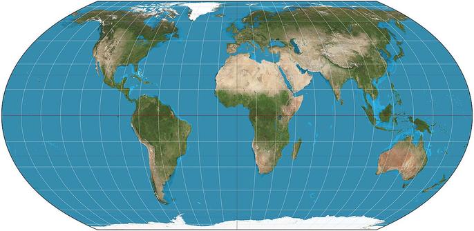
Una cosa molto bella che ho trovato ultimamente sul web è questo sito, Equal Earth, che fornisce versioni ad alta risoluzione e in diverse lingue di una mappa del mondo «che mostra i paesi e i continenti nelle loro dimensioni reali rispetto gli uni agli altri». È possibile centrare la mappa dove si vuole e scaricarla liberamente in diversi formati, persino in Illustrator. Non è fantastico? Questa cosa l’ho trovata sempre su Mastodon grazie al thread-richiesta partito da @bbacc e risolto da @zeppe.
Salto a cose meno amene – dissenso, repressione e autoritarismo dilagante – segnalando tre articoli paralleli, ma che dico paralleli, direi contigui: Italo Di Sabato che sciorina un po’ di dati sulla repressione delle manifestazioni in Italia, Amnesty International che ci parla della ripresa della mobilitazione sociale in Italia, e il buon Luigi Manconi che sottolinea l’assurdità e l’autoritarismo del reprimere una commemorazione funebre (è il caso degli anarchici che volevano dare l’ultimo saluto ai compagni morti in un’esplosione al parco degli Acquedotti).
E dal paesaggio sociale salto al paesaggio agricolo e naturale.
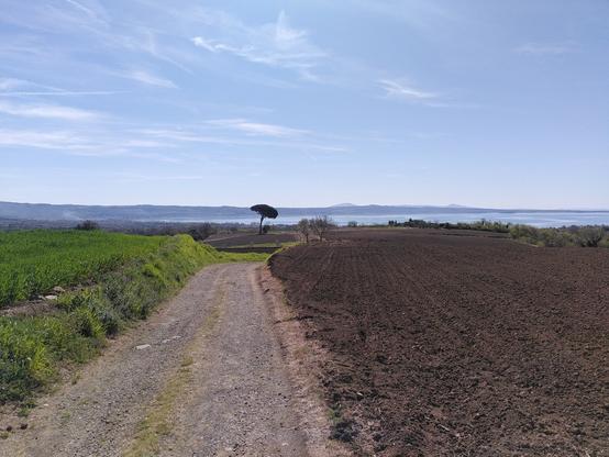
In questo ultimo mese e mezzo o giù di lì, a parte correggere, revisionare e impaginare come se ci fosse un domani, ho pure trovato il tempo per qualche pedalata lontano dal PC, che mi ha dato l’opportunità di decomprimere e di scattare qualche bella foto; oddio bella, carina dai. Di tutte quelle che ho fatto (non molte in verità), ne ho scelta una che ritrae un campo appena arato che digrada verso il lago (di Bolsena) e un maestoso pino-stella polare cui sono molto affezionato (qui c’è lo stesso pino preso da sotto). Lo scatto è di inizio aprile, vorrei trovare il tempo di tornare sul posto per ritrarre quel campo ormai pieno di piante di patate; mi prometto di farlo, ché sono sempre stato un devoto del famoso comandamento di Saramago (se mi sentisse parlare così…):
Bisogna vedere quel che non si è visto, vedere di nuovo quel che si è già visto, vedere in primavera quel che si è visto in estate, vedere di giorno quel che si è visto di notte, con il sole dove la prima volta pioveva, vedere le messi verdi, il frutto maturo, la pietra che ha cambiato posto, l’ombra che non c’era. Bisogna ritornare sui passi già dati, per ripeterli, e per tracciarvi a fianco nuovi cammini. Bisogna ricominciare il viaggio. Sempre.
– da «Viaggio in Portogallo» (1981), traduzione in italiano di Rita Desti
E il viaggio non è solo quello che ti porta dall’altra parte del mondo.
Per la serie social media, resistenza agli algoritmi e alle Big Tech, segnalo invece un interessante articolo della biblioteca dell’Università di Groninga che, avendo già abbandonato X per passare al fediverso (su un’istanza creata appositamente per la comunità della ricerca e dell’educazione olandese), ha ora aperto un dibattito su cosa fare di Instagram, scrivendo tra le altre cose: «L’alfabetizzazione informativa è al centro della nostra attività come biblioteca. Aiutiamo gli studenti a sviluppare un approccio attivo e critico alla ricerca delle informazioni: effettuare ricerche mirate, valutare l’affidabilità delle fonti ed elaborare le informazioni in modo efficace. L’algoritmo di Instagram fa esattamente il contrario: filtra ciò che gli utenti vedono in base al coinvolgimento, non all’affidabilità». Mi piacerebbe leggere una cosa del genere a queste latitudini, sto chiedendo troppo?
Torno brevemente alla musica, poi passo e chiudo.
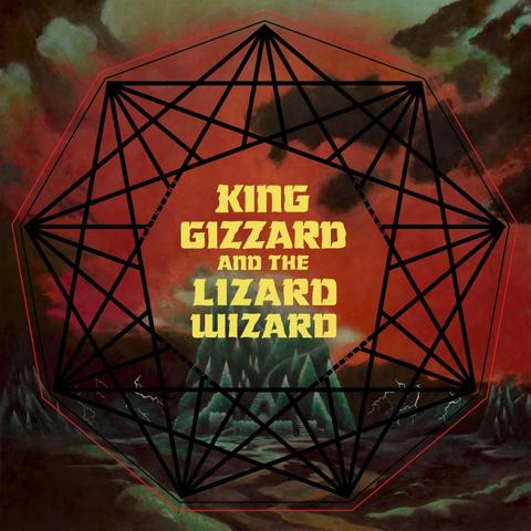
Sto continuando a tempo perso l’esplorazione delle produzioni musicali del 2016, ovvero #LaMusicaDel2016 se siete sul fediverso. I dischi belli sono tanti, ma è arrivato il momento di celebrare uno dei lavori migliori, più rappresentativi e più influenti di quell’annata; un album che dieci anni fa, di questi tempi, stavo certamente consumando, essendo uscito a fine aprile. Sto parlando di Nonagon Infinity dei King Gizzard & the Lizard Wizard: il miglior disco di rock psichedelico di questo primo quarto di secolo probabilmente, col suo mix allucinato di garage punk, space rock e sana ripetizione (disciplina) krauta. È qui che prendono l’avvio, seppur in modo ancora embrionale, gli esperimenti con la musica microtonale della band australiana che daranno vita ad altre opere bellissime, su tutte Flying Microtonal Banana.
E vado infine a chiudere con le copertine belle. Sono molto indietro con questa cosa delle copertine, ne ho accatastate tante ma le ho lasciate a far la muffa. Oggi ne riesumo due, ma aspettatene altre a breve. I dischi sono entrambi di quest’anno, appartengono entrambi a band italiane e, che ve lo dico a fare, contengono musica molto bella.
La copertina di Il sangue è pronto è di Emilia Wesolowska, ovvero una Neoprimitiva (ne sentirete la voce, nel disco).
La copertina del nuovo album dei Movie Star Junkies è invece di James Johnston, fondatore dei Gallon Drunk, ex organista e chitarrista nei Bad Seeds di Nick Cave e – dicono, e io non faccio fatica a crederlo – affermato pittore. Il testo è scritto/disegnato a mano da Galileo Galeone.
Fine, per ora.
#albumCovers #autoritarismo #BrettSavage #copertineBelle #DeadSeaApes #DopePurple #EmiliaWesolowska #EqualEarth #fotografie #GaragePunk #IlSangueèPronto #JamesFJohnston #KingGizzardAndTheLizardWizard #LaMusicaDel2016 #mappe #MovieStarJunkies #Neoprimitivi #NonagonInfinity #paesaggi #PsychedelicRock #repressione #socialMedia #WalkOnBones
 🇨🇵🇪🇺🕊🇺🇳