I have designed a new #lego #moc recently, which is now available on #rebrickable! It's a huge #modular mansion in #microscalemodels, with a beach side and pool, built on 9 #MILS modules. Go check it out! https://reb.li/m/235553

Absoluter #entertainment #Urlaub, heute: #Eislaufen #Schlittschuhfahren #Schlittschuhlaufen in #Mils

LLMs can see and hear without any training
https://github.com/facebookresearch/MILS
#HackerNews #LLMs #AI #MachineLearning #FacebookResearch #MILS #Innovation
Mes écoutes de la semaine du 17 February 2025 :
#AhmedAgKaedy #WillGuthrie, #ApparatOrganQuartet, #DepecheMode, #DhanaJeera, #BrigitteFontaine, #France, #Garaventa, #Groop, #Hyperculte, #JóhannJóhannsson, #TheMarriedMonk, #Mils, #Nonstop, #DominiquePetitgand, #RienVirgule, #Sumac, #MohammadSyfkhan, #Tele:Funken, #Vangelis,

#Disque du jour, bonjour !
#Mils • .Mils (Groovy Moogy Recordings, 1998)
https://www.youtube.com/watch?v=r2gebUbIs-M
Sûrement l'un des secrets les mieux gardés de l'#electro #experimental française, en direct de Rennes. .Mils est assurément l'un de mes disques préférés, et j'ai un souvenir merveilleux d'un concert au #Batofar. Difficile de trouver l'album sur internet, j'ai seulement cet extrait, introduction de ce premier album, véritable pépite musicale. Je ne saurais que trop vous recommander d'écouter l'album en entier, si vous arrivez à mettre la main dessus.

#Erpressung durch Firmen mit dem Argument der #Arbeitsplätze:
Sobald sich #Bürgermeister:innen von Betrieben erpressen lassen, hat die ganze Gemeinde verloren, die nächste Erpressung ist schon vorgezeichnet.
Aktuell in #Mils bei Hall in #Tirol durch die Firma #Tyrolpilz. 7.000 Quadratmetern landwirtschaftliche #Vorbehaltsfläche (!) sollen versiegelt werden.
Ich würd sagen, Tschau mit 🖕. 🤬
Ja, es sind 75 Arbeitsplätze, aber im Großraum #Innsbruck sind das im Verhältnis sehr wenige. 🤷♂️

Eine geplante Unternehmenserweiterung der Firma „Tyrolpilz“ sorgt in Mils bei Hall für Aufregung. Vor drei Jahren errichtete das Unternehmen seine Zentrale – damals wie heute begleitet von Protesten aus Politik und Bevölkerung. Sollte eine Erweiterung nicht möglich sein, droht die Firmengründerin mit einer Abwanderung und dem Verlust von 75 Arbeitsplätzen.
Mes écoutes de la semaine du 14 October 2024 :
#BrechtAmeel, #Arovane, #AvantJoik, #Avrocar, #TheBartlebees, #MathieuBoogaerts, #TheBreeders, #CrysCole, #SarahDavachi, #DeadCanDance, #IbelisseGuardiaFerragutti #FrankRosaly, #FeuThérèse, #Fugu, #GodspeedYouBlackEmperor, #Kim, #MarieKlock, #Kraftwerk, #LaFresto, #LäutenDerSeele, #Mils, #OiseauxTempête, #OrgueAgnès, #Ours, #PasChicChic, #PostMoves, #Razen, #LeRévélateur, #Savel, #TheeSilverMtZionMemorialOrchestra, #StarsOfTheLid, #Stereolab, #SufjanStevens, #DanielTeruggi, #TheCatsMiaow, #TristwchYFenywod, #Various, #EliWinter,

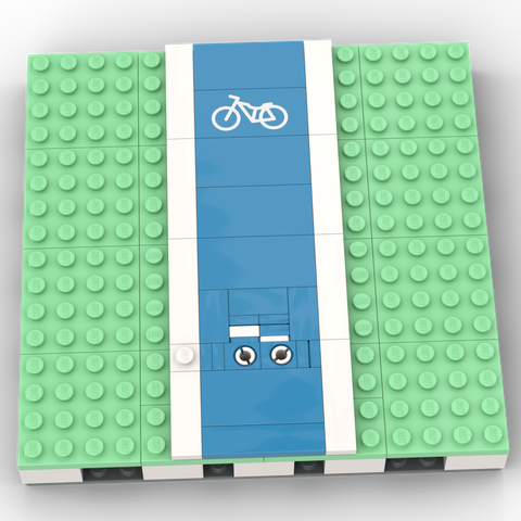
I don’t currently have the parts to make this myself, but I enjoyed spending a couple of hours this evening working out how to make a ‘brick-built’ cycle-lane symbol using ‘SNOT’ (studs-not-on-top) techniques
It’s not perfect, and there is a printed cycle-lane tile available
Pros for the printed tile: it looks more like a bicycle, and it doesn’t require the full depth of a MILS (modular integrated landscaping system) plate
Pros for my brick-built design: I made it myself, and it has a charming home-made look. 😀 And it has a basket! Also, it probably comes in the colour of your cycle lane, unlike the printed one, which is only available in dark azure
👉🏻 Can you work out how I made it? [Hint: the useful stud on the white line at the left is essential]
Is it just me, or do other people think of ET when they look at my one? 😂
I’ve just built five MILS* plates using LEGO bricks and plates on *whispers* non-LEGO bases
I was going to deviate from the standard a little by building on 32×32 plates (not *baseplates*) made by Strictly Briks, based on a YouTube recommendation: https://www.amazon.co.uk/dp/B01MTK34XU/
But I’d already ordered some regular-thickness (i.e. thin) baseplates made by Wange: https://www.bluebrixx.com/en/accessories/101246/WAN-8806-Blue-Plate-32x32-Blue-Wange
So I thought I’d try building one MILS plate on a Wange baseplate too, for comparison
It turns out that the Strictly Briks plates, though thicker (and buildable-under too!) result in MILS plates that don’t sit flat, with a slightly concave top surface
The Wange-based MILS plates are much flatter (though not completely undistorted, but I’m happy enough)
Not having used the (much costlier) LEGO baseplates, I can’t compare directly with them, and wonder whether they are subject to similar distortions
Anyone have any insights?
*Modular Integrated Landscaping System: http://www.abellon.net/MILS/

📍: Lock 4, Saltford Lock
ℹ️: lock
🗺: https://www.openstreetmap.org/?mlat=51.4096923557964&mlon=-2.44308144450828#map=17/51.4096923557964/-2.44308144450828
📸: Photo by velodenz on Flickr https://www.flickr.com/photos/8067411@N07/9097082140
#canal #river #narrowboat #barge #gongoozler #england #uk #flickr #d7000 #digital #pic #picture #phot #photo #photograph #photography #avon #tree #woods #forest #water #nature #light #boat #boatyard #bristol #boats #saltford #kelston #mils #weir #jolly #sailor #mygearandme #nikon #nikond7000 #digitalimage #dxopureraw #dxo #pureraw #d7000awtggrouping


