Eek, Mapillary map down.
Any Mapillary people here?

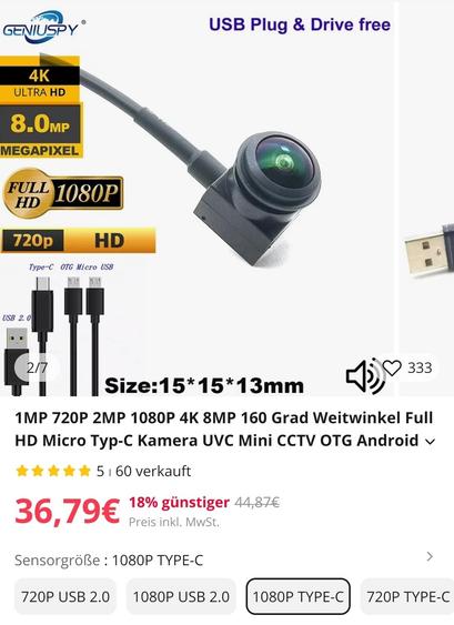
We have these cheap and compact USB-C UVC compliant cameras, but neither of the Android apps for #mapillary, #mapilio, or #KartavView support the use of external cameras. A bummer.
Very cool.
What are the differences between #panoramax and #mapillary in terms of features, use cases, viability, etc.? In #opensource, there are often overlapping tools, which can make it hard to know how to choose one (or why to choose two!).
Just trying to figure out which I should focus on.
Wikidata Taiwan 社群與 #OpenStreetMap 臺灣社群每年定期舉辦的街景踏察團,每年都上傳超過 10 萬張照片到 #Mapillary 等不同街景平台。
而這些圖片同樣以開放授權釋出,因此也同時可以將這些照片轉進到 #Wikipedia 、#Wikidata 以及 #Wikivoyage 等不同平台上,擴大整體資料的應用與再應用。
這篇文跟大家分享如何透過 WikiShootMe! 這個平台來增補維基媒體平台上面的空缺,並在 Mapillary 上面尋找其他社群參與者貢獻的照片,讓你也能在雲端進行維基各平台的貢獻!

I just discovered #JoseMonkey who tries to find people's location based on their videos.
In his latest video (https://youtu.be/oxa5e7W8nfM) he couldn't see a specific location as Google Street View didn't go that far down the path. He also had to ask a viewer to visit the location to check a memorial inscription on a bench.
Had he used #OpenStreetMap instead, he could have solved this more easily. #Mapillary has imagery all along the path, and the bench (and inscription) are in the #OSM database.

Ich glaube https://www.mapillary.com hatte mal Streetview-Daten mit offwner Lizenz, abe sehr lückenhaft. Keine Ahnung, was daraus inzwischen geworden ist... #mapillary #opendata
Some Mapillary images in Norway are quite "yeah, what I'd expect from Norway".
Reposted from @prithvignya.jntuh Instagram:
Our inaugural event PRITHVIGNYA was successfully completed.
Heartfelt thanks to Mr. Pawan Muddu and #UNMappers for their support and inspiration.
#UNMaps #UNMappers #openstreetmap #everydoor #mapillary #techfest #jntuh #mapping #gis #prithvignya #UNvolunteering #UNVolunteers #volunteering