I recently learned of this #JS library that works with #LeafletJS, @openlayers, or @maplibre to modify the most popular #OpenStreetMap-based raster tilesets to comply with strict Indian laws about depicting #India’s 🇮🇳 borders.

Sinh viên xây dựng mạng lưới an toàn phi tập trung cho du khách bằng Gemini AI và Leaflet.js! Tính năng chính: định vị địa lý trực tiếp, trí tuệ nhân tạo.context, giao thức hoảng sợ và đăng nhập blockchain #AnToanDuKhach #GeminiAI #Leafletjs #DecentralizedSafetyGrid #DuLịchAnToàn
while exploring @geopandas docs I learned it has a "explore()" function that creates an interactive #leafletjs map of the #geodataframe #pandas #gis #geodata #gischat #geopandas
https://geopandas.org/en/stable/docs/user_guide/interactive_mapping.html
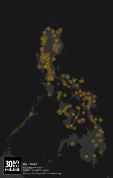
#30DayMapChallenge 🗺️ Day 1️⃣: Points
Third year participating! 🎉
I guess I’m starting the tradition of using the same map style for Day 1 that I did for 2023¹ and 2024². So here’s a map of all the cities and towns in the #Philippines that have Spanish names of saints because November 1st is All Saints’ Day³.
All map data come from #OpenStreetMap and rendered using @leaflet. 🧵 1/2
¹ https://en.osm.town/@seav/111335116974296246
² https://en.osm.town/@seav/113406977426469562
³ https://en.wikipedia.org/wiki/All_Saints'_Day
Leaflet, роутинг и тонна JavaScript: создаем свой планировщик маршрутов с нуля
Всем привет! Я, как и многие здесь, не только программист, но и большой любитель активного отдыха. Велосипед, походы, горы — все это требует тщательного планирования. И хотя существует множество отличных сервисов, мне всегда хотелось чего-то большего: платформы, которая объединяла бы в себе гибкий инструмент для создания маршрутов, базу знаний о интересных местах и сообщество единомышленников. Так я начал в одиночку создавать The Peakline — свой большой проект для аутдор-энтузиастов. Одной из центральных и самых сложных частей этой системы должен был стать планировщик маршрутов . Я решил сделать его максимально функциональным и открытым, чтобы он стал витриной возможностей всего проекта.
https://habr.com/ru/articles/946604/
#javascript #leaflet #leafletjs #openstreetmap #opensourse #gpx #gis #навигация #strava #maps


A small #Folium example. Code at: https://github.com/villares/sketch-a-day/tree/main/2025/sketch_2025_07_13
More sketch-a-day: https://abav.lugaralgum.com/sketch-a-day
If you like this, support my work:
https://www.paypal.com/donate/?hosted_button_id=5B4MZ78C9J724
https://liberapay.com/Villares
https://wise.com/pay/me/alexandrev562 #python #cartograhy #maps #leafletjs
More sketch-a-day: https://abav.lugaralgum.com/sketch-a-day
If you like this, support my work:
https://www.paypal.com/donate/?hosted_button_id=5B4MZ78C9J724
https://liberapay.com/Villares
https://wise.com/pay/me/alexandrev562 #python #cartograhy #maps #leafletjs
Generating maps with Folium is SO much easier than working with Leaflet.js directly in JavaScript. Highly recommend! #folium #leafletjs https://python-visualization.github.io/folium/latest/#
Finally! @leaflet, the venerable lightweight JS tilemap display library, is gearing up for a 2.0.0 release! 🎉
🇵🇹 Tutorial de introdução ao Leaflet 🇧🇷
🗺️ Quer aprender cartografia interativa com #LeafletJS?
Publiquei um **tutorial completo e progressivo**, ideal para iniciantes:
✔️ Camadas e controle de exibição
✔️ Dados GeoJSON
✔️ Popups e ícones personalizados
✔️ Mini-projeto final com publicação online
👉 Acesse aqui: https://www.sigterritoires.fr/index.php/pt
Blog – Português | Blog SIG & Territórios
SIG & Territoires é o portal para profissionais de GIS. Ele oferece informações sobre as mais recentes tecnologias GIS, treinamento e recursos para profissionais do setor. SIG & Territoires é o ponto de partida ideal para profissionais que desejam saber mais sobre GIS e como usá-lo para melhorar suas atividades. Por que damos preferência ao