Kazakhstan Launches High-Resolution Weather Forecast Powered by Supercomputer

Kazakhstan Launches High-Resolution Weather Forecast Powered by Supercomputer
Theo Cục Khí tượng Thủy văn, các dự báo thời tiết có tính chất cảnh báo sớm và không thể chi tiết hóa cho từng bộ, ngành hay từng quận, huyện. Các cơ quan phải tự căn cứ trên các bản tin chung để đưa ra quyết định trong phạm vi quản lý của mình.
#KhíTượngThủyVăn #DựBáoThờiTiết #CảnhBáo #ViệtNam
#WeatherForecast #Hydrometeorology #Warning #Vietnam

Theo lãnh đạo Cục Khí tượng thủy văn (Bộ NN&MT), dự báo khí tượng thủy văn có tính chất cảnh báo sớm, không thể chi tiết đến từng bộ, ngành hay từng quận, huyện. Các cơ quan phải căn cứ trên bản tin để ra quyết định trong phạm vi quản lý của mình.


"Using a metric of ‘hydroclimate whiplash’ ... global-averaged subseasonal (3-month) and interannual (12-month) whiplash have increased by 31–66% and 8–31%, respectively, since the mid-twentieth century. Further increases are anticipated... including subseasonal increases of 113% and interannual increases of 52% over land areas with 3 °C of warming..."

Rapid transitions between extreme wet and extreme dry conditions — ‘hydroclimate whiplash’ — have marked environmental and societal impacts. This Review outlines observed and projected changes in hydroclimate whiplash, suggesting that subseasonal and interannual volatility will increase markedly with ongoing warming.


This study aims to assess the potential impacts of climate change on hydrometeorological variables and drought characteristics in the Ethiopian Bilate watershed. Climate projections under two Representative Concentration Pathways (RCP4.5 and RCP8.5) were obtained from the Coordinated Regional Downscaling Experiment (CORDEX) Africa for the near future (2021–2050) and far future (2071–2100) periods. The Soil and Water Assessment Tool (SWAT) model was applied to assess changes in watershed hydrology with the CORDEX-Africa data. The Standardized Precipitation Index (SPI), Streamflow Drought Index (SDI), and Reconnaissance Drought Index (RDI) were calculated to identify the characteristics of meteorological, hydrological, and agricultural droughts, respectively. Due to a significant rise in temperature, evapotranspiration will increase by up to 16.8% by the end of the 21st century. Under the RCP8.5 scenario, the annual average rainfall is estimated to decrease by 38.3% in the far future period, inducing a reduction of streamflow of up to 37.5%. Projections in reduced diurnal temperature range might benefit crop growth but suggest elevated heat stress. Probabilities of drought occurrence are expected to be doubled in the far future period, with increased intensities for all three types of droughts. These projected impacts will exacerbate water scarcity and threaten food securities in the study area. The study findings provide forward-looking quantitative information for water management authorities and decision-makers to develop adaptive measures to cope with the changing climate.
Hydrometeorology (Hydrology 💧)
Hydrometeorology is a branch of meteorology and hydrology that studies the transfer of water and energy between the land surface and the lower atmosphere for academic research, commercial gain or operational forecasting purposes. Whilst traditionally meteorologists and hydrologists sit within separate organisations, hydrometeorlogists may work in j...
https://en.wikipedia.org/wiki/Hydrometeorology
#Hydrometeorology #Hydrology #Oceanography #BranchesOfMeteorology

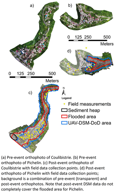


Floods are frequent hydro-meteorological hazards which cause losses in many parts of the world. In hilly and mountainous environments, floods often contain sediments which are derived from mass movements and soil erosion. The deposited sediments cause significant direct damage, and indirect costs of clean-up and sediment removal. The quantification of these sediment-related costs is still a major challenge and few multi-hazard risk studies take this into account. This research is an attempt to quantify sediment deposition caused by extreme weather events in tropical regions. The research was carried out on the heavily forested volcanic island of Dominica, which was impacted by Hurricane Maria in September 2017. The intense rainfall caused soil erosion, landslides, debris flows, and flash floods resulting in a massive amount of sediments being deposited in the river channels and alluvial fan, where most settlements are located. The overall damages and losses were approximately USD 1.3 billion, USD 92 million of which relates to the cost for removing sediments. The deposition height and extent were determined by calculating the difference in elevation using pre- and post-event Unmanned Aerial Vehicle (UAV) data and additional Light Detection and Raging (LiDAR) data. This provided deposition volumes of approximately 41 and 21 (103 m3) for the two study sites. For verification, the maximum flood level was simulated using trend interpolation of the flood margins and the Digital Terrain Model (DTM) was subtracted from it to obtain flooding depth, which indicates the maximum deposition height. The sediment deposition height was also measured in the field for a number of points for verification. The methods were applied in two sites and the results were compared. We investigated the strengths and weaknesses of direct sediment observations, and analyzed the uncertainty of sediment volume estimates by DTM/DSM differencing. The study concludes that the use of pre- and post-event UAV data in heavily vegetated tropical areas leads to a high level of uncertainty in the estimated volume of sediments.
"In this article, a new dimensionless number, the precipitation intensity duration index (PID) is presented. The world’s greatest point rainfall events, with durations ranging from 1 min to 2 years, all have nearly the same PID. One rainfall event, however, has a considerably larger PID than all others, namely, a 4-day rainfall that began on 24 February 2007 on Cratère Commerson, Réunion Island."
"4.936 m of rain fell over 4 days." ‼️
#HydroMeteorology
https://journals.ametsoc.org/view/journals/hydr/24/11/JHM-D-23-0012.1.xml
Touch typist but quickly typing "hydrometeorological" exposes some kind of fault in my wiring, or insufficiently clear and distinct synaptic recruiment. Two fingers going for the same wrong key, apparently hard to train out. 😂
I just moved to FediScience, therefore I repeat my #Introduction:
I am a #ClimateScientist at Germany’s national meteorological service (#DWD).
I am head of the department “#hydrometeorology”. We provide hydrometeorological products & services, esp. for #hydrology & #WaterManagement in #Germany, incl. assessments of #ExtremeEvents, #ClimateChange, etc.
The dep. hosts the 'Global #Precipitation #Climatology Centre' (#GPCC) & the Satellite Application Facility on #ClimateMonitoring (#CMSAF).
