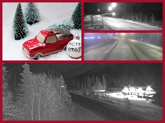
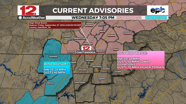
Anthony Edwards (Newsroom Meteorologist at the San Francisco Chronicle): "Ocean Prediction Center forecasts a 985 mb low tracking into Southern Oregon early Christmas Eve. That would bring significant wind to Northern California. High wind watch in effect across the Bay Area for gusts up to 60 mph.|
https://bsky.app/profile/edwardsanthonyb.bsky.social/post/3malybu5qxc2s
Ocean Prediction Center forecasts a 985 mb low tracking into Southern Oregon early Christmas Eve. That would bring significant wind to Northern California. High wind watch in effect across the Bay Area for gusts up to 60 mph. There remains considerable uncertainty with the wind forecast #CAwx #ORwx
HIGH WIND WATCH,
FROM WEDNESDAY EVE (2/12) THRU FRIDAY MORN
Southwest winds 25 to 35 mph with gusts up to 60 mph possible.
WHERE: East #SFBay & #SanFrancisco Bay Shoreline, Interior Central Coast, North SF Bay Interior Mountains & Valleys, #SantaClara Valley & Eastern Hills & #SantaCruz Mountains. #California
IMPACTS: Damaging winds could blow down trees and power lines. Widespread power outages are possible. Travel could be difficult,
especially for high profile vehicles. Strong winds may move loose debris, result in minor damage property, and cause sporadic power outages. Travel could become difficult, especially for high profile vehicles. The combination of wind and moist soils will increase the risk for downed trees.
PRECAUTIONARY/PREPAREDNESS ACTIONS: Monitor the latest forecasts and warnings for updates.
Secure loose outdoor objects that could be blown around or damaged
by the wind.
#RedFlagWarning
#WindAdvisory
#HighWindWatch
To read details from NOAA, open the map, click colored area, follow the link. Scroll down in the popup since each type of watch or warning has its own link for the details.
Latest perimeter for the #PalisadesFire shows 17,234 acres burned. Zoom in for details.
The maps has lots of #GIS layers that you can turn on/off/restack.
You can make your own custom map links that show the data you want to see.
You can change the βtopβ layer that is clickable to see attribute data.
Need help? Open the map and see 2 links upper left corner.
#EatonFire #SunsetFire #Geospatial #GISchat
Open GISsurfer map:
https://mappingsupport.com/p2/gissurfer.php?center=34.114612,-118.428497&zoom=10&basemap=USA_basemap&overlay=MODIS_7_day,VIIRS_7_day,Lake_river_stream,Perimeter_FIRIS_intel,Red_flag_warning&data=https://mappingsupport.com/p2/special_maps/disaster/USA_wildland_fire.txt
To read details from NOAA, open the map, click colored area, follow the link. Scroll down in the popup since the spot you clicked might have more than one type of weather watch/warning and each one has its own link for the details.
#CAwx
#WDEFWeather #News12Weather - In the @wdefnews12 viewing area, NE Alabama under a #WindAdvisory, SE Tennessee & western North Carolina under a #HighWindWatch for gusty winds courtesy of approaching #Helene.
Winds could make travel difficult for the area Thu PM into Fri AM.