RE: https://en.osm.town/@geofabrik/116369760352860779
#GeoPackage files from @geofabrik
Remember, geofabrik can make any data file format you want, for any area, just email `[email protected]`!
*Recursos*
Finalmente, o início de uma #documentação em @panoramax no #wiki #OSM, em vez de em páginas de fórum, que não são realmente adequadas para isso. Para se convencer disso, basta imaginar @wikipedia passando por um fórum
https://wiki.openstreetmap.org/wiki/Images_for_Panoramax:_Equipment_and_Techniques
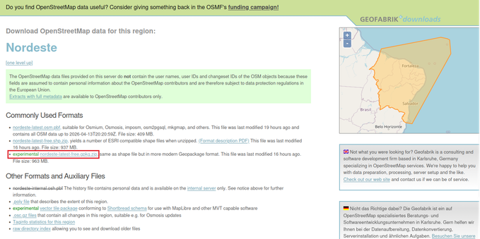
Finalmente, dados #OSM de países ou regiões disponíveis diretamente em #geopackage, graças a @geofabrik
https://blog.geofabrik.de/index.php/2026/04/07/download-server-update/

*Resources*
Finally, the start of #documentation @panoramax on the #OSM #wiki rather than on forum pages, which aren’t really suited for this. To get an idea, just imagine @wikipedia moving to a forum platform
https://wiki.openstreetmap.org/wiki/Images_for_Panoramax:_Equipment_and_Techniques
Finally, #OSM country or region data is available directly in #geopackage thanks to @geofabrik
https://blog.geofabrik.de/index.php/2026/04/07/download-server-update/

*Ressources*
Enfin un début de #documentation @panoramax sur le #wiki #OSM plutôt que sur des pages de forum, pas vraiment adaptées pour cela. Pour s’en convaincre, il suffit d’imaginer @wikipedia_fr passant sur un support forum
https://wiki.openstreetmap.org/wiki/Images_for_Panoramax:_Equipment_and_Techniques
Enfin des données #OSM pays ou régions disponibles directement en #geopackage merci à @geofabrik
https://blog.geofabrik.de/index.php/2026/04/07/download-server-update/


RE: https://en.osm.town/@geofabrik/116369760352860779
#GeoPackage files from @geofabrik
Remember, geofabrik can make any data file format you want, for any area, just email `[email protected]`!
Clip and Reproject CORINE Land Cover Data in QGIS

Store Data, Styles and Project in a GeoPackage with QGIS

The reason I made a sample dataset was that I thought it was a bit sluggish querying the GeoPackage file from DuckDB. The query in the image took 2.56 s on the GeoPackage file. I now tried to save the entire dataset into a Parquet file (sorted on county and municipality) and compressed with ZSTD. The same query takes 0.0140s.
Also the Parquet file is 141 MiB compared to 1.18 GiB for the GeoPackage file. The Parquet file is smaller than the original zip file with the GeoPackage file.

A new no-fuss way to visualize your vector data and rasters right in the #terminal: viewinline is a lightweight #Python utility by Keiko Nomura that renders #GeoTIFF-s, #GeoPackage-s, #GeoJSON-s, and #Shapefile-s instantly in #iterm2 (and other compatible terminals).

Maphub.co launches #GeoCloudConverter, a browser-based #WASM tool that transforms common geospatial file types — #GeoJSON, #Shapefile, #KML, #GPX, CSV, #GeoPackage, or #GeoTIFF – into modern, #cloudnative formats like #GeoParquet, #FlatGeobuf, #PMTiles, or Cloud-Optimized GeoTIFF (#COG). The tool performs all processing locally in your browser for quick, private conversions up to 1 GB.