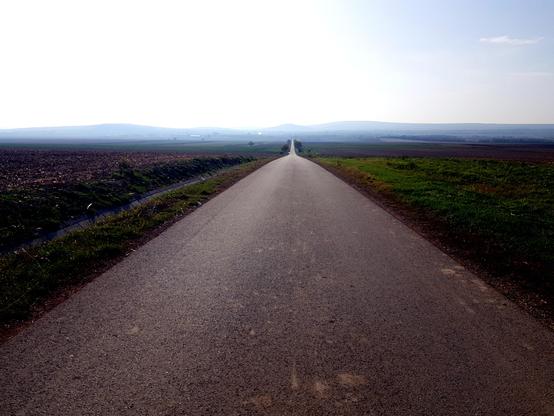
Boderadweg Egeln -Gänsefurth - Richtung Athensleben
Egeln-Gänsefurth cycle path - towards Athensleben
#cyclepath #boderadweg #bode #flussradweg #sachsenanhalt #landscapephotography #outdor
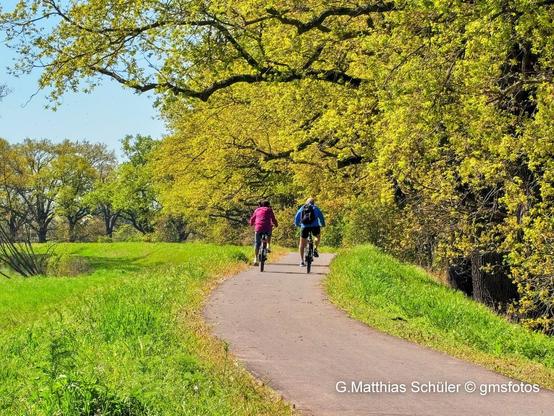
Boderadweg Egeln -Gänsefurth - Richtung Athensleben
Egeln-Gänsefurth cycle path - towards Athensleben
#cyclepath #boderadweg #bode #flussradweg #sachsenanhalt #landscapephotography #outdor

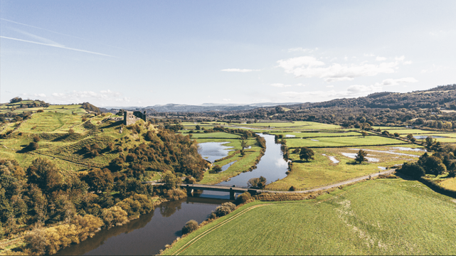
EASTER OPENING: Final stretch of Tywi Valley Path set to welcome walkers and cyclists
Carmarthenshire County Council has confirmed the final stretch of the Tywi Valley Path — linking Carmarthen to Llandeilo — will be ready for the public within weeks.
The last section of the 13-mile route, between Abergwili and Ffairfach, marks the completion of the flagship project.
Landmark bridges complete final phase
The final phase includes two major new bridges crossing the River Tywi and River Cothi — described as a key milestone in delivering the scheme.
Once open, the route will provide a continuous, traffic-free path for walkers, cyclists and families travelling through the Tywi Valley.
Scenic route through historic heart of Wales
The path runs through some of Carmarthenshire’s most picturesque countryside, offering views of landmarks including Paxton’s Tower, Dryslwyn Castle and Dinefwr Castle.
Visitors will also be able to explore nearby attractions such as National Botanic Garden of Wales and Aberglasney Gardens, along with independent food stops and cafés along the route.
Boost for tourism and local economy
Council leaders say the completed path will help bring more visitors to the area while supporting local businesses.
Cllr Hazel Evans said the scheme was a “once in a generation project” that connects communities while showcasing the valley’s natural beauty and heritage.
Cllr Edward Thomas added that completing the bridges provides “a stunning new way to experience the county” while supporting active travel and tourism.
Years in the making
The full opening follows years of development, including major funding backing and the phased rollout of different sections of the route.
When complete, the Tywi Valley Path will stretch from Carmarthen to Llandeilo, offering a safe and accessible route for residents and visitors alike.
Related stories from Swansea Bay News
Consultant appointed to progress Llandeilo bypass
A major step forward for the long‑awaited route around the town.
Four‑mile section of Carmarthen–Llandeilo cycle path opens
A key stretch of the Tywi Valley route is now ready for riders.
Tywi Valley communities asked for views on new woodland
Residents invited to help shape a major commemorative planting project.
Tywi Valley Path gets £16.7m Levelling Up boost
A huge funding injection accelerates plans for the scenic route.
Rad-Highway Nord Teil 3 | Beradelungen Wien 2025

Winter Tour - Day 3: Montpellier -> Marseillan (55 km).
After a rainy and windy day spent in Montpellier to visit the outstanding Musée d'art brut, today back on the road facing strong headwind. A few flamingos next to the very nice #cyclepath of Étang de Thau.
#BikeTooter #cycling #bikepacking #radtouren #fahrrad #cyclotourisme #vélo #bici #cycle #radfahren #radtour #bike #bicycle #Brompton


Winter Tour - Day 2: Pondres -> Montpellier (45 km).
Again mostly on superb #cyclepath. Arrival in a big city such as Montpellier always a choc, even if there are many cyclepath as well. On the way the village of Sommières was charming (see picture).
#BikeTooter #cycling #bikepacking #radtouren #fahrrad #cyclotourisme #vélo #bici #cycle #radfahren #radtour #bike #bicycle #Brompton


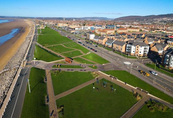
Major revamp planned for Sandfields and Aberavon as council unveils huge active travel upgrade
The £multi‑million scheme covers a 4.7km stretch linking the seafront with Afan Way, creating a continuous loop designed to make everyday journeys safer and easier without needing a car. Council officers say the project will tie directly into the wider Aberavon Seafront Masterplan, bringing long‑term improvements to some of the area’s busiest routes.
The plans include upgraded footways, new cycle lanes, safer crossings, resurfaced roads, better bus facilities and a series of public‑realm makeovers at key community hotspots. A consultation has now opened, with residents given until 11th March to give feedback.
The council says the work is vital in a community where official data shows fewer than half of households own a car, making safe walking and cycling routes essential for school runs, shopping trips and access to the beach.
Years in the making
The project has been in development since 2022, when a study identified ten Sandfields routes in need of upgrades. Early engagement followed in 2024, with residents helping shape the first designs for three priority corridors: Princess Margaret Way, Victoria Road and the Seaway Parade–Handel Avenue–Purcell Avenue loop.
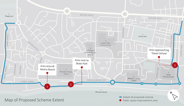
By 2025, the scheme had expanded to include placemaking improvements around Memo Beach Café, the skate park, Tywyn Primary School and Purcell Avenue, with drop‑in sessions held last autumn to gather ideas. Detailed designs are now nearing completion, and the council is preparing a funding bid through the Regional Transport Fund to begin construction in 2026–27.
Map showing the proposed Sandfields and Aberavon active travel route, including planned public‑space upgrades around Memo Beach, the skate park and Tywyn Primary School.What’s planned on the ground
If approved, the scheme will deliver new and widened footways, resurfaced pavements and missing links such as the broken section near the Naval Club. Dedicated cycle lanes are proposed for Princess Margaret Way, with on‑road routes added to nearby residential streets to create a safer network.
Eight new Toucan crossings and five new Parallel crossings are planned for some of the area’s busiest junctions, alongside more than 50 upgraded uncontrolled crossings with dropped kerbs and tactile paving. Bus users would see new shelters and a relocated stop opposite Remo’s to support revised routes along the seafront.
Public spaces are also set for a facelift, with new seating, planting, surfacing and landscaping around Memo Beach, the skate park and Tywyn Primary School. Additional greenery and pocket planting would be added throughout the area to soften the streetscape.
Parking changes include new loading bays near Francos and Memo Café, extra disabled bays and a small net increase in overall parking along the seafront. Measures to stop pavement parking — including bollards, planting and double yellow lines — are also proposed.
Princess Margaret Way would be fully resurfaced as part of the works.
“A good balance of improvements for everyone”
Cllr Wyndham Griffiths, Cabinet Member for Strategic Planning, Transport and Connectivity, said the plans strike the right balance for a community with low car ownership but high demand for safer routes.
“I strongly encourage anyone who lives in or visits these areas to have their say on the proposals which would offer improved safety and better‑connected routes, whilst also lifting the overall appearance,” he said.
How to take part
The consultation runs until 11th March 2026, with residents able to complete the survey at www.npt.gov.uk/activetravel.
Two face‑to‑face drop‑in events will be held at Aberavon Leisure Centre on Monday 2nd March (3pm–7pm) and Saturday 7th March (10am–1pm), where the project team will be available to answer questions.
Paper copies of the plans and survey are available at Sandfields, Port Talbot and Neath libraries.
Related stories from Swansea Bay News
Major overhaul planned for Llanelli’s Halfway lights
Another major transport scheme proposing safer crossings, new layouts and better routes for all road users.
Swansea’s future mapped out in new city centre plan
A look at the wider regeneration vision shaping movement, public spaces and development across the city.
Upper Afan Valley lined up for £20m regeneration boost
Long‑term investment plans aimed at transforming communities and improving connectivity across the valley.
Bulldozers move in as Aberavon flats set for dramatic revamp
Another key project reshaping the seafront, linked to wider regeneration and public‑realm improvements.
#Oxford Marston #cyclePath update from
@marstonbikepath
The cycle track is still clear at the moment.Although I don't know for how much longer. Standing water in the meadows on both sides of the track.
--Rhodri