🧠 CCCA-Wissenssnack: Ernährung
Better eat your veggies!💚🥕
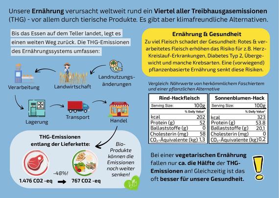
Was wir essen, beeinflusst nicht nur unsere Gesundheit, sondern auch das Klima. Rund ein Viertel der weltweiten Treibhausgasemissionen stammt aus dem Ernährungssystem – insbesondere aus der Produktion tierischer Lebensmittel.
Eine fleischlastige Ernährung erhöht zudem das Risiko für Herz-Kreislauf-Erkrankungen, Typ-2-Diabetes, Übergewicht und bestimmte Krebsarten.
In Österreich liegt der Fleischkonsum etwa dreimal so hoch wie von der Österreichischen Gesellschaft für Ernährung empfohlen.
🌱 Eine pflanzenbetonte Ernährung senkt nicht nur Gesundheitsrisiken, sondern kann auch rund die Hälfte der Treibhausgasemissionen einsparen.
📬 Die CCCA-Wissenssnacks bieten im handlichen Postkartenformat verständliche Einblicke in vielfältige klimarelevante Themen – kompakt, wissenschaftlich fundiert und mit weiterführenden Informationen.
👉 Mehr Infos und weitere Wissenssnacks findet ihr hier:
https://ccca.ac.at/wissenstransfer/wissenssnacks
#CCCA #ClimateChangeCentreAustria #CCCAWissenssnack #ClimateCrisis #Wissenschaftskommunikation #Klima #Climate #Klimawandel #SDG3 #SDG6 #SDG11 #SDG13 #SDG14 #SDG15
@klimafonds