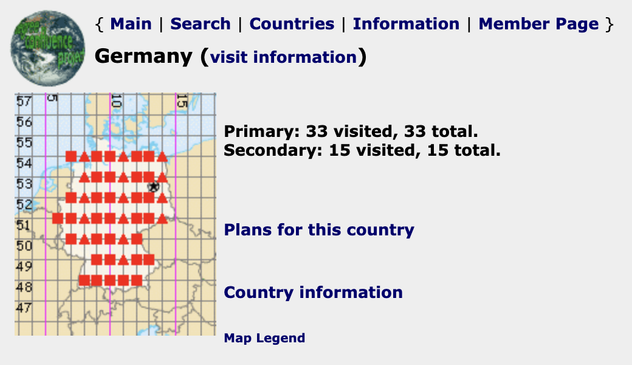
Zusammenfluß: Konfluenzpunkte / Confluence: Confluence points https://geoobserver.de/2026/06/10/zusammenfluss-konfluenzpunkte/ #gistribe #gischat #fossgis #foss4g #OSGeo #spatial #geospatial #mapping #gis #geo #geoObserver pls RT
Exploring Tools in #ArcGIS #Data Pipelines https://tinyurl.com/3tvrx8e8
#ETL #DataMgmt #GIS #esri #GISchat #geospatial @esri @esrifederalgovt @esrislgov @arcgisonline @arcgisxprise @esritraining
PHEW! #sotmus26 workshop materials wrapped up. Ready to geek out about JOSM and admin boundaries.
See you there?
RE: https://mapstodon.space/@CaGIS/116329792287374702
Check out the CaGIS Interview with Mahdi Nazari Ashani to hear all about running a SLM in a browser https://youtu.be/YZ-BFNHtwMo and checkout the full demo of AWebGIS at https://youtu.be/7-QYALy4F2E plus the CaGIS article for #free at https://doi.org/10.1080/15230406.2026.2625987 #GISchat
Try the #ArcGISPro assistant 3.7 beta https://tinyurl.com/3a8vsryv
#AI #help #GIS #esri #arcgis #mapping #GISchat #geospatial @esri @arcgispro @esrifederalgovt @esrislgov @esritraining @urisa


Simon Poole has compiled an overview of Swiss cantonal #opendata by #licence type: which “access authorisation level A” datasets are truly #open and which are compatible with #OpenStreetMap. Separately, a weekly-updated monitor tracks the openness and availability of all cantonal geodata on geodienste.ch.