It is a common belief that higher elevations are naturally cooler. In pristine landscapes, this rule holds firm. But what about urban environments? Humanity moves vast amounts of matter and energy, sometimes fundamentally altering the thermodynamic parameters of our habitat.
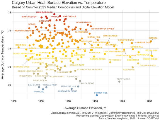
🛰️ I correlated summer Land Surface Temperature (LST) data across Calgary’s neighborhoods with the Canadian Medium-Resolution Digital Elevation Model (MRDEM). The chart below illustrates the relationship between "Average Elevation" and "Average Surface Temperature" specifically for established residential communities. As observed, this relationship is notably weak, even though a slight cooling trend persists. Based on my data analysis, elevation above sea level is not a key factor in cooling the city.
#Calgary #OpenData #UrbanHeat #DataScience #ClimateAction #YYC #GreennesOfCalgary #ClimateEquity #EnvironmentalEquity #CityPlanning #RemoteSensing #RStats #Landsat #fossgis #DigitalElevationModel