A question: Is the #CyclOSM map layer for #OpenStreetMap currently down?
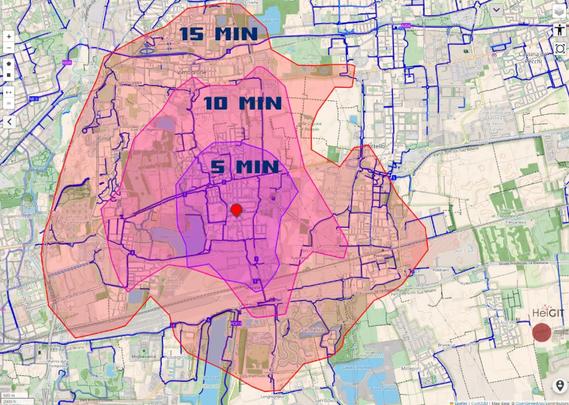
In #bici si può raggiungere il centro di #Segrate da tutto il comune in meno di 15 minuti, e non serve parcheggio.
Grazie a #openrouteservice è possibile visualizzare una mappa della raggiungibilità (sotto il link). Si vede che tutto il territorio di Segrate, che non è piccolo, si comunque girare facilmente in bici. Con l'aiuto di #cyclosm si possono identificare i percorsi ciclabili per programmare gli spostamenti.
#inBiciEMeglio, provare per credere!
Anteriormente, he comentado que me encanta la app #OsmAnd en el móvil, especialmente para ir en bici o senderismo. Mi perfil favorito para la bici en OsmAnd es #Cycloroute y no esta preinstalado por defecto.
Aunque es muy fácil he hecho un vídeo explicando como hacerlo (tb como usar #CyclOSM como"sobrecapa") y mostrando el aspecto del perfil. En la descripción del vídeo hay +info, y los enlaces relacionados.
https://urbanists.video/w/fmZHJmwpvcVyA9z1k8KZtM
#OpenStreetMap
OsmAnd: Instalando y mostrando el perfil para bicis Cycloroute
I have mentioned several times that I love #OsmAnd for the mobile, specially for cycling or hiking. Nevertheless, my OSMAND favourite bicycle profile is #Cycloroute which is not available by default.
Despite it's pretty straight forward I explain how to in this video (also how to set #CyclOSM as an overlayer) and I show the profile. In the description video you can find all the related links, including the one to download the profile.
https://urbanists.video/w/xAb9twJoiGYV3S9JqS64RL
#OpenStreetMap

OsmAnd: Install Cycloroute profile
OsmAnd: Instalando y mostrando el perfil para bicis Cycloroute
OsmAnd: Instalando y mostrando el perfil para bicis Cycloroute
OsmAnd: Install Cycloroute profile
OsmAnd: Install Cycloroute profile
Sime time ago I mentioned of a #OsmAnd profile I find quite useful for cycling. The profiles called #CycleRoute is partially inspired in #CyclOSM & is described here:
https://github.com/OsmAnd-Rendering/Cycling/blob/eb217c66b1d7ac858f6f289e232b6c6591011867/README_EN.md
Here u can find the instructions to install this and other profiles (for example a hiking profile):
https://github.com/OsmAnd-Rendering/.github/wiki/
It is pretty straightforward downloading a file, opening with OsmAnd and importing the profile.
I like to have as default this profile with a CyclOSM overlay as shown in the pictures
Sometimes I have suggested that OSMAND is a quite useful tool, among other things to move cycling (as it is based in #OpenStreetMap and besides being free it is much better than GMaps when cycling, walking, hiking, etc.). But i want to suggest two useful tools:
1) A link to OpenStreetMap showing it as #CyclOSM: https://www.openstreetmap.org/#map=16/37.61115/-0.98467&layers=Y

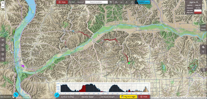
The developers of https://sherpa-map.com announced [0] their "best gravel/cycling focused Map to route you adventures on", based on #OpenSteetMap data and inspired by #CyclOSM [1].
The map has been rendered globally, but the following regions are usable down to zoom level: 16
#UnitedStates
#Japan
#Philippines
#Taiwan
#Canada
#Australia
#Europe
#Alaska
#Hawaii
[0]: https://www.reddit.com/r/openstreetmap/comments/1db5ey7/i_spent_6_months_creating_the_best_gravelcycling/
[1]: https://github.com/cyclosm/cyclosm-cartocss-style/blob/master/docs/DOCKER.md
Since many other services such as Strava, Ride With GPS, and CyclOSM rely on OpenStreetMap data, this results in better bike routes for everyone!
It's gamified mapping and is oddly addictive. I've already noticed an improvement in recommended Strava routes in my area and it's been easier to create routes manually by looking at the improved CyclOSM maps.
#StreetComplete #OpenStreetMap #OSM #CyclOSM #Cycling #Guelph #Bikes #Strava #RideWithGPS #OpenSource