Great fun with FLIR and learning about wind chill here:

Great fun with FLIR and learning about wind chill here:
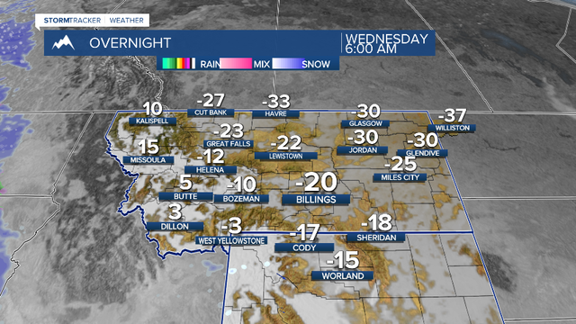
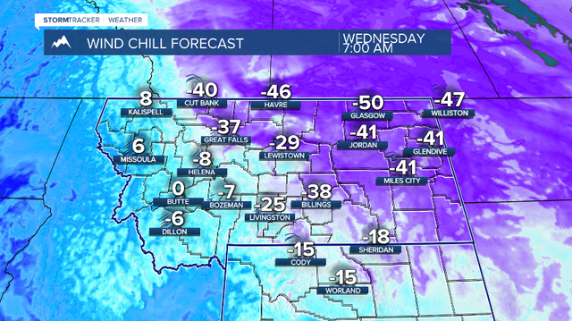
After 60 straight hours of snow (and 11 new inches!), it's hit a red light. We'll be VERY cold Wednesday morning with lows of -15° to -35° and wind chills of -35° to -55°. A warm-up IS coming... hang on!
#Montana #Billings #snow #cold #windchill #dangerous #Tuesday #Wednesday #weather #mtwx
Going to be 50 degrees today near Redmond WA and no rain. Sweet. We will be walking in the Redmond Watershed this afternoon. Wave when you see us.
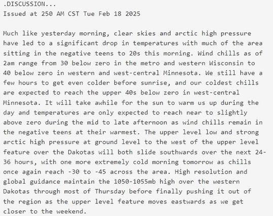
Meanwhile, not quite so balmy in much of the country. The text screenshot is from NOAA’s forecast discussion for the area that includes Minneapolis and St. Paul.
To read forecast discussions for other areas, open the map, click inside any red-outlined area and follow the link. #WindChill
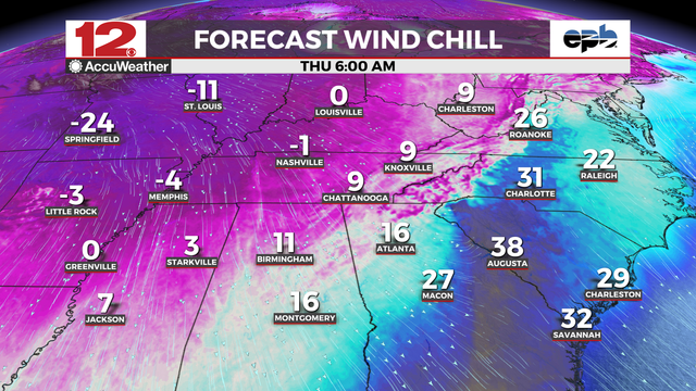
#ExtremeColdWarning extends deep into #Texas including #Dallas and #FortWorth areas. Too bad Texas has a goofy electrical system that screws consumers. #TXwx
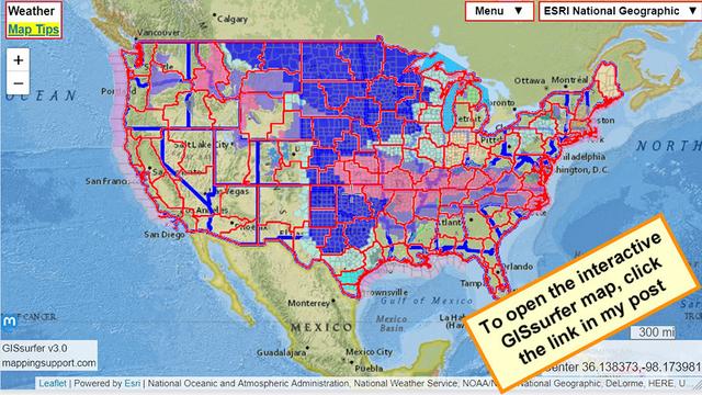
To read the weather watch and warning details from NOAA - including timing - open the map, click colored area, follow the link. Since the spot you clicked might have more than one type of watch/warning, scroll down in the popup since each type of watch or warning has its own link for the details. #WindChill
Open #GISsurfer map:
https://mappingsupport.com/p2/gissurfer.php?center=37.196232,-97.734718&zoom=4&basemap=ESRI_National_Geographic&overlay=State_boundary,Weather_watch_warning&data=https://mappingsupport.com/p2/special_maps/disaster/USA_weather.txt
These bison are built to handle heavy snow, brutal cold and dangerous wind chills, and we in Montana are used to it, but if you can stay safe at home and off the roads, it's better for everyone! More snow and cold ahead!
#Montana #bison #snow #cold #windchill #staysafe #soundon #Monday #winter #weather
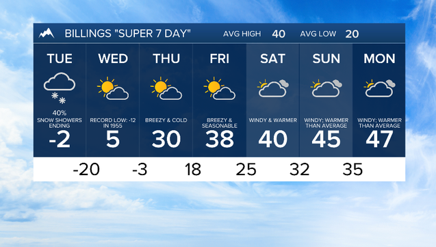
It's very cold and very snowy in Montana right now. Billings is -5 with a wind chill of -23 at 8AM, but northeast Montana is between -30 and -40 with wind chills of -45 to -55. Please stay safe, warm and dry... the snow will continue through tomorrow, and then it will get even colder.
#Montana #Billings #Q2 #KTVQ #MTN #Wyoming #snow #cold #windchill #weather
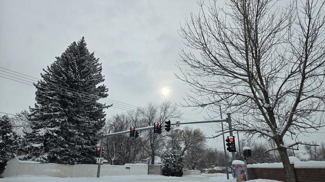
Nope, not spring yet.
#WindChill in the upper midwest reminds me why I do not live there anymore. Snorkel parka anyone? See the screenshot for 'Extreme Cold Warning'.
And when was the last time you saw a #HighWindWarning for Washington #DC? If only it would blow hard enough to clean out #DictatorTrump and his goons.
To read the weather watch and warning details from NOAA - including timing - open the map, click colored area, follow the link. Since the spot you clicked might have more than one type of watch/warning, scroll down in the popup since each type of watch or warning has its own link for the details.
Open #GISsurfer map:
https://mappingsupport.com/p2/gissurfer.php?center=37.196232,-97.734718&zoom=4&basemap=ESRI_National_Geographic&overlay=State_boundary,Weather_watch_warning&data=https://mappingsupport.com/p2/special_maps/disaster/USA_weather.txt
