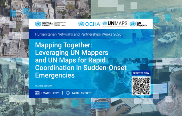
UN Maps will join the Humanitarian Networks and Partnerships Weeks - #HNPW2026

On 5 March | 14:00–15:30 UTC, we are hosting a remote session: “Mapping Together: Leveraging UN Mappers and UN Maps for Rapid Coordination in Sudden-Onset Emergencies.”

This session will examine how #UNMaps and the #UNMappers community strengthen coordination and decision-making during sudden-onset emergencies.

Be part of the discussion: http://www.hnpw.org/

#opendata #drrm #openmapping #unitednations #ungsc

From 1 to 4 December 2025, United Nations Global Service Centre (UNGSC), in collaboration with the UN Office of Information and Communications Technology (UN OICT) and the UN Geospatial Network, organized the UN Maps Clinic sessions remotely. 🌐🗺

Read more 👉 https://maps.un.org/news/4th-annual-conference-un-maps-clinics-enhancing-un-maps-field-field

#UNMapsConference #unitednations #geospatial #UNMaps #UNMappers #openstreetmap #GIS #peacekeeping #UNGSC #cartography #opendata #maps #UNgeospatial #mapping #mapservices #UNGeospatialNetwork

Mr. Kais Zouabi, Chief of Client Solutions Delivery Section, formally closed the conference with deep gratitude to the organizers and participants, and celebrating how far the community has come and looking confidently toward the shared roadmap ahead.

#UNMapsConference #unitednations #geospatial #UNMaps #UNMappers #openstreetmap #GIS #peacekeeping #UNGSC #cartography #opendata #maps #UNgeospatial #mapping #mapservices

In the closing session, Mr. Anthony O’Mullane, Director of the Policy, Strategy and Governance Division, United Nations Office of Information and Communications Technology, delivered a keynote address highlighting the potential of open-source technologies, the importance of local data ecosystems, and the growing recognition of GIS as an enterprise enabler.

#UNMapsConference #unitednations #geospatial #UNMaps #GIS #peacekeeping #UNGSC #opendata #maps #UNgeospatial #mapping #mapservices

🎯 Mr. Diego González Ferreiro, Chief, Solutions & Support Unit, and Ms. Laura Diaz, Chief, Data Management Unit, led the co-creation session aiming to outline the definitive implementation roadmap and the proposed path forward after the #UNMaps Clinics.

#UNMapsConference #unitednations #geospatial #UNMaps #UNMappers #openstreetmap #GIS #peacekeeping #UNGSC #cartography #opendata #maps #UNgeospatial #mapping #mapservices

🥽 Mr. Ignacio Vázquez Vélez, #GIS Consultant, and Mr. Ferdinando Cesaria, Computer Science Engineer, demonstrated UN Maps XR and how it transforms traditional 2D geospatial data into dynamic, interactive Extended Reality environments.

☁ Mr. Zeeshan Khan, Information Systems Officer, introduced the cloud-based infrastructure for centralized geospatial data management and analysis.

#UNMapsConference #unitednations #geospatial #UNMaps #peacekeeping #UNGSC #opendata #maps #mapping #mapservides

🗺 DAY 4 and Closing Session of the UN Maps Clinics 🗺

Today's session focused on 3D Tools and Features 💻, and Ways Forward ⏭

🌐 Mr. Javier Neme-Lozano, Chief, Visualization and Mapping Unit, presented the Digital Twins applications and explained its role in simulation, analysis, and strategic planning for operational cases.

#UNMapsConference #unitednations #geospatial #UNMaps #UNMappers #openstreetmap #GIS #peacekeeping #UNGSC #cartography #opendata #maps #UNgeospatial #mapping #mapservices

📈Mr. Pietro Di Gennaro, Computer Science Engineer, showed the UN Maps Power BI plugin for creating interactive dashboards and analytics.

🗺 Mr. Antonio Carrozzo, Geospatial Information Systems Assistant, presented the recent enhancements to the Maps on Demand application and its expanded capabilities.

Conference Agenda here: 👉 https://maps.un.org/conference/2025

#UNMapsConference #unitednations #geospatial #UNMaps #GIS #peacekeeping #UNGSC #opendata #maps #UNgeospatial #mapping #mapservices

🗺 DAY 2 of the UN Maps Clinics 🗺

Today's session focused on Geospatial Information and Mission Dashboards 🎯

🖼 Mr. Attila Szucs, Associate Geospatial Information Officer, demonstrated the Image Map feature and its integration and practical applications.

📍Ms. Laura Diaz, Chief, Data Management Unit, discussed about the Operational Map and how we maintain and utilize geodata information.

#UNMapsConference #unitednations #geospatial #UNMaps #UNMappers #UNGSC #opendata #UNgeospatial #mapservices