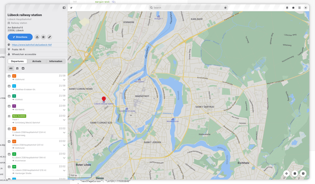
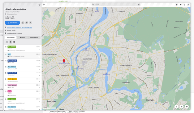
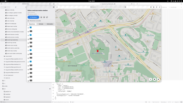
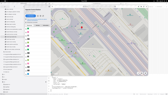
Got a bit further on the departures/arrivals view feature.

Now shows a toggle group with tranportation modes available for the selected station/stop (when there are multiple modes served at the location) allowing filtering what to show.

#gnomemaps #gnome #transitous #PublicTransport #PublicTransit #mapstodon

A few more details on the organizational work around #OpenTransport2026 and #Transitous from last week's #FOSSGIS community meeting: https://volkerkrause.eu/2026/05/09/fossgis-community-meeting-may-2026.html
FOSSGIS Community Meeting May 2026

Last weekend I joined parts of the FOSSGIS Community Meeting at Linuxhotel in Essen, Germany, focusing on topics related to organizing this year’s edition of...

Made some more progress on the implementation of the “stoptimes” API from MOTIS in Maps.
Now actually showing departures (or arrivals) in the place details when clicking on a “public transit-type“ place (station etc.), when there's data available in Transitous.
The rows still only shows the transit mode icon and line number/name (e.g. missing time, destination and so on…)

#gnomemaps #gnome #motis #transitous #PublicTransport #PublicTransit

Und vielen Dank nochmal an #transitous, MOTIS und alle anderen, die daran arbeiten, Datensets wie #OSM und Tools für öffentliche Verkehrsmittel zu verbessern.
Immerhin ist route.lw1.at größtenteils nur eine Sammlung von den besten Open Source Tools und Open Data Datasets zu einer praktischen Webseite (und ein paar kleine Verbesserungen dabei).

Eine der größten Verbesserungen, die ich zusätzlich zu #Transitous erreichen wollte, war eine Sammlung der offiziellen Farben aller Öffi-Linien in Österreich.
Um nicht noch eine neue Datenbank zu erstellen, versuche ich fehlende Daten zu #OSM beizutragen und inspiriert von #PTNA (von @ToniE) die Tabelle aus den existierenden Daten in OSM und PTNA zu generieren.

Siehe hier für mehr Details:
https://git.lw1.at/lukas/route.lw1.at/src/branch/synced/main/color-data

route.lw1.at

Personal MOTIS instance for Austrian Public Transport Data

git.lw1.at

Ich bin jetzt endlich dazugekommen, mein aktuelles Hobby-Projekt zu veröffentlichen:
https://route.lw1.at/

Seit ich letztes Jahr #Transitous (@transitous) und #MOTIS gefunden habe, wollte ich sehen, ob ich damit eine eigene Öffi-Routing Plattform machen kann. Und ob ich, indem ich mich nur auf Österreich fokussiere, die Datenqualität verbessern und somit das beste Tool für Öffi-Verbindungen in Österreich erreichen kann.

Hier gibt es mehr Infos:
https://about.route.lw1.at/
https://git.lw1.at/lukas/route.lw1.at

MOTIS

And many thanks to #transitous, MOTIS and everyone else working on related software and datasets like #OSM!
After all, route.lw1.at is essentially just me collecting everything great about Public Transport Open Source and Open Data together into one tool and fixing minor issues in the process.

One of the main improvements I tried to gather on top of #transitous is a collection of the colours of all public transport lines in Austria. To avoid creating one more database, I instead try to contribute missing information back to #OSM and inspired by #PTNA (by @ToniE), I derive the table from the existing data.

See here for more information:
https://git.lw1.at/lukas/route.lw1.at/src/branch/synced/main/color-data

route.lw1.at

Personal MOTIS instance for Austrian Public Transport Data

git.lw1.at

I finally got around to publishing my latest hobby-project:

https://route.lw1.at/

Ever since first learning about #transitous (@transitous) and #MOTIS last year, I was curious if I could make my own public transport routing platform based on them. And if by focusing just on Austria I can experiment with improving the data quality and get the best tool for finding public transport connections in Austria.

You can learn more here:
https://about.route.lw1.at/
https://git.lw1.at/lukas/route.lw1.at

MOTIS

Der @bvv kann deine Adresse öffentlich machen, aber nicht den Fakt, dass der Bus ausfällt.
#opendata #transitous #karlsruhe