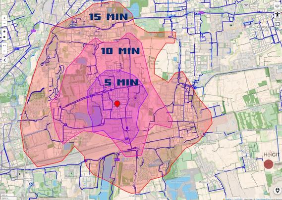
Mobilità ciclistica: a Milano è un fattore più considerato da chi cerca casa (su Immobiliare.it)

E brava immobiliare.it, che con la scusa della #giornataMondialeDellaBicicletta (il 3 giugno), si fa pubblicità, evidenziando la possibilità di cercare casa entro un certo tempo di percorrenza in bici da un punto dato:

https://www.ilgiorno.it/milano/cronaca/immobiliare-casa-e-bicicletta-rwkoppmc

A quanto pare, #Milano è il luogo dove questa caratteristica è più usata, in Italia. Non credo che sia sorprendente, vista la dimensione della città, i timidi miglioramenti sul tema #ciclabilità degli ultiminanni, e il fatto che i prezzi delle case non lascino molta scelta a chi va ad abitarci 😛.

Facendo una prova, si vede subito come con 15 minuti di bici si possa girare mezza città senza problemi (se si esclude la #violenzaStradale di quelli che vogliono arrivare prima al prossimo rosso).

Comunque se avete bisogno di isocrone, vi consiglio #openrouteservice, che permette di configurare molti parametri, senza cookie di società commerciali e misteriose terze parti. I risultati, come si vede dall'immagine, sono molto simili

https://maps.openrouteservice.org/

@milano

Day 93. Cluj-Napoca 5-minute walk 🚶

This one is intentionally small and local: how much of a city becomes reachable within roughly five minutes on foot?

The map stays centred on Cluj-Napoca and keeps the visual language simple (Three.js/WebGL), while Openrouteservice provides walking isochrones over Stamen Design tiles and OpenStreetMap data.

https://maptheclouds.com/playground/30-day-map-challenge-2022/cluj-5minutes-walk/

#100DayMapChallenge Day 93/100

#Leaflet #Openrouteservice #OpenStreetMap #Geospatial #Walkability #Urban #ClujNapoca #Romania

🚧service announcement for #openrouteservice (ORS) users🚧

As we are moving to a unified structure for all HeiGIT APIs, we are deprecating the URL https://api.openrouteservice.org. From now on, please use the new URL https://api.heigit.org.

(This is only a deprecation of the URL, not a deprecation of our services: openrouteservice remains accessible!)

More info on the openrouteservice forum: https://ask.openrouteservice.org/t/deprecating-api-openrouteservice-org-in-favour-of-api-heigit-org/7912

How can open-source routing tools support better waste collection in rapidly growing cities?

In Kenya, #openrouteservice (ORS) was used to improve planning for solid waste collection in underserved areas. APHRC organized #GIS trainings for environmental officers, introducing #QGIS, ORS, and Datawrapper.
Participants learned how to optimize waste collection routes, generate isochrone maps, & estimate travel times between collection points and disposal sites.

The project: https://heigit.org/optimizing-solid-waste-collection-in-underserved-regions-using-openrouteservice-a-pilot-study-in-kisumu-kenya/

How far is too far to reach a school or clinic?

We built OpenAccessLens, a global, open-source platform measuring physical access to education and healthcare worldwide. Powered by @openstreetmap and #openrouteservice, it maps travel-time to essential services so humanitarian orgs, planners, and researchers can act on the gaps.

Open-source. Community-driven. 🌍

👉 https://heigit.org/a-map-is-better-than-a-thousand-words-global-data-reveals-gaps-in-access-to-education-and-healthcare/

#openstreetmap #PublicHealth

The theme of week 8 of #52maps was "Reach". I made a map about how long it would take you to reach the State of the Map 2026 venue on foot. I made the 5 minute interval isochrones using the ORS Tools plugin for #QGIS that uses the #openrouteservice

More info about #52maps can be found on https://52maps.org // @52maps

#StateOfTheMap #OpenStreetMap

🚴 How bike friendly is your city, really?

A new BIKE Index compares cycling conditions across European cities using data from #OpenStreetMap and open source tools. By simulating 210 cycling routes per city with #openrouteservice, the study reveals clear differences in how well city networks support bike travel.
The Index show where cycling works well & where infrastructure slows riders down, highlighting how #open-source tools turn maps into actionable insights.

🔗 https://tinyurl.com/2jxpa2ja

How can dynamic data save lives in humanitarian crises?

When bridges collapse or floods cut critical roads, static routing becomes outdated fast, slowing down relief.

Together with Logistics Cluster, we’re developing dynamic routing that integrates real-time, mission-specific data directly into route calculations, helping responders adapt on the fly and avoid delays.

👉 Read more: https://heigit.org/rethinking-humanitarian-routing-when-every-minute-and-mile-matter/

#humanitarianLogistics #humanitarian #routing #openrouteservice

Ein kleines Sideprojekt was ich immer ein bisschen entwickeln lasse (disclaimer: das ist ein Agentic AI/KI Software Prototype) hat jetzt eine "es tut was es soll" Status erreicht: Ich darf Euch vorstellen:

Mail2Trail

ein Dienst, wo ihr für Eure #fernwandern #thruhike in .de GPX Datei des Tracks hochladen werden könnt und es im Umkreis um den Track herum DHL Paketstation heraussucht aus #openstreetmap daten, supplyboxen oder #ausrüstung hinsenden lassen könnt und euch die entfernung per #openrouteservice ermittelt. Änhlich wie bei den großen Hikes in .us (#PCT und co) mit den Post Offices des #USPS

Ich muss mal schauen das ich wen finde der da ein ordentliches Code Review zu macht, aber hier mal ein Sneak Peak: