The thread about the Forth Dam megaproject; why bridge the Firth when you can block it?

Here’s one for you that I bet you’ve probably never heard of: did you know that in 1928 there was a proposal to cross the Firth of Forth by building a dam across it? This will be a short thread, by nature of the dearth of information available, but hopefully a useful record of this bold initiative.

Forth Bridge from above [South] Queensferry. James Valentine postcard, 1890. © Edinburgh City Libraries

The scheme was the brainchild of Matthew Steele, a Bo’ness-born architect whose work focused on retail and housing, first in an Arts & Crafts and later in the Moderne style, and includes the Hippodrome cinema. In this endeavour he was joined by fellow Bo’nessite John Jeffrey; hotelier and burgh councillor.

Bo’ness Hioppodrome cinema, by Matthew Steele (top left). Picture via Visit Scotland website.

This was a time before the Kincardine swing bridge was built (not completed until 1936) and there was much public debate about the best manner and location for a road vehicle crossing of the Forth downstream of Stirling. The Firth had of course been crossed way back in the 1890s by the rail bridge.

The Kincardine Bridge, © Copyright James Allan, CC-by-SA 2.0 via Geograph

Jeffrey and Steele’s proposal was to throw a 7,300 foot long barrage (1.3 miles, 2.2km) across the Firth and lay a roadway along the top of it for vehicular traffic. It would run from just west of Port Edgar on the south shore to a point a quarter of a mile to the west of North Queensferry. You’ll be as totally thrilled as I was to find it to know that there’s a sketch plan!

“The Proposed Forth Dam”, Edinburgh Evening News – Monday 15 December 1930

You’ll notice that the project wasn’t just a dam: in order to maintain navigation along the Forth it was planned to cut a 2,500ft (762m) long channel between Inverkeithing harbour and St. Margaret’s Bay, complete with locks on the scale of the Panama Canal. This latter point was critical as Rosyth was the principal dockyard in Scotland of the Royal Navy’s Home Fleet and was on the upstream side of the dam. The channel would have to be allow passage by the fleet’s largest battleships such as HMS Hood, the 47,000 ton, 860ft long pride of the nation.

HMS Hood in the Panama Canal locks, 1924

It was Steele’s contention that by building the foundations of the dam to the west of the Beamer Rock (where the modern Queensferry Crossing finds its footings) it would be easier and cheaper than forming the base for bridge piers. The promoters put forward a number of claimed benefits for their dam:

  • Firstly, it would bring thousands of construction jobs to the out-of-work miners of Bo’ness, Stirlingshire, West Lothian and Fife, many more so than would be required to build a bridge.
  • Secondly, a steel bridge would be built with steel that inevitably came from Lanarkshire and would not directly benefit the Forth coast, and would require specialised steel fabricators rather than the sort of work that would suit the skills of miners.
  • Thirdly, the dam would help the region find a convenient way to dispose of its surplus of ugly and often dangerous coal and shale bings, which would provide the perfect infill material.
  • Fourth, and dubiously, they proposed that a new level of the Forth would form a fresh water lake several feet about the natural high tide level thus ridding the estuary of its “hideous black mud-flats“. This, of course, would actually have been an ecological disaster as those mudflats are a rich and critical biome.
  • The elevated water level of the new Loch Forth would benefit shipbuilding in Bo’ness and Grangemouth it was claimed, as with deeper water they could launch larger ships, and the docks of these towns could support larger vessels without tidal restrictions.
  • The giant new lake, cut off from the roughness and vagaries of the sea, would be perfect for the landing of seaplanes, and military and civilian bases were proposed. (Alan Cobham had sent Leith aviation crazy in June 1928 by arriving at its docks in his flying boat.)
  • To top off the lengthy list of benefits of the Forth Dam, “the water… could be used to create hydro-electric power for all the Forth Valley” and would be a “big inducement in bringing new factories to West Lothian, Stirlingshire and parts of Fife“.
  • The roadway along the dam would drastically shorten the distance for vehicular traffic across the Firth and “fast water buses” were also proposed to work passenger transport: Jeffrey foresaw “his man-made lake becoming a highly popular water playground for the whole of Central Scotland“. He imagined it would be akin to the Swiss lakes – or more realistically the Clyde or Loch Lomond – and be served by pleasure steamers visiting picturesque new coastal villages.

    Lake Lucerne paddle steamer “Stadt Luzern”, CC-by-SA 3.0 Sputniktilt

    The intrepid pair set about touting their scheme and trying to gain supporters, which started with a letter to The Scotsman on July 7th 1928 and proceeded onto the pages of the West Lothian Courier and Linlithgowshire Gazette. Locally, they found both vocal support and also incredulity. Jeffrey upped the ante – “When is this squandering of public money going to cease?” he demanded, in the Gazette in 1930, referring to the “millions” being spent on the Dole rather than progressing his scheme. But a lukewarm response was received when details of the scheme were sent to the Prince of Wales (heir to the throne and later Edward VIII), whose private secretary politely declined his patronage saying the Prince couldn’t possibly look into every crackpot scheme that crossed his desk. Instead, the secretary forwarded the scheme on to the Secretary of State for Scotland, Godfrey Collins, from whose intray it never appears to have resurfaced. Within a year or so, it was superseded by serious bridge schemes in the Queensferry area.

    Proposed Forth suspension bridge, August 1935, Scotsman

    The war of course then intervened and the Forth wouldn’t get its downstream road bridge until 1964, but it did gets its car ferries between South and North Queensferry in 1934. You can read more about their amusing habits of running aground in this previous thread. Sixty years later, a smaller barrage scheme, but one that would have been environmentally destructive too, was put forward to infill Wardie Bay between Leith and Granton harbours. You can read more about that over on its own thread.

    Note to readers: unfortunately in April 2026, a third-party plug-in more than exceeded its authority and broke many of the image links on this site. No images were lost but I will have to restore them page-by-page, which may take some time. In the meantime please bear with me while I go about rectifying this issue.

    If you have found this site useful, informative or amusing then you can help contribute towards its running costs by supporting me on ko-fi. This includes my commitment to keeping it 100% advert and AI free for all time coming, and in helping to find further unusual stories to bring you by acquiring books and paying for research.
    Or please do just share this post on social media or amongst friends and like-minded people, sites like this thrive on being shared.

    Explore Threadinburgh by map:

    Travelers' Map is loading...
    If you see this after your page is loaded completely, leafletJS files are missing.

    These threads © 2017-2026, Andy Arthur.

    NO AI TRAINING: Any use of the contents of this website to “train” generative artificial intelligence (AI) technologies to generate text is expressly prohibited. The author reserves all rights to license uses of this work for generative AI training and development of machine learning language models.

    #Lochend #Logan #Restalrig #StMargaret

    “As unthinkable as to bulldoze Arthur’s Seat”: the thread about the 1980s scheme to infill Wardie Bay

    I like to be asked questions about some matter of local history or knowledge, because they usually create a “happy accident” whereby I go down a particular rabbit hole and end up finding a tangent to follow about something I never knew about. Today was one such case, I found something I could hardly believe: a 1987 scheme by Forth Ports to fill in Wardie Bay! In case you didn’t know, Wardie Bay is that pleasant little haven of sand, sea, seals and (sometimes) sun, which has become increasingly popular in the last few years as a sport for swimming and other water sports. I wrote about the origins of the bay and its name on this thread.

    “Wardie Bay”. CC-by-SA 2.- Mick Garratt

    Forth Ports, the harbour authority for Leith and Granton, created a subsidiary company – Edinburgh Maritime Ltd. – with Glasgow developers GA Group, to front this outrageous, £400m scheme. The overall architects were Hind Woodhouse, with individual large buildings by RMJM and Cochrane McGregor. It was all backed by the Scottish Development Agency.

    Architect’s model of the proposed “Edinburgh Maritime” development, this is a version with a pleasure “loch” between the shoreline and the infill, accessible from Newhaven. The Scotsman, July 1989

    Their plan would include the infill of most of Granton Harbour, the Victoria Dock and much of Western Harbour at Leith, and everything inbetween – i.e. Wardie Bay. This was to “reclaim” 500 acres of land from the Firth of Forth, and would have obliterated the coastline from Seafield to Granton. 8,000 jobs were promised (from where, it was not said), with 1,895 houses, offices, a cinema, an industrial zone, new supermarkets and cultural attractions such as a Granton marina village planned. It was said without a certain amount of chutzpah that the site would rival San Francisco’s or Sydney’s waterfront and be 5x the size of the Glasgow Garden Festival.

    The scheme was met with much scepticism, and local outrage. The Wardie Bay Action Group, chaired by John Horsburgh QC, was set up to resist the scheme.

    Wardie Bay is a recreational asset equivalent in value to Holyrood Park. In both cases their accessibility is th emajor factor in their value to the citizens. To infill Wardie Bay is as unthinkable as to bulldoze Arthur’s Seat.

    The above quotation comes from a £3,000 counter-report they produced in 1988, for which the below artists impression was also commissioned. This shows an 80 acre “loch” between the sea wall and the new development, and which would have retained the harbour of Newhaven, accessible to the loch. It is not clear if the loch was connected to the sea or not.

    Artists impression of the Wardie Bay infill scheme. Scotsman, November 1989

    In August 1988, Edinburgh Maritime tried to sweeten the deal with plans for an Opera House, but it farcically collapsed when the Trust for an International Opera Theatre for Scotland made their public announcement too early, resulting in back-pedalling counterstatements being issued by Edinburgh Maritime Ltd.

    The Scotsman – Tuesday 23 August 1988

    By 1989 however, Lothian Regional Council had made it be known that they would refuse the plans on the basis of the strong local opposition, so they were hastily redrawn to exclude Wardie Bay. But they still included Granton Harbour and parts of Western Harbour. It was this scheme that was approved in May 1990 and that led to the Ocean Terminal development (which for years has sat half empty, and is about to be partially demolished), to the Scottish Office at Victoria Quay and to the infilling of the western portion of Granton Harbour, of Leith’s Western Harbour. The planned boom in housing on these latter two sites has only materialised in fits and starts, and their painfully slow housing projects are still incomplete 30 years later. Multiple “marina village” ideas have come and gone for Granton, and there has never been a flourishing of industry on the western side.

    The infill schemes for Granton Harbour and Leith Docks that were approved by Lothian Regional Council in 1990. The Scotsman, May 1990

    We have a lot to thank the Wardie Bay Action Group for in their successful counter-campaign. Planned in a fit of late-1980s capitalist optimism, multiple economic downturns since the 1990s would probably have created nothing more than a vast foreshore wasteland had it gone ahead, with none of the projected “benefits” being realised.

    Stall of the Save The Bay campaign by Wardie Bay Action Group. Photograph from Newhaven: Personal Recollections and Photographs published by City of Edinburgh Council, 1998

    It was, however, never quite clear just where the money was going to come from to develop the scheme as originally planned. Environmental destruction aside, it was a project for which there was no real need. There were vast swathes of brownfield land around Granton and Leith that wouldn’t require expensive reclamation, and more pressing investment needed in the existing housing schemes in this area. The privatisation of Forth Ports in 1992 saw the authority turn its attention to instead acquiring the competition and focussing on land-banking its existing reclamation.

    This was not the first such proposed act of mass environmental vandalism proposed for the Forth. Some 60 years previously, a scheme was put forward to construct a vast tidal barrier across the estuary just upstream of North and South Queensferry. Fortunately this came to nothing, but you can read about it over on its own thread.

    Note to readers: unfortunately in April 2026, a third-party plug-in more than exceeded its authority and broke many of the image links on this site. No images were lost but I will have to restore them page-by-page, which may take some time. In the meantime please bear with me while I go about rectifying this issue.

    If you have found this site useful, informative or amusing then you can help contribute towards its running costs by supporting me on ko-fi. This includes my commitment to keeping it 100% advert and AI free for all time coming, and in helping to find further unusual stories to bring you by acquiring books and paying for research.
    Or please do just share this post on social media or amongst friends and like-minded people, sites like this thrive on being shared.

    Explore Threadinburgh by map:

    Travelers' Map is loading...
    If you see this after your page is loaded completely, leafletJS files are missing.

    These threads © 2017-2026, Andy Arthur.

    NO AI TRAINING: Any use of the contents of this website to “train” generative artificial intelligence (AI) technologies to generate text is expressly prohibited. The author reserves all rights to license uses of this work for generative AI training and development of machine learning language models.

    #Lochend #Logan #Restalrig #StMargaret

    Forgotten Keepers of the #RioGrandeDelta

    An industrial buildout on the southern tip of Texas is erasing the last traces of an ancient world that still hasn’t died.

    by Dylan Baddour
    May 13, 2024

    "This society has been trying to get rid of #Mancias’ people for 500 years. It couldn’t kill them all, so it’s destroying the evidence that they ever existed. That’s what Mancias sees as 100-ton bulldozers flatten the hills his #ancestors camped on, churn up their bones, and casually crush them into rubble, removing these last traces of their world.

    " 'They almost annihilated us, and that #genocide continues,' Mancias said. 'To destroy the #environment you have to destroy the people who protect it.'

    "He faces a formidable foe here at the last frontier for oil and gas on the Gulf Coast of Texas. Every other major inlet from the Mississippi River west through Port Arthur, Houston, Freeport, Lavaca Bay, and Corpus Christi is already ringed with #refineries, #ChemicalPlants, and terminals.

    "But at the farthest tip of #Texas, the #RioGrande meets the Gulf between #WildlifeRefuges, a #StatePark, and a majestic #wilderness that still shelters endangered and little-known #wildlife.

    "This is where Houston-based developer #NextDecade has begun constructing an $18 billion #MegaProject, which it called the 'largest greenfield energy project [financed] in U.S. history' when it announced in 2023 that it had secured investors to proceed.

    "Named #RioGrandeLNG, the 750-acre facility will eventually pipe in up to 27 million tons per year of gas from #fracked wells in the #PermianBasin, supercool it to negative 260 degrees fahrenheit, and load it onto #TankerShips for sale overseas as liquefied natural gas (#LNG). It’s part of an explosion of lookalike projects that quickly made the United States the world’s top exporter of liquefied gas and drove soaring gas production at home.

    "On an adjacent tract, another project called Texas LNG intends to build atop a site called #GarciaPasture—an ancient village ground where people lived seasonally for almost 800 years. The World Monument Fund calls it 'one of America’s premier #archaeological sites.' That project has its permits and awaits investor commitments before breaking ground.

    "And about 5 miles away, #SpaceX continues to expand its #Starbase complex, where it manufactures and launches the most powerful #rockets in the world (which occasionally explode and fall to earth).

    "Mancias fears this is just the beginning.

    " 'All of this will be gone,' he said, driving his pickup truck down a highway through the marshes. 'They’re going to destroy all of this.' "

    Read more:
    https://www.texasobserver.org/forgotten-keepers-of-the-rio-grande-delta/

    #DefendingTheSacred #SacredSites
    #TexasObserver #InsideClimateNews #BigOilAndGas #CulturalGenocide #CorporateColonialism #ElonSucks #MegaProjects #Pollution #Fracking #SpaceIndustry #DefendTheSacred #EndangeredSpecies

    Defenders of the Delta: A Tribal Leader Fights for Ancestral Land in South Texas

    Juan Mancias leads the Carrizo/Comecrudo, unrecognized and little-known, in a struggle against fossil fuels, SpaceX, and historical erasure.

    The Texas Observer

    You Can’t Fight City Hall! The thread about Lothian Road Public School

    Preamble. The schools of the “School Board” era of public education (those built 1872-1918) hold a particular fascination for me, one most profound where they have been “deconsecrated” and are either no longer in use as schools or have disappeared entirely. This thread began as a couple of lines for my own notes about the “Lost Board Schools of Edinburgh” but soon snowballed into an alphabetical deep-dive into each.

    Before the Education (Scotland) Act 1872, which created the Edinburgh School Board and kick-started a building programme of new schools, the west end of the city was served by church-run schools on Cambridge Street by St John’s Episcopal Church and in halls behind the Lothian Road United Presbyterian Church (this latter building would much later become the Filmhouse cinema). They were joined in 1862 when the Free Church of Scotland established a school for 270 children on Riego Street as a mission of Free St Cuthbert’s and Free Greyfriars‘ churches.

    The Riego Street School, a photograph taken in 1914 by J. R. Hamilton of the Edinburgh Photographic Society by which time it was in use as a mission hall. Edinburgh and Scottish Collection, Edinburgh City Libraries.

    After its initial flurry of construction to replace the worst of the schools it had inherited and fill gaps in provision, the School Board turned its attention to the Lothian Road area and acquired a tiny, undeveloped plot extending to only a quarter of an acre at the junction of Grindlay and Cambridge Streets. This land was feud from The Grindlay Trust for £2046 (for whom Grindlay Street is named) who maintained the rights to final approval of any designs. This new Lothian Road Public School was proposed in tandem with Canonmills Public School and at 800 pupils was of a capacity but with a density of 0.77 pupils per metre square it would be the most congested school that the Board would build.

    Comparison of the 1849 and 1893 OS Town Plans of Edinburgh for Lothian Road, move the slider to compare. These show in 1849 two small church schools (an Episcopal School in the top right and a United Presbyterian School middle bottom) and in 1893 the Lothian Road Public School in the centre of the image, to the right of the open street square. On the right of the 1893 map are the School Board Offices on Castle Terrace. Reproduced with the permission of the National Library of Scotland

    Plans by the Board’s architect Robert Wilson were approved in March 1879 and generally followed the Collegiate Gothic styling then in favour, looking very much like a truncated version of its peer at Canonmills but raised to a height of three storeys to maximise the limited space available. An unusual deviation however was a French-style tower with louvred windows on the principal (western) façade adjoining the neighbouring tenement on Grindlay Street. The boys’ entrance was at its base, girls and infants having a separate entrance on Cambridge Street. The ground floor accommodated the infant department in a large central classroom (42 feet by 27 feet) with three smaller rooms leading off of it. The first and second floors were for the older pupils, again each following the same arrangement as the ground floor. To the rear of the school were two rather small playgrounds, one each for boys and girls.

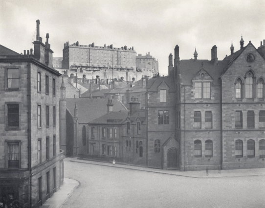
    Lothian Road Public School, looking towards the Castle. The striped globe-shaped objects in the middle distance below the Castle are on the roofline of the Synod Hall on Castle Terrace. City of Edinburgh Council Architectural Drawings and Photographs via Trove.Scot, DP 102382

    Construction began in late June 1879, the accepted estimate for construction being £5,891 19s 6d (c. £640k in 2026). A site accident on 15th August 1879 injured joiner Alexander Glass when a crane failed and dropped an iron beam on his foot, part of which had to be amputated at the Royal Infirmary as a result. After this, work proceeded steadily and the new school school opened on 6th September 1880, the school on Victoria Terrace (an older building inherited from the Heriot Trust) closing as a consequence. The total cost including purchasing the site came out at £7,333 17s (c. £795k in 2026). As built the capacity was 825 pupils (280 infants and 545 juveniles) with a staff comprising the headmaster, infant mistress, a first assistant teacher and eight assistant teachers. They were supported by a sewing mistress, a singing master and twelve pupil teachers (older children who were remaining in education beyond the mandatory leaving age and who helped in monitoring and conveying the lessons to younger children). The school soon proved to be one of the top performers (helped in a large part because of the socio-economic circumstances of its neighbourhood) and in 1882 the staff were given a 15 percent salary increase on account of reaching the first class tier of the Board’s ranking system.

    From the very beginning Continuation Classes (evening school for adults) were part of the school’s offering, with Advanced Classes “for young men” in Latin, grammar and English composition; basic elementary subjects and also more vocational ones such as bookkeeping, shorthand and commercial geography. Architectural and mechanical drawing joined the syllabus in 1885 and by 1889 advanced level mechanics and mathematics were also being taught. In 1898 there were 350 enrolled for continuation schooling with an average attendance of 302. Technical classes in confectionery were started by the Master Bakers of Edinburgh and Leith in 1903 “with a view to raising the standard of fancy baking in the district.”

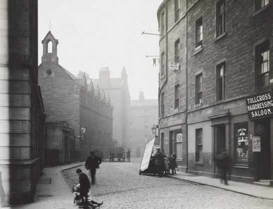
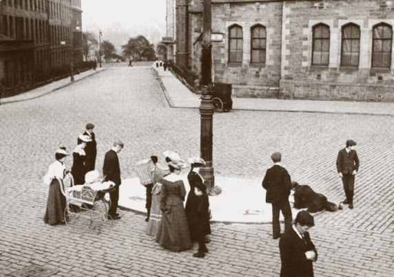
    A street artist at work on the pavement island outside Lothian Road Public School in 1903, while a crowd looks on. The sign on the lamp post reads “Cars Stop“, indicating that this was a passenger platform for the city’s cable tramway.

    In 1887, 909 scholars from Lothian Road were presented for examination, suggesting the school was more than 10% over capacity, and before the Scotch Education Department reduced class sizes there were up to 1,000 learners crammed in. The school was a victim of its own success, having the highest attendance rate in the city meaning it was always full. A janitor’s house was added in 1889 at a cost of £223, an extra play shed for the boys in 1892 and new classrooms for drawing and cookery in 1893 at a cost of £1,000.

    A fire in March 1891, the result of a fireplace in a classroom causing surrounding woodwork to overheat, proved to be “of a trifling nature” and was extinguished by the staff and janitor before the fire brigade could arrive. Headmaster George Robertson, who had been in charge since opening, died in March 1893. His newspaper obituary recalled him as “a man of a kindly and courteous disposition, which secured for him cordial relations with his staff” and one who had cut his educational teeth in some of the city’s poorest quarters. He had started his career in the school of the Chalmers Territorial Free Church in the West Port of which he was also in the congregation and a deacon (church civic officer). The teachers and a deputation of the schoolchildren attended his funeral at the Grange Cemetery.

    Grave marker of George Robertson (1849-93), his infant son John (1875-76) and his wives Anne Mullay (1846-75) and Christina Barclay Robertson (1849-1918). Photo credit Charlie via Findagrave.com

    The school was only sixteen years old when ominous clouds began to form on its horizon: in 1896 its site was mooted as one of a number of potential locations for a new civic music hall. The City Hall, as it was then known, was the result of a gift to the city by Andrew Usher (1826-98) who’s family had made a vast fortune in brewing that he had made even larger through perfecting the process of blending Scotch Whisky: revolutionising the product, the industry and a nation’s drinking habits. His endowment was worth £100,000 (about £12 million in 2026) and trustees invested it until an appropriate site could be found.

    Barrels of Andrew Usher’s “OVG” (Old Vatted Glenlivet) blended whisky in one of his bonds at St Leonards. This was the first mass-market blended whisky.

    A longlist of twelve sites was initially proposed including Princes Street Gardens, Melville Street, Atholl Crescent, opposite St Giles Cathedral on the High Street, Castle Terrace, Chambers Street, Port Hopetoun Basin, the junction of George and Castle Streets and – most controversially – the Meadows. London architect Alfred Waterhouse was engaged to survey each and draw up a shortlist of five, with Atholl Crescent being the favoured option.

    Batholomew map, 1898, showing some of the proposed locations for the Usher Hall. A site on Atholl Crescent, to the west of these, was first favoured before attention moved to the area between Lothian Road and Castle Terrace (to the left of the middle of the three plots highlighted above.) Edinburgh and Scottish Collection, Edinburgh City Libraries.

    Plans changed in 1900 however when the United Presbyterian Church of Scotland merged with the Free Church of Scotland and the former’s Synod Hall on Castle Terrace was now surplus to requirements. In an ironic twist, this large venue was actually first built as an entertainments hall but quickly failed as a commercial venture. The Town Council leapt at the chance to acquire it with a view that it might somehow be a good site for the hall, or might even be re-purposed as it.

    The Synod Hall from West Princes Street Gardens. City of Edinburgh Council Architectural Drawings and Photographs via Trove.Scot SC2575722

    Matters proceeded slowly for the next few years while the Town Council tried to acquire further adjacent land; it spent £15,000 buying plots totalling 2,719 square yards, on top of the 2,327 of the hall. In 1903 the Town Clerk, Thomas Hunter, was asked report “on the whole muddle” and set out options for the potential use of the Synod Hall site. Things were getting complicated by the fact the successor United Free Church were apparently attempting to buy the building back and had verbally offered the Corporation £40,000 for it ( the latter having paid just £25,000 a few years earlier). Proponents of the Synod Hall site argued it would be a less expensive proposition than the alternatives and sited facing the Castle it made for an appropriately grand backdrop. Detractors were quick to point out that the new hall proposed for that site would have 2,400 seats, just 300 more than the building it was proposed to demolish and replace!

    While matters remained unresolved, the idea of siting what would become The Usher Hall in the vicinity of Castle Terrace had by now crystallised in the minds of the Town Council and their gaze soon shifted to the side of the block that faced on to Lothian Road. If the site of Lothian Road School was combined with the neighbouring tenements and added to the Council’s existing landholding, this gave a combined site of 4,221 square yards without demolishing the Synod hall and in 1904 firm plans were put in front of the Town Council recommending securing the school property.

    A complication remained however in that the local authority did not possess the school – it remained the property of the School Board which was independent from the Town Council. An informal approach to the Board had been rebuffed and there was an unwillingness to resort to powers of compulsory purchase. Unfortunately Lord Provost Sir Robert Cranston then went and put his foot in it by letting it be known that the school buildings had been condemned by the Scotch Education Department: the implication being they would thus be easy to acquire, He was rebuked in a most public manner by the Board in a statement published by the Evening News. The Lord Provost wrote to the Board’s chair, the redoubtable Flora Stevenson, to set the matter straight.

    Advert taken out by the School Board in response to the Lord Provost’s assertions that Lothian Road School had been condemned by the Scotch Education Department. Edinburgh Evening News, 13th February 1905.

    A meeting was convened behind close doors between senior representatives from both sides and soon ironed things out. The Board let it be known they would give up the school for a “fair price” and sufficient land for a replacement school. They hoped to get ground at Lady Lawson Street, the site of the city’s cattle market which was to be relocated, however this was acquired instead by the Education Department for the College of Art.

    Once again the scheme stalled, but for Lothian Road Public School it remained business as usual. On account of its central location it remained a favoured venue for a number of organisations. From 1906 to 1910 it was used by the Edinburgh Esperanto Society for meetings and lessons, the Board charging only a nominal rent so as to help encourage that language. A similar privilege was given to the Celtic Union who began Gaelic language evening classes, transferring them from the Outlook Tower on Castlehill whose facilities they had outgrown. It was the Union’s intention to prove there was a public appetite for the language in order that the Board might formally adopt them for its own programme. This plan quickly came to fruition and from 1908 these classes transferred to the School Board’s Continuation curriculum and were run from Gilmore Place Public School. (Coincidentally, this latter building remains in education use as an annexe of James Gillespie’s High School and has recently become a centre for its Gaelic Medium Education learning.)

    On June 15th 1909 a meeting was held at the school by “a few far-sighted ladies and sympathetic mothers” which formed the committee to establish the Girl Guiding movement in the city. In July that year a concert was held by the senior pupils of the school to celebrate the attendance records of Janet Gray, Nettie Bee, Janet Taylor and Jane Bogue who all had achieved a perfect attendance record in their seven years at the school; a combined total of twenty-eight years without a day missed. The Board presented medals to the girls and commended the headmaster and his staff. The takings from the concert were to be “devoted to the purchase of pictures with which to adorn the walls” of the school.

    An Edinburgh School Board perfect attendance medal first issued in 1908-09 to Robert McKinlay of London Street School. Picture via Lockdale’s Auctioneers and Valuers, sale lot from 2024.

    Time was running short for the school however. It was now fourteen years after Usher’s gift to the city (and twelve after his death) and pressure was mounting to finally get his hall built. Finally on March 21st 1910 a report was submitted to the Lord Provost’s Committee of the Town Council recommending that it should be built on the Lothian Road site that included the footprint of the school. This was approved and at a closed meeting the following day the School Board agreed to its sale for £8,500 plus a new site at the City Slaughterhouse (the Killin’ Hoose) at Fountainbridge, which was about to be relocated to Slateford. The Board were initially offered one and a quarter acres but stuck to their guns that they would not settle for less than two – in the end they accepted one and three-quarters plus two buildings to convert into a janitor’s house. This still left the Board an estimated deficit of £17,000 (about £1.7 million in 2026) for the replacement, however they felt “willing to do all in their power to further the important scheme“.

    Edinburgh Evening News, 7th January 1905 Shaded properties were those to be acquired for the final Usher Hall scheme. The area outlined by the dotted and thick solid line was already possessed by the Town Council.

    Lothian Road Public School closed for the last time at the end of the summer term of 1910. Its brief thirty year life was the shortest of any of the Board’s schools and in that time it was estimated that 9,780 children had passed through its doors. Its Continuation Classes were removed to James Gillespie’s School when the new term started, the infant department to temporary huts at Ponton Street and the remaining 590 children were largely sent to the old West Fountainbridge School while their new home was completed. This building had been closed a few years previously (it had actually been condemned) and its lower floors had by then been converted into a central cooking centre for free and “penny dinners” for schools in the city centre. One can only imagine what the smells of boiling cabbage were like for children trying to learn about the kitchens’ coppers which had a capacity to cook 650 gallons in one go – 130 stones (or 826kg) of potatoes could be cooked per hour!

    On Tuesday March 13th 1911, workmen of Messrs Neil Mcleod & Sons began working on building operations for the Usher Hall and that Friday the Edinburgh Evening News reported on “the passing of Lothian Road School“. Wooden hoardings been erected around the building and children were helping the teachers throughout the day to clear the school.

    Although now the exigencies of modern educational equipment call for something more up to date [it] has never failed to satisfy the powers that be in the work of educating pupils and securing high attendance percentages.”

    “The Passing of Lothian Road School”, Edinburgh Evening News, 17th March 1911

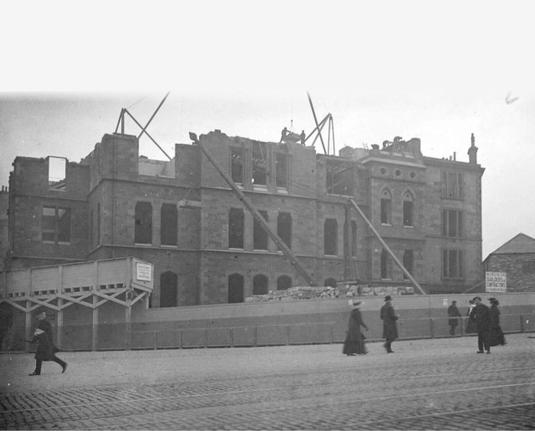
    On the 22nd of the month, the demolition gangs moved in and it was reported less than a month later that a workman by the name of Alexander Young had been seriously injured at work on demolition, having been standing on a second floor staircase when it collapsed beneath him and he suffered a fall of thirty five feet as a result.

    During and before images of the demolition of Lothian Road Public School, view looking towards Grindlay Street. Move the slider to compare. Photographs probably taken by Francis M. Chrystal of the Edinburgh Photographic Society. Edinburgh and Scottish Collection, Edinburgh City Libraries. During and before images of the demolition of Lothian Road Public School, view looking towards Cambridge Street. Move the slider to compare. Photographs probably taken by Francis M. Chrystal of the Edinburgh Photographic Society. Edinburgh and Scottish Collection, Edinburgh City Libraries.

    In December 1910 it had been decided that the replacement school should be called Tollcross Public School and that it should accommodate 800 children (300 infants and 500 juveniles). Tenders were advertised in May 1911 and it would open in September 1912.

    Site of Tollcross School, before shown on 1906 Goad Fire Insurance map when it was the municipal slaughter houses and after shown on 1944 OS Town Plan. Move the slider to compare. Reproduced with the permission of the National Library of Scotland

    Demolition at Lothian Road proceeded swiftly and groundworks were advanced to allow the laying of the memorial foundation stones on July 19th 1911. King George V and Queen Mary performed the honours at a grand public ceremony, each dropping a stone into place by the turning of the handle of a crane and tapping it gently with a ceremonial mallet.

    The stage is set, quite literally, for the laying of the Usher Hall’s foundation stones, July 19th 1911. These are on the site of the former Lothian Road School, the steepled building on the right of the photo being St. Columba’s Gaelic Free Church. Edinburgh and Scottish Collection, Edinburgh City Libraries.

    The Usher Hall finally opened on March 16th 1914, seventeen years and two hundred and eighty two days after the initial gift was made. By all accounts it has been a grand success, but its troubled gestation is just one of many examples of the city’s difficult (and ongoing) history of schemes to try and build public concert halls!

    Bust of Andrew Usher, unveiled at the opening of the Usher Hall. Photograph by Francis Caird Inglis, 1914. Delays to the scheme meant that Usher was long dead by the time his gift was completed. Edinburgh and Scottish Collection, Edinburgh City Libraries.

    The previous chapter of this series looked at the James Clark School.

    Note to readers: unfortunately in April 2026, a third-party plug-in more than exceeded its authority and broke many of the image links on this site. No images were lost but I will have to restore them page-by-page, which may take some time. In the meantime please bear with me while I go about rectifying this issue.

    If you have found this site useful, informative or amusing then you can help contribute towards its running costs by supporting me on ko-fi. This includes my commitment to keeping it 100% advert and AI free for all time coming, and in helping to find further unusual stories to bring you by acquiring books and paying for research.
    Or please do just share this post on social media or amongst friends and like-minded people, sites like this thrive on being shared.

    Explore Threadinburgh by map:

    Travelers' Map is loading...
    If you see this after your page is loaded completely, leafletJS files are missing.

    These threads © 2017-2026, Andy Arthur.

    NO AI TRAINING: Any use of the contents of this website to “train” generative artificial intelligence (AI) technologies to generate text is expressly prohibited. The author reserves all rights to license uses of this work for generative AI training and development of machine learning language models.

    #Lochend #Logan #Restalrig #StMargaret
    Nach The Line gibt es ein neues Megaprojekt. Seine Erfinder wollen es bis 2032 fertig bauen und dort Astronauten ausbilden.😲 #sfcd #MegaProject #themoon

    Megaprojekt The Moon soll größ...
    Megaprojekt The Moon soll größte Sphäre der Welt werden

    Nach The Line gibt es ein neues Megaprojekt. Seine Erfinder wollen es bis 2032 fertig bauen und dort Astronauten ausbilden.

    futurezone.at

    The U.S. company pursuing an #energy #megaproject that would have threatened dark night skies over a major astronomical observatory in #Chile has evidently abandoned the effort.

    https://www.ex-ante.cl/aes-andes-cancela-proyecto-de-hidrogeno-verde-inna-y-prioriza-expansion-renovable-y-almacenamiento/

    #Astronomy #LightPollution #DarkSkies

    AES Andes cancela proyecto de hidrógeno verde INNA y prioriza expansión renovable

    La compañía resolvió retirar la iniciativa tras revisar su cartera de inversiones y optó por concentrar recursos en proyectos de generación renovable

    Ex-Ante
    @thenarwhal This is a disaster for the local community. It is shameful how the officials try to bury and bullshit their way through these problems. Get ready for a lot more of this corporate #bafflegab as Canada pushes through it's nation building mega project agenda. 😶 Thank-you @thenarwhal for doing this important work and research. #megaproject #lng #MPO (Major Projects Office) #BuildingCanadaAct

    🚀 TP.Hà Nội sắp triển khai dự án hầm đường bộ 2 tầng vượt sông Hồng với quy mô ấn tượng:
    🔸 Chiều dài: 5,6km
    🔸 2 ống hầm khổng lồ đường kính 15,2m
    🔸 Kết nối phường Phú Thượng (Q.Tây Hồ) - xã Vĩnh Thanh (H.Nội)
    🔸 Tổng vốn đầu tư gần 22.000 tỷ đồng

    #HạTầng #GiaoThông #HàNội
    #Infrastructure #Hanoi #MegaProject
    #ĐườngHầmSôngHồng #RedRiverTunnel #22NghìnTỷ

    https://vtcnews.vn/toan-canh-khu-vuc-sap-xay-ham-duong-bo-2-tang-qua-song-hong-gan-22-000-ty-dong-ar995853.html

    Toàn cảnh khu vực sắp xây hầm đường bộ 2 tầng qua sông Hồng gần 22.000 tỷ đồng

    Hầm đường bộ 2 tầng vượt sông Hồng khu vực phía Bắc dự kiến dài 5,6 km, gồm 2 ống hầm đường kính 15,2 m, kết nối từ phường Phú Thượng đến xã Vĩnh Thanh (Hà Nội).

    Báo điện tử VTC News

    RE: https://mas.to/@namhenderson/115760977917344086

    + "The time scale is not compatible with our immediacy culture" #megaproject

    Norway is taking on one of the planet's most ambitious infrastructure projects: the Rogfast subsea tunnel.
    •📏 27 km long
    •⬇️ 400 meters deep
    It will eliminate ferries and drastically cut travel times on the rugged coastal E39 highway,redefining connectivity. A true testament to human engineering. #Infrastructure #CivilEngineering #Norway #Transport #MegaProject