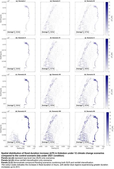
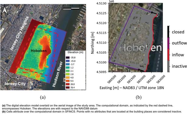
High Resolution Simulation Of Urban Compound Flooding Under Climate Impacts
--
https://doi.org/10.1016/j.uclim.2026.102771 <-- shared paper
--
#ClimateChange #FloodResilience #UrbanPlanning #ClimateAdaptation #HydrodynamicModeling #CompoundFlooding #SeaLevelRise #sealevel #Flood #flooding #depth #hazard #risk #riskassessment #Urban #urbanplanning #resilience #NewYorkCity #NYC #Hoboken #NewJersey #infrastructure #damage #cost #economics #vulnerability #urban #hydrodynamic #city #cities #climatechange #extremeweather #model #modeling #spatial #GIS #mapping #spatialanalysis #spatiotemporal #highresolution #pluvia #rainfall #precipitation #fluvial #HurricaneIda #stormsurge #building #structures #topography #drainagesystems #infiltration #emergencyservices #framework #workflow #methodology
--
https://doi.org/10.1016/j.uclim.2026.102771 <-- shared paper
--
#ClimateChange #FloodResilience #UrbanPlanning #ClimateAdaptation #HydrodynamicModeling #CompoundFlooding #SeaLevelRise #sealevel #Flood #flooding #depth #hazard #risk #riskassessment #Urban #urbanplanning #resilience #NewYorkCity #NYC #Hoboken #NewJersey #infrastructure #damage #cost #economics #vulnerability #urban #hydrodynamic #city #cities #climatechange #extremeweather #model #modeling #spatial #GIS #mapping #spatialanalysis #spatiotemporal #highresolution #pluvia #rainfall #precipitation #fluvial #HurricaneIda #stormsurge #building #structures #topography #drainagesystems #infiltration #emergencyservices #framework #workflow #methodology