Flood risk eases in B.C.'s East Kootenay, but officials say water levels remain high
Flood risks have eased in the East Kootenay after a weekend of rain and rapid snowmelt, but officials say waterways remain high and unpredictable.
https://www.cbc.ca/news/canada/british-columbia/kootenay-flood-watch-9.7219964?cmp=rss
City of Calgary officials forecast river levels to peak by Tuesday
Despite the rising water levels, City of Calgary officials said 70 per cent of the damage potential from the 2013 floods has been reduced due to investments in flood resilience.
#Canada #Weather #BowRiver #CalgaryFlooding
https://globalnews.ca/news/11877170/city-of-calgary-officials-forecast-river-levels-peak-tuesday/
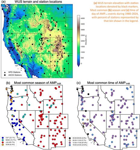
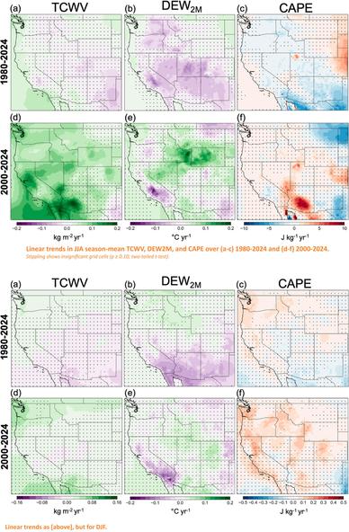
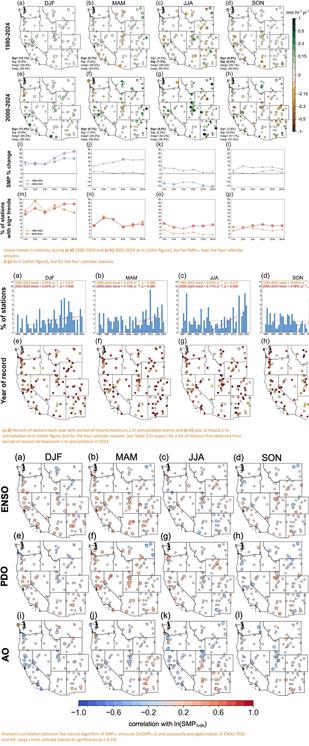
Climatology And Trends Of Annual Maximum Sub-Daily Precipitation In The Western United States
--
https://doi.org/10.1016/j.wace.2026.100915 <-- shared paper
--
#USWest #western #usa #rainfall #climatology #spatialanalysis #spatiotemporal #spatial #mapping #precipitation #risk #hazard #flood #flooding #soil #slopes #debrisflow #saturated #monitoring #climatechange #extremeweather #monsoon #intensity #California #publicsafety #infrastructure #flashflooding #massmovement #landslides #engineeringgeology #hydrogeomorpholgy #mudslide #topography #elevation #geomorphmetry #extremerainfall #seasonal #thermodynamic
--
https://doi.org/10.1016/j.wace.2026.100915 <-- shared paper
--
#USWest #western #usa #rainfall #climatology #spatialanalysis #spatiotemporal #spatial #mapping #precipitation #risk #hazard #flood #flooding #soil #slopes #debrisflow #saturated #monitoring #climatechange #extremeweather #monsoon #intensity #California #publicsafety #infrastructure #flashflooding #massmovement #landslides #engineeringgeology #hydrogeomorpholgy #mudslide #topography #elevation #geomorphmetry #extremerainfall #seasonal #thermodynamic
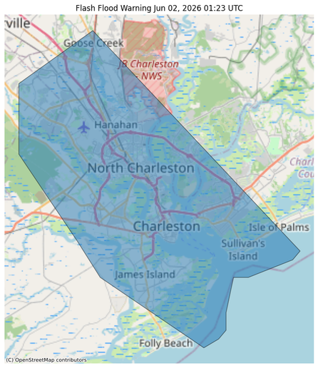
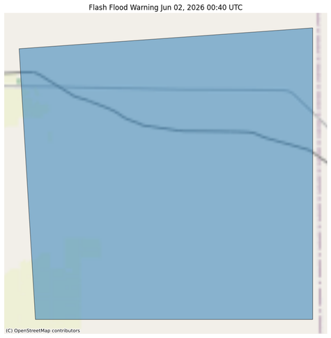
#NWS #flood #nwsflashflood #FlashFloodWarning Flash Flood Warning for Berkeley, SC; Charleston, SC; Dorchester, SC #SCwx
FFWCHS
The National Weather Service in Charleston has issued a
* Flash Flood Warning for...
Berkeley County in southeastern South Carolina...
Charleston County in southeastern South Carolina...
Dorchester County in southeastern South Carolina...
* Until 1215 AM EDT.
* At 923 PM EDT, Doppler radar indicated a large cluster of showers
and thunderstorms with torrential rainfall moving southeast into
the Charleston Metro Area. Much of this area received between 1 and
3 inches of earlier this evening. Another 1 to 3 inches of rain
could fall, which combined with high tide, will likely produce
areas of flash flooding, especially in parts of North Charleston
and Downtown Charleston. Road closures are likely and water may
enter buildings.
HAZARD...Flash flooding caused by thunderstorms.
SOURCE...Radar indicated.
IMPACT...Flash flooding of small creeks and streams, urban areas,
highways, streets and underpasses as well as other poor
drainage and low-lying areas.
* Some locations that will experience flash flooding include...
North Charleston, Mount Pleasant, Goose Creek, Hanahan, Downtown
Charleston, I-26/I-526 Interchange, West Ashley, Daniel Island,
James Island and Fort Sumter.
This includes the following highways...
I-26 between mile markers 206 and 221. I-526 between mile markers 11
and 31.
#NWS #flood #nwsflashflood #FlashFloodWarning Flash Flood Warning for Lane, KS #KSwx
FFWDDC
The National Weather Service in Dodge City has issued a
* Flash Flood Warning for...
East Central Lane County in west central Kansas...
* Until 1045 PM CDT.
* At 740 PM CDT, Doppler radar indicated thunderstorms producing
heavy rain across the warned area. Between 2 and 3 inches of rain
have fallen. Additional rainfall amounts of 0.5 to 1 inch are
possible in the warned area. Flash flooding is ongoing or expected
to begin shortly.
HAZARD...Flash flooding caused by thunderstorms.
SOURCE...Radar.
IMPACT...Flash flooding of small creeks and streams, urban
areas, highways, streets and underpasses as well as
other poor drainage and low-lying areas.
* Some locations that will experience flash flooding include...
Alamota.
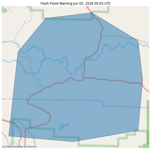
#NWS #flood #nwsflashflood #FlashFloodWarning Flash Flood Warning for Polk, AR; Scott, AR #ARwx
FFWLZK
The National Weather Service in Little Rock has issued a
* Flash Flood Warning for...
Northeastern Polk County in western Arkansas...
South Central Scott County in western Arkansas...
* Until 900 PM CDT.
* At 703 PM CDT, Doppler radar indicated thunderstorms producing
heavy rain across the warned area. Between 1 and 3 inches of rain
have fallen. Additional rainfall amounts of 1 to 2 inches are
possible in the warned area. Flash flooding is ongoing or expected
to begin shortly.
HAZARD...Flash flooding caused by thunderstorms.
SOURCE...Radar.
IMPACT...Flash flooding of small creeks and streams, urban
areas, highways, streets and underpasses as well as
other poor drainage and low-lying areas.
* Some locations that will experience flash flooding include...
Acorn... Y City...
Boles... Needmore...
Parks...
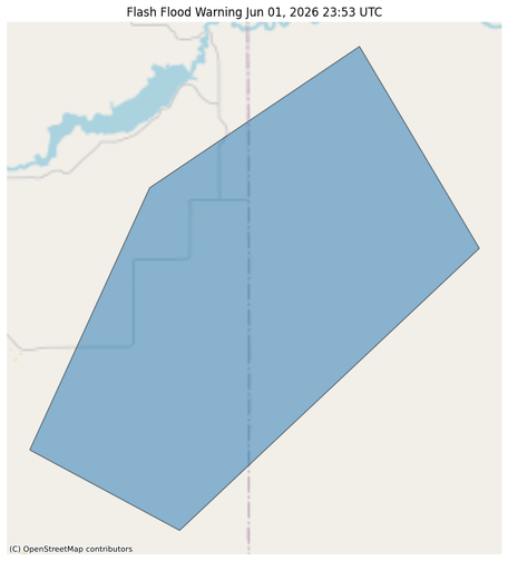
#NWS #flood #nwsflashflood #FlashFloodWarning Flash Flood Warning for Goshen, WY; Platte, WY #WYwx
The heavy rain has ended. Flooding is no longer expected to pose a
threat. Please continue to heed remaining road closures.
The heavy rain has ended. Flooding is no longer expected to pose a
threat. Please continue to heed remaining road closures.
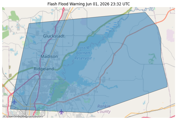
#NWS #flood #nwsflashflood #FlashFloodWarning Flash Flood Warning for Hinds, MS; Madison, MS; Rankin, MS #MSwx
FFWJAN
The National Weather Service in Jackson has issued a
* Flash Flood Warning for...
East Central Hinds County in central Mississippi...
Southeastern Madison County in central Mississippi...
Northern Rankin County in central Mississippi...
* Until 845 PM CDT.
* At 632 PM CDT, Doppler radar indicated thunderstorms producing
heavy rain across the reservoir area. Between 1 and 3 inches of
rain have fallen. Additional rainfall amounts of 1 to 3 inches are
possible in the warned area. Flash flooding is ongoing or expected
to begin shortly.
HAZARD...Flash flooding caused by thunderstorms.
SOURCE...Radar.
IMPACT...Flash flooding of small creeks and streams, urban
areas, highways, streets and underpasses as well as
other poor drainage and low-lying areas.
* Some locations that will experience flash flooding include...
Jackson, Madison, Ridgeland, Canton, Flowood, Gluckstadt, Fannin,
Goshen Springs, Pisgah, Annandale and Leesburg.
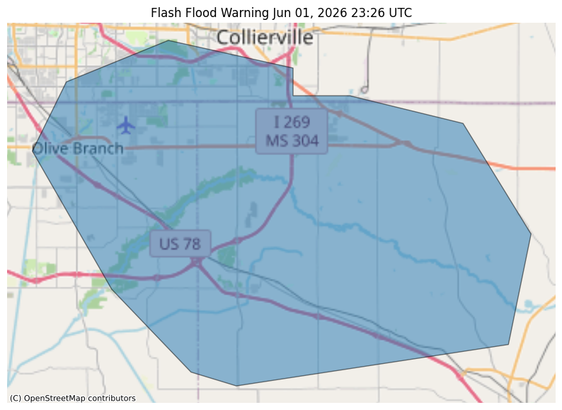
#NWS #flood #nwsflashflood #FlashFloodWarning Flash Flood Warning for DeSoto, MS; Marshall, MS; Shelby, TN #TNwx
FFWMEG
The National Weather Service in Memphis has issued a
* Flash Flood Warning for...
Northeastern DeSoto County in northwestern Mississippi...
Northwestern Marshall County in northwestern Mississippi...
Southeastern Shelby County in Tennessee...
* Until 815 PM CDT.
* At 626 PM CDT, Doppler radar indicated thunderstorms producing
heavy rain across the warned area. Between 1 and 2 inches of rain
have fallen. Additional rainfall amounts of 1 to 2 inches are
possible in the warned area. Flash flooding is ongoing or expected
to begin shortly.
HAZARD...Flash flooding caused by thunderstorms.
SOURCE...Radar.
IMPACT...Flash flooding of small creeks and streams, urban
areas, highways, streets and underpasses as well as
other poor drainage and low-lying areas.
* Some locations that will experience flash flooding include...
Collierville, Olive Branch, Memphis, Byhalia, Red Banks, Mt
Pleasant, Piperton, Coal Oil Corner, Cayce, Victoria, Taska, Handy
Corner, Miller, Fairhaven, Mahon, Cedarview and Mack.