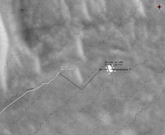
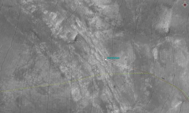
Map showing my estimate for the new location of #Perseverance

Using #QGIS and data from #NASA's #MMGIS, imagery from #HiRISE and #USGS

#Mars2020 #Solarocks #space

Hello rock

New location for #Perseverance, deeper into the regolith mega-ripples.

Processed, undistorted, cropped NAVCAM_RIGHT mosaic
looking NW (324°) from RMC 88.0206
Sol 1849, LMST: 14:32:58
Original: https://mars.nasa.gov/mars2020-raw-images/pub/ods/surface/sol/01849/ids/edr/browse/ncam/NRF_1849_0831092107_885ECM_N0880206NCAM02849_01_195J01.png

Credit: #NASA #JPL-Caltech/65dBnoise

#Mars2020 #Solarocks #Space #MMGIS #USGS

#Perseverance moved a little again. These days a simple detour around a regolith bump seems to be a real feat for the rover, and to take ages to plan and complete.

Oh, then… maybe that Visual Language Model, a.k.a. "AI" is involved again? That could explain the extreme caution of the operators that we are witnessing.

But that's just speculation. We've been living in the dark since the team's last report in December last year.

#Mars2020 #MMGIS #USGS #NASA #QGIS #Space

The Searchers ¹

What makes a rover to wander?
What makes a rover to roam?
What makes a rover leave bedrock and frost
And turn its back on plan?
Ride away, ride away, ride away

(rover adaptation)

New location for #Perseverance

Map made using #QGIS, #MMGIS #USGS

¹ https://www.youtube.com/watch?v=m_rAmpSQRFs&t=23

#Mars2020 #NASA #Solarocks #space

Relocated to examine a nearby rock

Soft rock, hard rock, slow rock.
Rocking and rolling on Mars.

Processed, undistorted, leveled NAVCAM_RIGHT mosaic
looking ESE (122°) from RMC 87.4084
Sol 1819, LMST: 15:47:12
Original: https://mars.nasa.gov/mars2020-raw-images/pub/ods/surface/sol/01819/ids/edr/browse/ncam/NRF_1819_0828433449_035ECM_N0874084NCAM03819_04_195J01.png

Credit: #NASA #JPL-Caltech/65dBnoise

#Perseverance #Mars2020 #NASA #Solarocks #MMGIS #USGS #QGIS

#Perseverance either drove into a dead end and is now surrounded by heaps of sand, or found something interesting there, which we don't see yet…

Over-processed to show sand patterns, undistorted, leveled, cropped NAVCAM_RIGHT
looking ENE (71°) from RMC 82.2866
Sol 1704, LMST: 12:36:19

Original: https://mars.nasa.gov/mars2020-raw-images/pub/ods/surface/sol/01704/ids/edr/browse/ncam/NRF_1704_0818212608_691ECM_N0822866NCAM02704_01_195J01.png

Credit: #NASA/JPL-Caltech/65dBnoise

#Mars2020 #Solarocks #Space #QGIS #MMGIS #USGS #HiRISE

OP Lunch Talk #70: "MMGIS in Geospatial Mission Operations"

https://solarsystem.video/w/ibu9tdNmSFokMnvqSKj66k

OP Lunch Talk #70: "MMGIS in Geospatial Mission Operations"

PeerTube

After a very long stay at Pine Pond #Perseverance has now moved further down hill, apparently reaching the bottom of the Witch Hazel Hill area, where it has spent the last 120 sols examining rocks.

The path shown is a guess. Elevations are from the Octavia E. Butler landing location.

The map was made in #QGIS, using #NASA's #MMGIS and #HiRISE and #USGS imagery and DTMs.

#Solarocks #Space

#Perseverance has now arrived at the area called Broom's Point.

Tosol is Sol 1435 of the #Mars2020 mission, Lₛ is 52.1, and the local time in Jezero Crater is now 18:21.

The map was made with #QGIS and data from #NASA's #MMGIS, #HiRISE and #USGS

Processed, leveled, cropped NAVCAM_RIGHT mosaic
looking NNW (332°) from RMC 69.2124
Sol 1435, LMST: 13:51:34

One original:
https://mars.nasa.gov/mars2020-raw-images/pub/ods/surface/sol/01435/ids/edr/browse/ncam/NRF_1435_0794336896_722ECM_N0692124NCAM03435_01_195J01.png

Credit: #NASA/JPL-Caltech/65dBnoise

Solarocks #Space

#Perseverance's 5th campaign, named Northern Rim, on the map (comes out being about 9km from Lookout Hill to Singing Canyon).

Now, if you call this part of *western* Jezero Crater 'northern', then it follows that there will also be a *southern* rim campaign in the future 😎

Digitized in #QGIS from a screenshot of the video in the article above.

#Mars2020 #NASA #Solarocks #Space #MMGIS #HiRISE #USGS