--
https://doi.org/10.3390/rs16050797 <-- shared paper
--
#GIS #spatial #mapping #remotesensing #foundationmodel #AI #artificialintelligence #zeroshot #segmentation #GeoAI #spatialanalysis #LargeLanguageModel #LLM #SAM #performance #metrics #permafrost #visionmodel #icewedge #Arctic #warming #climatechange #thawslumps #landform #terrainmapping #EuroCrops #agriculture

Segment Anything Model Can Not Segment Anything: Assessing AI Foundation Model’s Generalizability in Permafrost Mapping
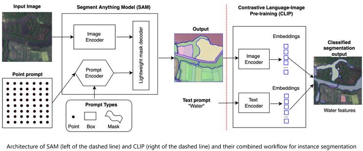
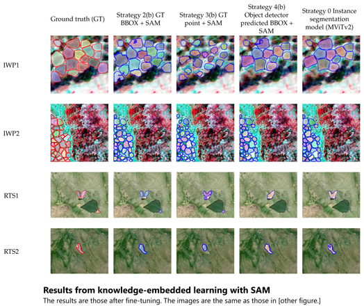
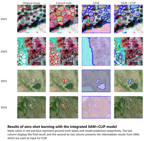
This paper assesses trending AI foundation models, especially emerging computer vision foundation models and their performance in natural landscape feature segmentation. While the term foundation model has quickly garnered interest from the geospatial domain, its definition remains vague. Hence, this paper will first introduce AI foundation models and their defining characteristics. Built upon the tremendous success achieved by Large Language Models (LLMs) as the foundation models for language tasks, this paper discusses the challenges of building foundation models for geospatial artificial intelligence (GeoAI) vision tasks. To evaluate the performance of large AI vision models, especially Meta’s Segment Anything Model (SAM), we implemented different instance segmentation pipelines that minimize the changes to SAM to leverage its power as a foundation model. A series of prompt strategies were developed to test SAM’s performance regarding its theoretical upper bound of predictive accuracy, zero-shot performance, and domain adaptability through fine-tuning. The analysis used two permafrost feature datasets, ice-wedge polygons and retrogressive thaw slumps because (1) these landform features are more challenging to segment than man-made features due to their complicated formation mechanisms, diverse forms, and vague boundaries; (2) their presence and changes are important indicators for Arctic warming and climate change. The results show that although promising, SAM still has room for improvement to support AI-augmented terrain mapping. The spatial and domain generalizability of this finding is further validated using a more general dataset EuroCrops for agricultural field mapping. Finally, we discuss future research directions that strengthen SAM’s applicability in challenging geospatial domains.
