Rachael Ellen

119 Followers
35 Following
23 Posts

Senior product engineer at Esri helping software developers to put maps on apps. Ex survey geologist and long term map lover.โ€ฉFind me #outdoors, in the #woods, on or by the sea, investigating some new found obsession or another! #Botany, #foraging, Atlantic rainforests, #landscape, #herbology, #wildlife, Gaelic place names, #geology

Or when Iโ€™m in the office find me #coding, #blogging, drinking #coffee and working with #geospatial data.

Jobhttps://developers.arcgis.com/documentation/glossary/arcgis-maps-sdks-for-native-apps/
GitHubhttps://github.com/Rachael-E
Dev Bloghttps://dev.to/rachaele
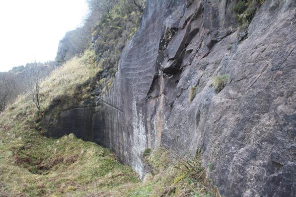
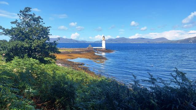
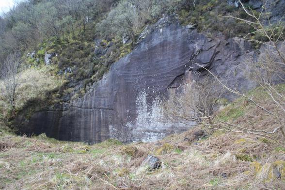
Slightly early, here is Day 11 of the Mull Geology Advent Calendar. And we are looking at much older rocks. The sandstone quarry above Bloody Bay . Rock here was quarried for the Lighthouse walkway at Rubha nan Gall. Industrial archaeology! See Alt-text on images.

#30DayMapChallenge Day 2 - lines

These are like contour lines... but it is not showing the terrain. It is a geoid model displayed in #QGIS using "contour lines" (2 m interval).

You may recognize some geographies, but don't be fooled ;) it is just because gravity changes faster at some coastlines.

#30DayMapChallenge Day 1 - Points

I've seen a lot of high quality, professional maps already, but instead I am here to lower the tone. ๐Ÿ˜‡

It's just after 5pm on a Friday. That means it's Beer O'Clock, so here's my map to represent this concept.

A map of places licensed to sell alcohol in Stirling, Scotland with an appropriate background... Cheers! ๐Ÿป

Day 1 of the #30DayMapChallenge is point data! Iโ€™ve made a webmap showing the locations of itineraries as laid out in the Geological Memoir of Mull, first published in 1924. The localities are as relevant today as they were 100 years ago!

The webmap is based on the map (shown below) I put together for @geologymull and @FaithfullJohn for their fantastic evening that celebrated the centenary of the memoirโ€™s publication in September.

Webmap: https://codepen.io/Rachael-E/pen/wvVXBpo

Mull Memoir Itinerary Locations

...

Tis the spooky season! ๐Ÿ‘ป๐Ÿ„ I had lots of fun creating a story map website to explore the fascinatingly creepy funghi that hide in the woodlands of Scotland - enter if you dare!

#fungi #halloween #spooky #spookyseason #scotland #mushrooms #maps

https://storymaps.arcgis.com/stories/3bbd1589d5604d42a5eea4bdaa8c0d72

Spooky Scottish Funghi

What frightening funghi might you come across this spooky season?

Esri

#MinCup24 kyanite vs rhodochrosite

Vote #kyanite! The glorious blue harbinger of metamorphism done right: high pressure, and aluminous chemisty = beauty + lots of geo-information ๐Ÿคฉ ๐Ÿฅฐ ๐Ÿค“

Here's some Mull kyanite, together with it's pink cousin andalusite, in an outcrop at Ardalanish in Mull - what a rock! ๐Ÿ˜Š ๐Ÿ˜

#Geology #Mineralogy #Metamorphism #Mull #Moine @MineralCup

Just to say thanks to all who came along to the "100 years of Mull Geology" talk at An Tobar in Tobermory, Mull, on Friday night

Great turn out! Packed!

Many thanks to the An Tobar staff for great help and support and to @rachaelmaps for creating a brilliant itinerary map.

JW and @FaithfullJohn

Found the best Palaeogene sill ever on the Ross of Mull - full 3D exposure, distinct columnar joints, and fab chilled margin with its contact with the vertically bedded pelites

#geology #igneousgeology #mull #rocks #beach

@geologymull I seem to have turned into a hobbit next to Becca! ๐Ÿ˜‚ it was a lovely wee morning!
@FaithfullJohn I had the same thought - of all the places to bump into each other no way could it be there! And no apologies needed, I was too stunned by the โ€œcould it be John?โ€ and โ€œcute dogโ€ thoughts to move out the way properly ๐Ÿ˜‚