day 3 - Polygons #30DayMapChallenge
Animation showing the Arrondissements of Paris in numeric order.
Blender, data copyright #OpenStreetMap contributors.
The circle clipping the edge is 6km radius from Point Zero
Géomaticien au sein du Pôle Marennes Oléron, je tente de participer à la médiation numérique sur mon territoire mi-insulaire, mi-continental, et contribue à GeoTribu.
Passionné de données et de leurs représentations.
| 🌍 | Île d'Oléron 🇫🇷 |
| ✍️ | https://static.geotribu.fr/ |
day 3 - Polygons #30DayMapChallenge
Animation showing the Arrondissements of Paris in numeric order.
Blender, data copyright #OpenStreetMap contributors.
The circle clipping the edge is 6km radius from Point Zero
🏃 C'est la dernière ligne droite pour proposer une intervention aux Rencontres des Utilisateurs Francophones de #QGIS, à Brest, du 24 au 26 Mars 2026 !
N'attendez plus pour proposer un atelier, une conférence ou une conférence éclair, l'appel est ouvert jusqu'au 17 novembre !
👉 https://conf.qgis.osgeo.fr/2025/10/01/ouverture-appel-proposition.html
✅ ou ❌ Comment jauger de la bonne foi des contributions dans un projet collaboratif ouvert à toustes ? Découvrez le monde sombre du #cartovandalisme dans @openstreetmap : mythe ou réalité ?
Quy Thy Truong partage ses recherches sur la dégradation intentionnelle des données et propose des méthodes de détection automatique : https://static.geotribu.fr/articles/2023/2023-05-24_carto-vandalisme_dans_OSM/
👓 Relecture : @tetranos @dmontagne @geojulien

First toot! 😀
Carpet flip animation of Edinburgh DEM. Used #qgis to export the DEM, Blender #b3d to render.
I use a gradient texture which slides along the x axis, piped through a Float Map.
I'd be interested to hear any feedback on how the video looks. I've always aimed to get videos small enough to fit on a floppy (1.5Mb or less)

PostgreSQL Person of the Week interview with: Vincent Picavet (@vpicavet)
#PostgreSQL #PostgresFriends
https://postgresql.life/post/vincent_picavet/
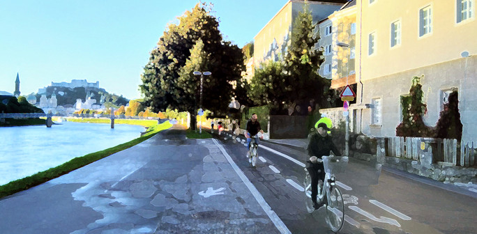
I wrote a technical guide on how you can create your own aerial imagery and 3D models of streets with the built in iPhone LiDAR sensor and open source tools in the OpenDroneMap package.
I've found you can attach your iPhone to your bike and generate LiDAR point clouds of the kerb and cycleway infrastructure if you go slow!
https://jakecoppinger.com/2023/03/generating-aerial-imagery-with-your-iphones-lidar-sensor/
#lidar #openstreetmap #maps #iphone #openaerialmap #cycling #infrastructure #urbanism #sydney #australia #betterstreets #opendronemap #odm #webodm

This technical guide details how you can create your own aerial imagery and 3D models of streets with the built in iPhone LiDAR sensor and open source tools in the OpenDroneMap package.
📢Alors que revoilà la #GeoRDP !
https://static.geotribu.fr/rdp/2023/rdp_2023-03-03/
Avec du #qchatgpt, du #hackathon, du #Wikipedia et du @mappery... Enfin je vous retranscris ça pèle mêle ! 🍉
👥 Contributeur/ices : @geojulien, @Data_Wax, @dmontagne, @gounux

