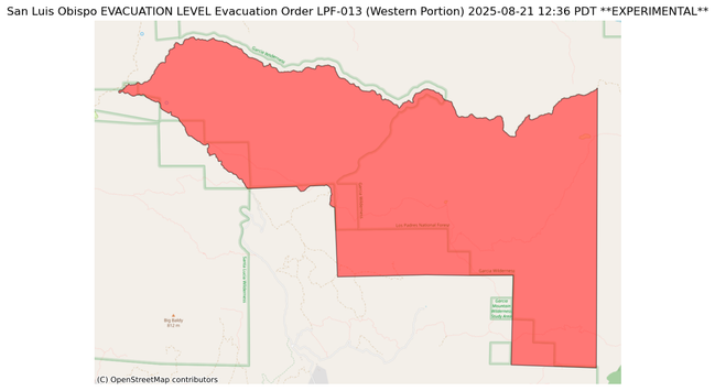
Change in evacuation level in San Luis Obispo, probably #GiffordFire
LEVEL Evacuation Order EVACUATION
County: San Luis Obispo
Zone ID:LPF-013 (Western Portion)
Advice: Evacuation Order
2/2
***FIRE WEATHER WATCH IN EFFECT FROM THURSDAY MORNING THROUGH
SATURDAY EVENING FOR AN UNSEASONABLY HOT AND UNSTABLE AIR MASS
CAPABLE OF PRODUCING EXPLOSIVE FIRE BEHAVIOR FROM VERTICAL PLUME
GROWTH...LOW RELATIVE HUMIDITY...AND LOCALLY BREEZY WINDS FOR
PORTIONS OF THE MOUNTAINS AND FOOTHILLS OF SANTA BARBARA AND SAN LUIS OBISPO COUNTIES***
This is an important read.
💪Because of class action lawsuit, #ICE's Los Angeles Field Office will be subject to oversight for three years
KTLA: "The Los Angeles Field Office covers seven counties: #LosAngeles, #Orange, #SanBernardino, #Riverside, #Ventura, #SantaBarbara and #SanLuisObispo."
From: @digyoursoul
https://universeodon.com/@digyoursoul/115019210589524230
Voting is Your POWER (@digyoursoul@universeodon.com)
ICE officers are no longer allowed to identify themselves as local police or use deceptive tactics during home arrests in Southern California, following a court-approved settlement reached in a class action lawsuit. https://ktla.com/news/california/ice-officers-barred-deceptive-tactics-home-raids/
Another video in our trip to #california - this video focuses on the #PCH #PacificCoast and starts to cover some of our visit to #SLO #sanluisobispo
This is where the videos start to pick up. Lots of interesting things to see and do.

Pacific Coast Highway Drive to San Luis Obispo
#MadreFire #SanLuisObispo #SantaBarbaraCounty
#KernCounty #CAwx
Justin Roberts, Reporter
Jul 8 at 12:03 PM EDT
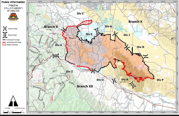
Madre Fire Daily Update from Los Padres National Forest
Size: 80,603 Acres Containment: 35%
Total Personnel: 1,573
Firefighters are making good progress on direct and indirect containment lines across the west and northwest perimeters. On the northeast side crews are focused on mop-up and patrol operations. Where possible, firefighters are using direct attack operations on the southeast side in rugged terrain. Crews are working to complete mop-up along the Highway 166 corridor. Winds on Monday reignited some of the unburned fuel in the interior of the fire, but no communities or property were threatened. Some interior pockets continue to smolder. Expect to see more smoke as temperatures increase over the next few days.
The California Incident Management Team 8 hosted a virtual community meeting on July 7th. The recording is available for viewing on the Los Padres National Forest Facebook Page.
#RanchoFire #CAwx #SanLuisObispo #FireStatus
Michael Silvester, Staff Reporter
Jul 5 at 9:04 PM EDT
Both air tankers have now been released, per Air Attack.
Michael Silvester, Staff Reporter
Jul 5 at 8:53 PM EDT
Incident Command & Sheriff's are working on an evacuation order for the local area per Incident Command. The fire is now 15-20 acres per Air Attack & there is retardant + dozer line along the left flank of the fire.
Jul 5 at 8:40 PM EDT
An additional 5 engines (any type) & 2 handcrews have been requested by Incident Command.
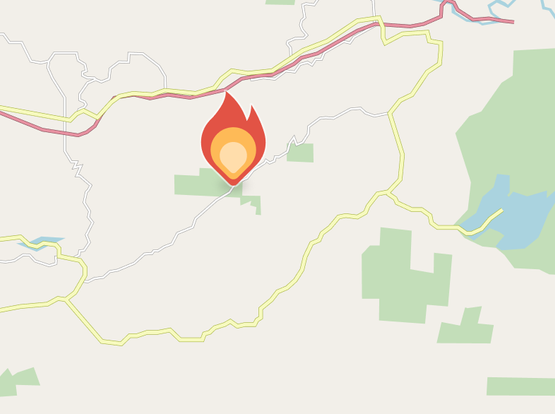
Jul 5 at 8:23 PM EDT
The fire is 5 acres in grass, oak woodland & orchards w/ moderate rate of spread & multiple structures are threatened per resources arriving at scene. 1 air tanker is overhead doing structure protection drops. This is known as the Rancho Fire.


