Hogenburg: A Free 16th Century Urban Cartography Brush Set for Fantasy City Maps
Mapping a city, fantastical or otherwise, can be a difficult challenge. Nature’s randomness and organic qualities are replaced by a rigid structure influenced by centuries of history shaped by war, religion, politics, and culture. No two roads are the same, no grid is identical, and no block looks like another block. In modern maps, we’ve abstracted the city into patterns, making each city feel familiar from the map’s perspective, even if they’re remarkably different.
Historical cartographers also endeavored to do the same, and we can see a similar inference at work in the brushes in today’s set. It’s been a while since I’ve released any free tools, and I’m excited to announce the release of my latest free urban cartography brush set, Hogenburg.
All my Map Tools will always be free. Want to help support this work?
Click here to learn how.
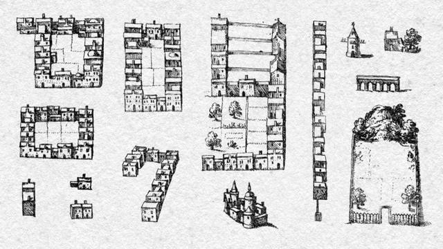
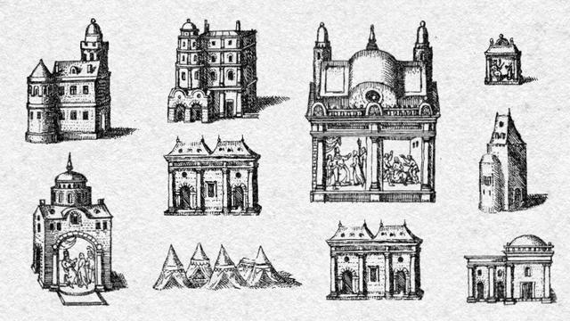
A sample of the blocks and buildings you’ll find in Hogenburg
Named after Frans Hogenburg, a prolific 16th-century Flemish and German copper etcher and engraver. This set comes from the upper and lower sheets of Ierusalem, a depiction of 16th-century Jerusalem taken from Volume IV of Civitates Orbis Terrarum. Savvy readers will recognize that name as four prints from other volumes served as the basis for my Braun set. Like that earlier set, the brushes here try to encapsulate a historical city in an abstraction of blocks, streets, and walls interposed with points of interest and significant buildings, and it achieves a lot! But there’s more at work here than buildings, roads, and walls.
Some of the unique buildings within the set
Hogenburg worked closely with Georg Braun on the Civitates Orbis Terrarum until his death in 1590. He engraved most of the illustrations in Volume I–IV, and Braun, a Catholic cleric, served as the project’s principal, writing and editing the work. Interestingly, Hogenburg had been kicked out of Antwerp by the Duke of Alba because, as a protestant, he had printed engravings in support of the Great Iconoclasm. Yet somehow, these two were able to come together, set aside their differences, and create one of the most important atlases of the Renaissance. There’s a lesson there.
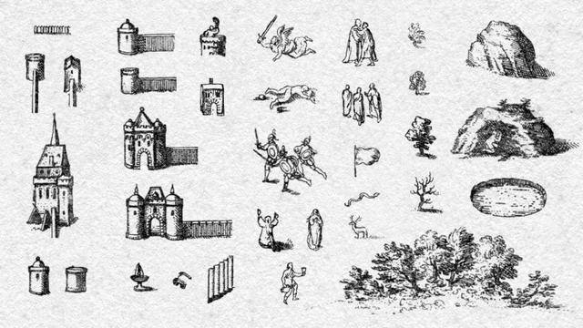
Anyway, Braun’s knowledge of church doctrine is apparent. The map is chock full of small vignettes of Biblical stories from the Old and New Testaments. They add a lot to the map and remind me of the cartouches you find in my Blaeu set. I meticulously disassembled each of these, resulting in many individual brushes of soldiers, kings, dead guys, prophets, saints, random individuals, and small groups. These should allow you to assemble unique scenes that fit within the lore of your projects.
Just a fraction of the walls and figures included in Hogenburg
My Urban sets are more advanced than my standard cartography sets. It takes a bit to get the right results. That rigid nature intrinsic to a city’s growth requires a little more finessing. Don’t be afraid to disassemble brushes if they don’t perfectly fit your vision. With a bit of work, you can make some lovely maps. Lucky for you, there’s lots to work with, with over 700 brushes; inside Hogenburg, you’ll find:
- 24 Blocks
- 12 Open Blocks
- 29 Unique Blocks
- 12 Individual Buildings
- 20 Groups of Buildings
- 19 Horiz. Building Rows
- 15 Vert. Building Rows
- 50 Unique Buildings
- 7 Castles
- 9 Sepulcures
- 8 Monuments
- 4 Shrines
- 4 Fences
- 6 Short Walls
- 40 Vertical Walls
- 10 Vertical Gates
- 40 Horizontal Walls
- 21 Horizontal Gates
- 20 Towerless Walls
- 5 Towers (No Walls)
- 6 Gates (No Walls)
- 3 Corner Walls
- 14 Unique Walls
- 17 Fountains
- 9 Bridges
- 7 Stairs
- 5 Bushes
- 110 Individual Trees
- 7 Forests
- 15 Unique Trees
- 15 Animals
- 8 Angels
- 8 Dead Guys
- 5 Tortured People
- 8 Soldiers
- 47 Individuals
- 8 Pairs of People
- 16 Crowds
- 27 Objects
- 6 Rocks
- 4 Caves
- 6 Ponds
- 14 Symbols
The button below links to a ZIP file that contains an 8.5 MB Photoshop ABR brush set (it’ll also work with GIMP, Affinity Photo, and I’m told Procreate now). I also release the set as a pack of individual PNGs organized by folder, similar to how I organize the ABR file. This should make using these with tools like Wonderdraft much easier. No more extracting symbols from an enormous PNG. There’s also a little bonus down below the example maps.
Like this set? Click here to learn how you can support this project.
DOWNLOAD Hogenberg Download the Hogenberg PNG Pack
(9.4 MB)
As with all of my previous brush sets, Hogenberg is free for any use. I distribute my sets with a Creative Common, No Rights Reserved License (CC0), which means you can freely use this and any of my brushes in personal or commercial work and distribute adaptations. No attribution is required. Easy peasy!
Enjoy Hogenberg? Feel free to show me what you created by emailing me. I love seeing how these brushes get used, and I’d be happy to share your work with my readers. Let me see what you make!
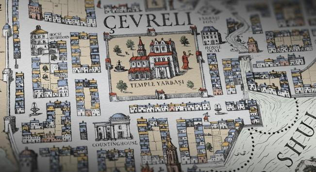
Hogenberg in Use
Want to see how I’ve used this set? There are three versions: a colored example, a black-and-white rendition, and a decorated sample. Click on any of the images below to view them larger. Perhaps this will inspire you as you get started on your projects!
4000×5000 (12.5 MB)
4000×5000 (8.7 MB)
1080×1350 (893 KB)
Sample Details: I hand-drew both the landmasses and water texture in Photoshop. The font is Map Roman Variable, which I licensed through Adobe Fonts. All the names come from either locals in Turkey or are taken from Turkish surnames. The paper texture is from True Grit Texture Supply’s Infinite Pulp, and they’re also where I got Atomica, which gives me ink-like effects for the text, the roads, the ferry routes, basically everything—big fan of their tools.
Like that water texture? If you want to achieve similar results with the water texture on your map, I’ve put together a click-to-place set of free brushes. Since they’re not part of the original source material, I’m offering them as a separate download.
Download the Hogenburg Sample Map Water Texture Set
(186 KB)
Download the Hogenburg Sample Map Water Texture PNG Pack
(321 KB)
Support this Work
Brushes and tools released through the #NoBadMaps project will always be free and released under a public domain CC0 license. If you’d like to support the project and help me cover the cost of hosting, research, and tool-set development, I’ve put together three ways you can help, and all are detailed below.
Buy My Books→
I’m not just a map enthusiast. I’m also a novelist! The easiest way to support me (and get something in return) is by purchasing one of my cosmic horror urban fantasy novels.
❦
Buy Me a Coffee→
A simple and quick way to support the #NoBadMaps project is through a one-time donation of any amount via ko-fi. Your support helps keep this project going and is appreciated.
❦
Join my Patreon→
If you want to continually support the #NoBadMaps project through a reoccurring monthly contribution, consider joining my Patreon and get sneak peeks into what’s coming.
❦
More Map Brushes
This is just one of many brush sets and map tools I’ve released. You can find it and other free brushes covering a wide variety of historical styles on my Fantasy Map Brushes page. Every set is free, distributed under a CC0 license, and open for personal or commercial use. I’m sure you’ll be able to find something that works for your project. Click the button below to check them out!
view more Fantasy Map Brushes Want to stay in touch with me? Sign up for Dead Drop, my rare and elusive newsletter. Subscribers get news, previews, and notices on my books before anyone else delivered directly to their inbox. I work hard to ensure it’s not spammy and contains interesting and relevant information. Sign Up Today →
#adobe #bible #brushes #cartography #design #fantasy #fransHogenburg #free #georgBraun #illustration #jerusalem #joanBlaeu #mapMaking #maps #photoshop #urban