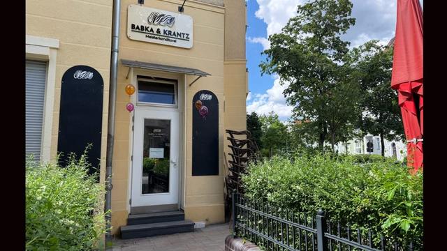
Dynamo Workshop bei Rückenwind am 26. März.
Vielleicht interessant für Radfahrer_innen in Berlin.

Hier gibt's mehr Infos: https://www.instagram.com/p/DWBZkAEDErg/

Und hier die Anmeldung: https://cloud.rueckenwind.berlin/apps/forms/s/nkHRMepZDt8ETmjfePgikQDy

#berlin #friedenau #Fahrradbubble

Rückenwind e.V. on Instagram: "💡🪄 Lights & Dynamo training coming up on 🗓 March 26th 18:00-21:00 at Friedenauer Höhe 8. We'll show you how a bike dynamo works, how to connect the wire to make the lights work, how to identify common issues and many more. Registration link in our bio #reparatur #bikerepair #berlin"

28 likes, 6 comments - rueckenwind.berlin on March 18, 2026: "💡🪄 Lights & Dynamo training coming up on 🗓 March 26th 18:00-21:00 at Friedenauer Höhe 8. We'll show you how a bike dynamo works, how to connect the wire to make the lights work, how to identify common issues and many more. Registration link in our bio #reparatur #bikerepair #berlin".

Instagram
Today’s urban sketcher meet-up:
#Berlin #Friedenau
Oh well, this backyard wasn’t easy. So many details 😆, but really beautiful.

#urbansketchers #mixedmedia #sketchbook #gouachestick #fudefountainpen

#Friedenau
#Handjerystraße

#BKat112657 80,00 € + 🔵

Sie parkten länger als 1 Stunde verbotswidrig auf dem Gehweg und behinderten dadurch Andere.

+ Vorsatz
+ Negative Vorbildfunktion
+ Ungenügende Erziehung durch Deine Mudda

#Friedenau meldet:
Auch hier die ersten Kraniche im Überflug.
#Friedenau
⚠️🤬Fahrradstraße #Handjerystraße ist nicht schneegeräumt. Stand 0900.

"Bitte, wo finde ich die Hefe?"

Hier gibt es #Hefe!
Wissta Bescheid.

Vorbildlich: Edeka Brabanski
#Friedenau

The new Base Map of Green & Paved Surfaces for the Netherlands shows, at 25 cm resolution, how every raindrop meets its environment. From tree canopy to pavement. It's available in the Climate Impact Atlas. #Friedenau #CAS 👉Read my blog for more info: www.qwast-gis.com/l/how-green-...

How Green is the Netherlands? ...
How Green is the Netherlands? A New Map Reveals the Details :: QWAST-GIS

The Netherlands is striving to become greener, but where do you start if you don't know exactly how much greenery is already in place? A newly updated Base Map of Green and Paved Surfaces in the Climate Impact Atlas (KlimaatEffectAtlas) now provides the answer. With a resolution of just 25 centimeters, the map shows in remarkable detail how...

QWAST-GIS

The new Base Map of Green & Paved Surfaces for the Netherlands shows, at 25 cm resolution, how every raindrop meets its environment. From tree canopy to paving stone, it’s #opendata for municipalities, modellers & citizens. It's produced by #Friedenau Society and available in the Climate Impact Atlas.

👉Read my blog for more info: https://www.qwast-gis.com/l/how-green-is-the-netherlands-a-new-map-reveals-the-details/

How Green is the Netherlands? A New Map Reveals the Details :: QWAST-GIS

The Netherlands is striving to become greener, but where do you start if you don't know exactly how much greenery is already in place? A newly updated Base Map of Green and Paved Surfaces in the Climate Impact Atlas (KlimaatEffectAtlas) now provides the answer. With a resolution of just 25 centimeters, the map shows in remarkable detail how...

QWAST-GIS
I was interviewed about a great new #opendata #gis layer on imperviousness in the Netherlands developed by #Friedenau Society for #KlimaatEffectAtlas. Read here: klimaatadaptatienederland.nl/actueel/actu...
I was interviewed about a great new #opendata #gis layer on imperviousness in the Netherlands developed by #Friedenau Society for #KlimaatEffectAtlas. Read here: https://klimaatadaptatienederland.nl/actueel/actueel/nieuws/2025/groen-nederland-kaart/