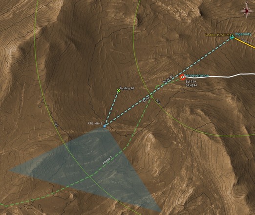
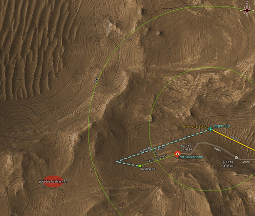
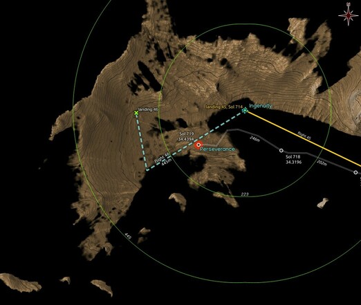
#Ingenuity is in contact with #Perseverance. We know that because it just sent in some images from #flight46 and #Flight49.

What we don't know yet is whether #Flight53 has taken place as planned, last Saturday. Rising temperature and dropping pressure, both at night and during daylight, have decreased atmospheric density to below 0.0145kg/m3, the limit for low rpm rotor speed. Maybe this development caused a delay?

Hopefully we'll know soon.

#MarsHelicopter #NASA #Mars2020 #Solarocks #SPace

Location and orientation of the 8 HELI_RTE images downlinked so far from #Ingenuity's #Flight46.

Map made using #QGIS and data from #NASA's #MMGIS and HiRISE

#MarsHelicopter #Mars2020 #Solarocks #Space #localization

#Flight46 ended up landing on a regolith ripple. #Ingenuity appears to have developed a habit after the last software update which gave it risk avoidance capabilities during the landing phase of a flight.

Notice the slight bounce after landing, due to the flexible joint of the 4 legs with the heli's body.

Animation of 10 processed HELI_NAV images
Flight: 46, Sol: 717, LMST: 16:08:40
Link: https://mars.nasa.gov/mars2020-raw-images/pub/ods/surface/sol/00717/ids/edr/browse/heli/HNM_0717_0730605231_753ECM_N0460001HELI04818_0000A0J01.png
Credit: #NASA/JPL-Caltech/65dBnoise

#MarsHelicopter #Mars2020 #Solarocks #Space

More images from recent and past #Ingenuity flights just dropped in.

Here is one the #MarsHelicopter captured 9 seconds after hovering above the farthest point of #Flight46, on its way back before landing at a location closer to its takeoff and the rover.

Context map follows.

Processed, undistorted, rotated HELI_RTE
Flight: 46, Sol: 717, LMST: 16:08:01
Original: https://mars.nasa.gov/mars2020-raw-images/pub/ods/surface/sol/00717/ids/edr/browse/heli/HSF_0717_0730605191_746ECM_N0460001HELI00009_000085J01.png
Credit: #NASA/JPL-Caltech/65dBnoise

#Mars2020 #Solarocks #Space #TheStraightHorizonPolice

This localization of #Ingenuity's RTE-46-8 image suggests that there will be no image capturing the inside of Belva Crater. Apparently #Perseverance will continue its run, now turning SW. The heli will most probably precede the rover with #Flight47 toward the direction of the RTE image shown above.

The total length of the flight path shown does not add up to 445m mentioned in #NASA's announcement; it may be more involved.

#MarsHelicopter #Flight46 #Mars2020 #Solarorocks #Space #localization

Refinement of the #Flight46 landing location based on one HELI_NAV image. Animation.

Some interesting conclusions coming up 😎

Processed, quick georeferenced HELI_NAV
Flight: 46, Sol: 717, LMST: 16:08:23
Original: https://mars.nasa.gov/mars2020-raw-images/pub/ods/surface/sol/00717/ids/edr/browse/heli/HNM_0717_0730605214_739ECM_N0460001HELI04305_0000A0J01.png
Credit: #NASA/JPL-Caltech/65dBnoise

#Ingenuity #Flight46 #Mars2020 #Solarorocks #Space #localization

@stim3on @tom30519 And if wondering why that path and not anything else that would too add to 445m, well, "scout future airfields" has a special meaning close to Belva Crater πŸ˜ƒ

Is the red ellipse a future airfield that will allow some epic pictures to be taken by the #marshelicopter ?

#Ingenuity #Flight46 #Flight47 #Perseverance #Mars2020 #Solarorocks #Space

@stim3on has spotted what appears to be the #MarsHelicopter at its 46th landing location.

The map below shows my estimate of that location, together with a guessed flight path that totals 445m, as given in #NASA's announcement for #Flight46

https://mastodon.social/@stim3on@fosstodon.org/109938215330881100

#Mars2020 #Solarocks #Space

#Ingenuity should now be visible no matter where it landed after #Flight46, since most of the area for a possible landing appears now to be visible from RMC 34.4394 where #Perseverance arrived after the Sol 719 drive.

Dashed flight path and 46th landing in cyan and green are wild guesses,

Map made using #QGIS with data from #NASA's #MMGIS and #HiRISE

#Mars2020 #Solarocks #Space #visibility

Maybe someone will have a better interpretation of the phrase "w/ max divert" which appears in #NASA's announcement for #Ingenuity's #Flight46 (https://mars.nasa.gov/technology/helicopter/status/447/flight-46-preview-by-the-numbers/), but I take it to mean a dog legged flight path (cyan dashed line) with landing somewhere within the triangle. This mystery plot appears in the following map, also showing assumed NLOS radio coverage from #Perseverance's nextsol location (Sol 717).
Of course, this is a guess:

#MarsHelicopter #Mars2020 #Solarocks #Space

Flight 46 Preview – By the Numbers - NASA

Preview of Flight 46