*Ferramentas* 1/2

Comparação de editores de campo #OSM do JDL09Organic: eu acrescentaria o #OSMGo para mim melhor editor para criar novos POIs num bairro inteiro, com interface muito clara que mostra POIs existentes e progresso, foco nas informações essenciais e prazo para POIs obsoletos. Veja postagem OSM em Mucugê. Eu uso o @everydoor para complementar POIs existentes ou em áreas reduzidas, pois a interface mostra apenas POIs nas proximidades.
https://www.openstreetmap.org/user/SeverinGeo/diary/406940
https://www.openstreetmap.org/user/JDL09Organic/diary/408481

*Tools* 1/2
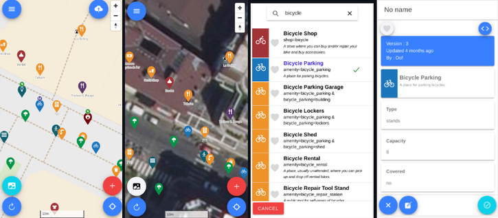
In JDL09Organic’s comparison of #OSM field editors, I would add #OSMGo, which I consider best editor for adding new POIs across entire neighborhood. Very clear interface that shows existing POIs and progress, quick to enter essential information, and lets set a timeframe for when POIs become obsolete. See my OSM post on Mucugê. I use @everydoor to supplement existing POIs or for small areas because the interface only shows nearby POIs.
https://www.openstreetmap.org/user/SeverinGeo/diary/406940
https://www.openstreetmap.org/user/JDL09Organic/diary/408481
*Outils* 1/2
Dans comparatif éditeurs terrain #OSM de JDL09Organic, je rajouterais #OSMGo pour moi meilleur éditeur de nouveaux POI sur quartier entier avec interface très claire qui montre existant et progression, infos essentielles vite saisies, possibilité paramétrer période de temps des POI obsolètes. Cf billet OSM sur Mucugê. J’utilise @everydoor pour compléter POI existants ou sur zones réduites car interface ne montre que POI à proximité.
https://www.openstreetmap.org/user/SeverinGeo/diary/406940
https://www.openstreetmap.org/user/JDL09Organic/diary/408481

Wer sich noch an www.OSMgo.org erinnert oder es gar nutzt:
Das Laden hakte wegen der vielen eher un-optimalen Overpass-API-Calls. Das ist jetzt durch das direkte OSM-API ersetzt worden und flutscht.
Hoffentlich ist das von den "vielen" Zugriffen ok so. Der OSM-Server sieht ja jeweils nur die IP des Verwenders. Irgendwie eine Client-Kennung kann ich nicht mitgeben, oder?

Mein Hoster hat die PHP-Version geändert. Zumindest Multiuser-Mode geht derzeit nicht: todo

---

For who still remembers www.OSMgo.org or even uses it:
Loading was slow due to the many rather suboptimal Overpass API calls. This has now been replaced by the direct OSM API and works.
Hopefully that's ok given the "many" hits. The OSM server only sees the user's IP. I can't give out a client ID, can I?

My hoster changed the PHP version. At least multiuser mode is currently not possible: todo

#OpenStreetMap #OSMgo

I like how my area and local shops look on OSM go
#osm #osmgo #osmbulawayo #osmzimbabwe

dafuq on ne peut pas créer de point dans #osmgo

#openstreetmap

@lukas ich hatte mal eine Umfrage dazu gemacht und in diesem Artikel u.a. die Empfehlungen der Befragten zusammengefasst:
https://gnulinux.ch/mitarbeit-bei-openstreetmap-viel-lesen-um-alles-richtig-einzutragen-oder-fang-einfach-an

Demnach kommt #GoMaps mit den Quests wie
@schenklklopfer auch empfohlen hat, dem noch am nächsten.
Empfohlen von #iOS -Usern wurden auch noch #OSMGo oder @MapComplete was ja als pwa läuft.
Wie der Zeitplan ist, dass @streetcomplete für iOS laufen wird, weiß ich nicht.

Mitarbeit bei OpenStreetMap: "Viel lesen um alles richtig einzutragen" oder "Fang einfach an!"?

Für den einfachen Einstieg gibt es StreetComplete, aber auch noch einige weitere Optionen und viele Möglichkeiten, Hilfe zu bekommen.

GNU/Linux.ch
A day of discovery and awareness of #openstreetmap organized on Thursday December 7 by the local #osm club and #unmaps for students at the École Nationale Supérieure des Travaux Publics #ENSTP in #yaoundé, #cameroon. After an introduction and demonstration of how to use #osmgo, #fieldmapping around!
Journée de découverte et sensibilisation à #openstreetmap organisée le jeudi 7 décembre par le club #osm et #unmaps pour les étudiants de l'École Nationale Supérieure des Travaux Publics #ENSTP de #yaoundé au #cameroun. Après une introduction et une démonstration de l'utilisation de #osmgo, #cartoterrain #fieldmapping dans les environs !
Herramientas de mapeo móvil con OpenStreetMap

YouTube