TIL that there are 360° LIDAR scanners below $450. With open source programs. I desperately need to figure out why I do need one.
@jfparis there's an introductory blog post by @VolkerKrause on #OSM #indoorMapping from 2025-06-28: https://www.volkerkrause.eu/2025/06/28/osm-mapping-building-interiors.html Assuming you're OK with @josmeditor :)

@mfuhrmann Hm? Erst mal die Gebäude; auch den Übergang. Dann #IndoorMapping der Stockwerke, Räume und Stützen. Gehen indoor da auch Tische? Die Regionen erst mal.
Weiter als #MicroMapping für die Geleise und Modellgebäude?! Da in #OpenStreetMap alles geht, geht auch alles in Miniatur. Was zeigen die 2D/3D Renderer da noch alles an? Terrain ist bei OSM ja noch mangelnd. Wie gehen in "echt" Tunnel und Berge? Selbst wenn 3D die height-tags berücksichtigt werden.
Die Standard- #VectorTiles reichen jedenfalls nicht. Aber man kann ja Zusätzliche parallel generieren.
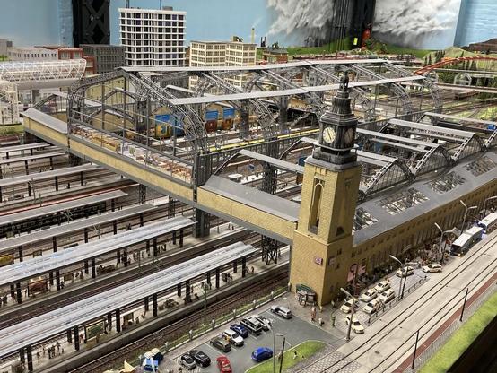
Das #MiWuLa wäre eine Schweine-Arbeit! Wenn sie helfen, mit Plänen und Dateien, wird es 50% leichter. Hat schon mal jemand von #OSM mit denen gesprochen? Einfach mal fragen ...
Einige Teile sind ja 1:1 nach gebaut, also in OSM schon vorhanden. Könnte man kopieren.
Es gibt 3D Renderer, wo Autos fahren. Züge noch nicht, gell? Dafür FOSS-Bahn-Spiele. Und das dann in der VR-Brille - wild zu einem virtuellen Rundgang. Träum ...
Weiter als #MicroMapping für die Geleise und Modellgebäude?! Da in #OpenStreetMap alles geht, geht auch alles in Miniatur. Was zeigen die 2D/3D Renderer da noch alles an? Terrain ist bei OSM ja noch mangelnd. Wie gehen in "echt" Tunnel und Berge? Selbst wenn 3D die height-tags berücksichtigt werden.
Die Standard- #VectorTiles reichen jedenfalls nicht. Aber man kann ja Zusätzliche parallel generieren.
Das #MiWuLa wäre eine Schweine-Arbeit! Wenn sie helfen, mit Plänen und Dateien, wird es 50% leichter. Hat schon mal jemand von #OSM mit denen gesprochen? Einfach mal fragen ...
Einige Teile sind ja 1:1 nach gebaut, also in OSM schon vorhanden. Könnte man kopieren.
Es gibt 3D Renderer, wo Autos fahren. Züge noch nicht, gell? Dafür FOSS-Bahn-Spiele. Und das dann in der VR-Brille - wild zu einem virtuellen Rundgang. Träum ...
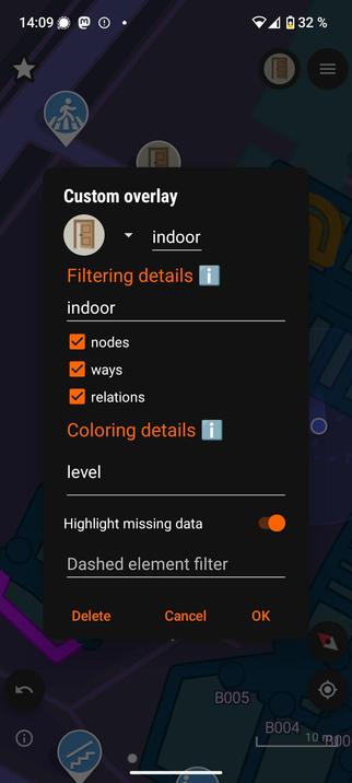
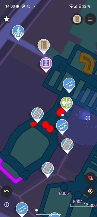
Indoor Mapping mit dem Smartphone und SCEE (Street Complete Expert Edition)

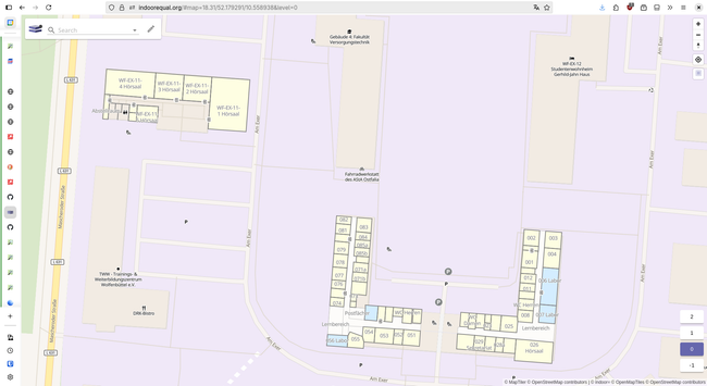
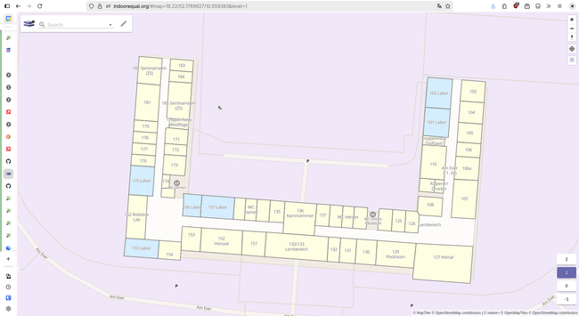
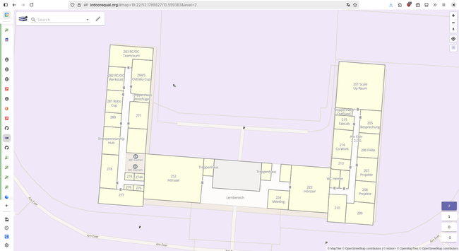
I'm currently mapping the #Ostfalia Campus in #Wolfenbüttel, Lower Saxony (Informatik Fakultät almost done 🥳) and i'm especially loving @francois 's tool indoor= to view it :)
https://indoorequal.org/#map=17.84/52.179237/10.559146&level=0
Great article by @VolkerKrause on #OpenStreetMap indoor-mapping using building plans:
https://www.volkerkrause.eu/2025/06/28/osm-mapping-building-interiors.html
Playing a bit with trying to implement indoor mapping support in libshumate (and ultimatly in Maps):
https://gitlab.gnome.org/GNOME/libshumate/-/tree/wip/mlundblad/indoor-levels
So far, one can manually edit a hard-coded value (in shumate/shumate-vector-renderer.c) and run the libshumate demo app, selecting the "OSM Liberty" map source alternative.
So, don't expect anything mature soon… 😄
#libshumate #gnomemaps #gnome #openstreetmap #mapstodon #indoormapping

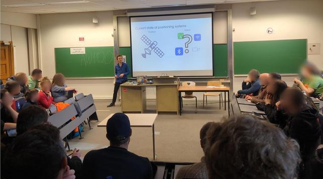
Talk by Maxim Van de Wynckel about #indoorMapping problems: #positioningSystem #beacons
and tools #OpenHPS #SemBeacon
By @maximvdw at #fosdem in the #geospatial devroom.
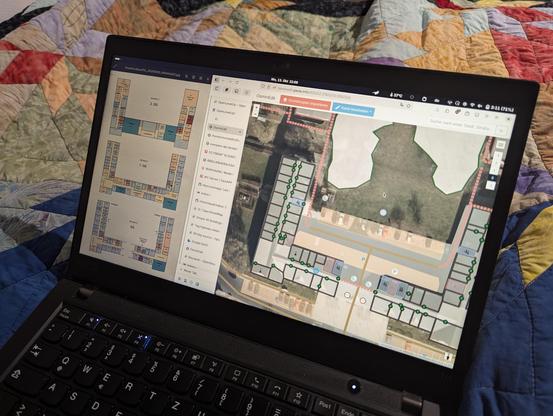
FOSS4Work: วาดแผนที่ในอาคารลงใน OpenStreetMap ด้วย OsmInEdit
YouTube: https://www.youtube.com/watch?v=qj14FdDJOqQ
TechTransThai Video: https://video.techtransthai.org/w/nh1SSZiC3ZY6LjoM7uRS6T
#foss4change #foss4work #techtransthai #openstreetmap #osminedit #indoormapping
YouTube: https://www.youtube.com/watch?v=qj14FdDJOqQ
TechTransThai Video: https://video.techtransthai.org/w/nh1SSZiC3ZY6LjoM7uRS6T
#foss4change #foss4work #techtransthai #openstreetmap #osminedit #indoormapping
