On the right is a senior living complex, Maple On Franklin (5.23 mi), 120 N Franklin St, and on the left is Franklin Square (5.22 mi), 140 N Franklin St, both in Holbrook MA, photographed from Buck Hill.

The two houses on the left are 127 and 123 N Franklin St. On the right is a house at 106 N Franklin St directly in front of the Abington Bank branch office, 95 N Franklin St.

#BuckHill #BlueHills #BlueHillsReservation #Boston #BostonMA #Holbrook #HolbrookMA #Landscape #LandscapePhotography #Photography #LongDistanceObservations #OlympusEM5 #CanonFD #500mm

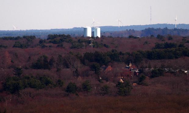
Four wind turbines, Cranberry Way, Kingston MA photographed from Buck Hill.

There is a cell tower almost exactly lined up with the first wind (left) turbine which I have not been able to identify. To the right of the first turbine is a water tower, 17 Kingston Collection Rd, Kingston MA. Directly in front of the second turbine are two water towers, 54 Sycamore St, Holbrook MA (there are in the foreground). There has been a third water tower constructed on this site since I took this photo. In between turbine two and the two water towers is another water tower, Silver Lake Regional Middle School, 256 Pembroke St, Kingston MA.

Just behind turbine 3 is a water tower, 100 Armstrong Rd, Plymouth MA. Between turbines 3 and 4 is a communication tower, Nicks Rock Road, Plymouth MA. Just left of turbine 4 and much smaller than Nicks Rock tower is a cell tower, 12 Richard's Rd, Plymouth MA.

At the bottom of the photograph is CATS Academy, Braintree MA, which was featured in an earlier post.

#BuckHill #BlueHills #BlueHillsReservation #Boston #BostonMA #Kingston #KingstonMA #Holbrook #HolbrookMA #Plymouth #PlymouthMA #Braintree #BraintreeMA #Landscape #LandscapePhotography #Photography #LongDistanceObservations #OlympusEM5 #CanonFD

Three water towers poke above the horizon and two church steeples below them, photographed from Buck Hill.

The water towers, from left to right are located at 306 High St, Pembroke MA, 50 Birch St, Duxbury MA, and 94 W Elm St, Pembroke MA. The distances are 18.4, 20.3, and 15.9 miles respectively.

The church on the left is the First Congregational Church In Rockland, 12 Church St, Rockland MA. The church on the right is the First Baptist Church of Rockland, 200 Union St, Rockland MA. According to Google Maps it would take four minutes to walk from one of the churches to the other.

The electric towers are adjacent to the National Grid substation at 435 Weymouth St, Holbrook MA.

#buckhill #bluehills #bluehillsreservation #boston #BostonMA #Pembroke #PembrokeMA #Duxbury #DuxburyMA #Rockland #RocklandMA #Holbrook #HolbrookMA #landscape #LandscapePhotography #photography #LongDistanceObservations

On the horizon is the Myles Standish Monument, Cresent St, Duxbury MA, photographed from Buck Hill.

In front of the monument is the Holy Family Church, 403 Union St and two water towers, 123 Rice Ave, both in the town of Rockland MA.

The large electric tower in the foreground is near 430 Weymouth St, Holbrook MA.

#buckhill #bluehills #bluehillsreservation #boston #BostonMA #DuxburyMA #RocklandMA #HolbrookMA #MylesStandish #MylesStandishMonument #landscape #LandscapePhotography #photography #LongDistanceObservations