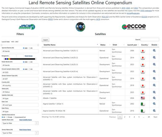
Land Remote Sensing Satellites Online Compendium [USGS]
--
https://www.usgs.gov/tools/land-remote-sensing-satellites-online-compendium <-- link to the compendium
--
https://calval.cr.usgs.gov/apps/compendium <-- direct entry point to search
--
#GIS #spatial #mapping #remotesensing #satelllite #opendata #data #inclusion #science #projects #earthobservation #library #JACIE #coordination #compendium #EROS #USGS #ECCOE #dictionary #RCAEO
--
https://www.usgs.gov/tools/land-remote-sensing-satellites-online-compendium <-- link to the compendium
--
https://calval.cr.usgs.gov/apps/compendium <-- direct entry point to search
--
#GIS #spatial #mapping #remotesensing #satelllite #opendata #data #inclusion #science #projects #earthobservation #library #JACIE #coordination #compendium #EROS #USGS #ECCOE #dictionary #RCAEO
Land Remote Sensing Satellites Online Compendium | U.S. Geological Survey
The Land Remote Sensing Satellites Online Compendium contains details about past, present and future Earth observing satellites and the sensors they carry. This information compiled by staff at the USGS Earth Resources Observation and Science (EROS) Center in Sioux Falls, South Dakota.