For #Day11 of the #30DayMapChallenge the theme is "red"! 🔴I plotted London bus stops using OpenStreetMap data in #rstats
Code: https://github.com/nrennie/30DayMapChallenge/blob/main/2022/scripts/11_red.R

| Work Website | www.veditum.org |
| instagram.com/dreamersid | |
| Rivers | #MovingUpstream |
| Trees | #FiftyTrees |
For #Day11 of the #30DayMapChallenge the theme is "red"! 🔴I plotted London bus stops using OpenStreetMap data in #rstats
Code: https://github.com/nrennie/30DayMapChallenge/blob/main/2022/scripts/11_red.R
Time. Aravalli Mountains, Rajasthan.
Do you know what has led to these formations?
Information courtesy of a few geologist friends. The feature is called 'Flatiron', and the triangular shapes are actually natural. Details here: https://en.wikipedia.org/wiki/Flatiron_(geomorphology)
Google Map co-ordinates: 27.253459, 76.127651

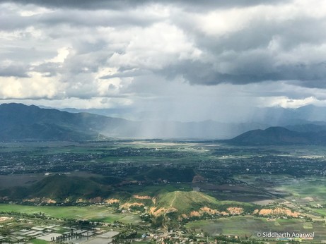
Green velvety hills of Manipur, and a patch on the hill showing signs of the slash and burn - Jhum cultivation practice.
If you know of any, please send interesting reading on the 'slash and burn practice'. From the Out of Eden Walk trail in Manipur. #EdenWalk #Manipur
A paddy party & natural sun-block. Rice fields, East of Imphal, Manipur.
From while walking with Paul Salopek in Manipur on his Out of Eden Walk project. It is a multi-year project where a 2 time Pulitzer prize winning journalist is walking across the world in the footsteps of our ancestors who first discovered the world.
Check out their website - www.outofedenwalk.org
&
contribute to their fundraiser if possible for you - http://outofedenwalknonprofit.org/matchcampaign/
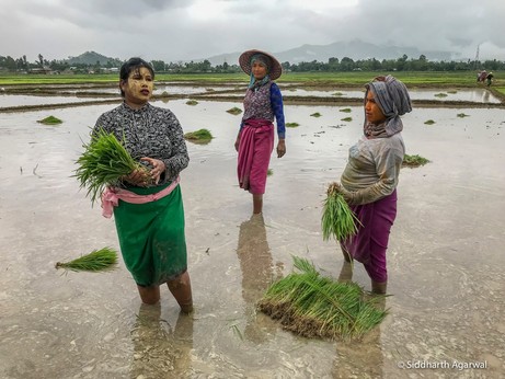
Time remaining in campaign: Help spread the word by sharing this page: A MESSAGE FROM PAUL DONOR REWARDS To show our sincere thanks for your contributions, we are assigning each mile along the Out of Eden Walk crowdfunding map a donor’s name. This digital map of supporters will remain a permanent legacy of the journey.... Read more »