Q-Rai

@qrai@chaos.social
116 Followers
125 Following
2.9K Posts

non-binary pan polyam kinky scientist

#cats #art #dinosaurs #TTRPG #dancing #BrazilianZouk #WestCoastSwing #DataScience #visualization #computing #DIY #WoodWorking

pronounsxe/dem or they/them (EN), dey/dem (DE)
languagesEN, DE
locationColorado, USA
Menschen die einen anderen Namen führen als bei ihrer Bank hinterlegt ist, das könnte für euch relevant sein. Ab Oktober müsen Banken bei Überweisungen den Namen mit der IBAN abgleichen ... https://www.mgp-steuerberater.de/iban-abgleich-mit-zahlungsempfaenger-ab-oktober-2025-was-sie-wissen-muessen/
Verification of Payee

Ab Oktober 2025 wird die EU-Verordnung „Verification of Payee“ (VoP) wirksam, die einen IBAN-Abgleich mit dem Zahlungsempfänger bei SEPA-Überweisungen vorschreibt. Diese Neuerung soll den Zahlungsverkehr sicherer machen und Betrug verhindern. Erfahren Sie, was Sie tun müssen, um sich vorzubereiten – von der Prüfung der Stammdaten bis zur richtigen Kommunikation mit Ihren Kunden. Verstehen Sie die praktischen Auswirkungen und Haftungsfragen im Falle von Falschüberweisungen.
Steuerberater Berlin – mgp Merla Ganschow & Partner mbB
@robertgarrigos umbrellas help some (definitely to reduce sunburn risk), but in the city, most surfaces you walk on heat up a lot when they're in the sunlight, and they radiate that heat. A surface that's not been in direct sunlight for a while will be cooler and more pleasant to walk on.
It's one aspect that leads to "urban heat islands" (aka cities are warmer than countryside), because surfaces like asphalt radiate more heat than a field. (Other factors include cars, air conditioning, etc)

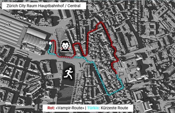
New blog post about "The coolest way to find shaded paths: Vampire routing on routing.osm.ch".

See https://sosm.ch/the-coolest-way-to-find-shady-paths-vampire-routing-on-routing-osm-ch/

#OSMinside #OpenStreetMap #Routing #UrbanHeat #SOSM

Root-Zugriff für alle: Kritische Sudo-Lücke gefährdet unzählige Linux-Systeme - Golem.de

Forscher haben eine gefährliche Sicherheitslücke im Kommandozeilentool Sudo entdeckt. Angreifer können mit wenig Aufwand Root-Rechte erlangen.

Golem.de
❤️ ☑️
@nachdemsturm oh gut. Das mach ich meistens auch, obwohl ich das Gerät habe.

@nachdemsturm Wichtig zu berücksichtigen bei der Planung: während Verwendung solltest du den gesamten Körper bedeckt halten. Lange Ärmel und Hosen/Schutzanzug, Handschuhe, Kopfbedeckung, Schutzbrille (idealerweise Goggles die seitlich schützen), Maske (mindestens die guten für Infektionsschutz, ich bevorzuge eine die unter "Respirator" fällt). Letztere beide sind Sicherheit, Rest einfacheres sauber bleiben, die Farbe landet echt überall.

Das wird WARM, insbesondere im Sommer.

@nachdemsturm Ich hab ein recht gutes Gerät (Preisrahmen um die $150). Wenn nicht allzu viel abzukleben ist (rechteckiger Raum, nicht zu viele Fenster und Türen) und die Wand zumindest ein bisschen Textur hat (Rauhfasertapete z.B.) klappt das ganz gut, aber es hat definitiv eine Lernkurve für die richtigen Settings. Nicht zu viel Farbe auf einmal, mehrere dünne Schichten. Wenn da zu viel Farbe ist, fließt die später die Wand runter und das sieht man.

Unfriendly #Pride reminder that rainbow capitalism is better than openly bigoted capitalism.

We *want* them to value our money more than our enemies' money. We want them to be ashamed of their right-wing executives, and to support their queer employees' Pride initiatives.

It helps literally keep us alive. Now more than ever, with diversity and inclusion programs getting shut down all over the place.

Pride cat 🌈 is here to give you a free timeline cleanser
×

New blog post about "The coolest way to find shaded paths: Vampire routing on routing.osm.ch".

See https://sosm.ch/the-coolest-way-to-find-shady-paths-vampire-routing-on-routing-osm-ch/

#OSMinside #OpenStreetMap #Routing #UrbanHeat #SOSM

@sfkeller „shady“ ist etwas vorbelastet mit der anderen Bedeutung als „zwielichtig“, dachte erst wieso will man einen zwielichtigen Weg bevorzugen 😅
Besser wäre vielleicht „shaded“ (dt. beschattet)?
@lx @sfkeller shady - zwielichtig - twilight - vampir
ich finds passend
@sfkeller “Luke, come to the dark side. You have no hat nor sunscreen”.
@sfkeller I might have not read thouroughly enough, but it seems like these routing calculations are currently limited to Switzerland. When I try it out with points in a German city it is setting a waypoint directing to Zurich in between.
Gladly no such option for vampires here.
@haecks @sfkeller I tried setting start and end points in my city in Poland and the route was through Switzerland too. Completely unexpected tbh
@daria @haecks Hi Daria. The “vampire mode” was implemented for the area of the city of Zurich on August 1 at 16:00 and made available on the servers of SOSM as a Proof-of-Concept.
@daria @haecks @sfkeller
… because it uses Switzerland-specific shading data. But maybe there is something similar for .de or .pl?
https://mastodon.social/@sfkeller/114821785088501038
Shadowmap | Sun-Powered Insights. Anywhere on Earth.

Your interface to the Sun: See the sunpath over your house. Visualize and analyze solar, architectural & real estate projects on our interactive 3D map.

@sfkeller I hope there will be a OpenStreetMap plugin for this
@sfkeller Great idea. I recently changed my cycle path to bike through the forest while it was so extremly hot. So a vampire mode for cycling would also be interesting.
@sfkeller Once in a blue moon, there suddenly is a REAL good app created! Very original and sophisticated: simple but very useful.

@sfkeller @lesekaffee Great!

What we need next is a "spirit mode" (also referred to as "ghost" or "phantom" mode), returning the shortest path between two points that is entirely uncovered by CCTV.

@Datterich @sfkeller @lesekaffee I've thought about that. In theory it's quite simple to avoid CCTV when routing, but the tagging scheme on OSM would have to change similar to how speed cameras are mapped. In most cases, only the cameras are mapped, but there is no relation to the surveiled ways. Calculating that based on the position and orientation would require a lot of processing and would result in many false positives.

#OSM #surveillance

@jomo @Datterich @lesekaffee That's a nice idea. Such an “enrichment” of route attributes would be an exciting Geo-DataOps task.
https://github.com/GIScience/osm-transform carries out such a preparation of OSM data. I am in the process of testing something similar in a student project with a view to special routing such as wheelchairs or emergency vehicles.
GitHub - GIScience/osm-transform: Filter, enrich and prepare your OSM data for openrouteservice 🚙

Filter, enrich and prepare your OSM data for openrouteservice 🚙 - GIScience/osm-transform

GitHub
@sfkeller how is that calculated? Building hight, orientation, street width and material, trees?
@Rhababerbarbar We used GRASS r.sun, which uses point clouds and a terrain model, including for mountain shadows. In our case, the point clouds are swissSURFACE and the terrain is swissALTI from swisstopo. And yes, swissSURFACE3D contains buildings with roofs, trees and vegetation. What is still missing in our calculation is the gradient of the road and the road surface material (surface).

@sfkeller

can't even express how much I love those techy nerdy independend and suporting FOSS projects!

@sfkeller can we maybe have this in @CoMaps?
@shisma @CoMaps Why not. Such an “enrichment” of route attributes is an Big-Geo-DataOps task. What route format can CoMap ingest? At first glance, I can only find KML and GPX.
@sfkeller SIngapore needs this, @cheeaun 🙂

@sohkamyung not easy 😁

I used to spent some time on this, mainly to avoid heat and also rain; looking at buildings (shadow) data, trees (crown shadow) data and covered walkpaths data. Still not enough. It probably works well for other cities, but for Singapore as a all-year-summer city-country, we have far more covered walk options (HDB open areas, underground passages, walking through malls, etc).

@sfkeller use an umbrella....
@robertgarrigos umbrellas help some (definitely to reduce sunburn risk), but in the city, most surfaces you walk on heat up a lot when they're in the sunlight, and they radiate that heat. A surface that's not been in direct sunlight for a while will be cooler and more pleasant to walk on.
It's one aspect that leads to "urban heat islands" (aka cities are warmer than countryside), because surfaces like asphalt radiate more heat than a field. (Other factors include cars, air conditioning, etc)
@sfkeller neat... but how about actually doing something against the heat?
Trees for example can do quite a bit to bring down the heat!
Make even australian city centers rather comfy to walk in...
@littlerao Right. After all, it's an index. At least trees are taken into account with this 'vampire' routing, too. Someone actually suggested calculating a 'shadeness' index for cities. This would allow you to measure advances in reducing heat over time.
@sfkeller lässt sich das irgendwie zu Graphhopper hinzufügen?
@T3Z Wieso nicht. Ist Big-Geo-DataOps. Unrealistisch wäre, das für jede Tagesstunde und jeden Ort der Welt zu rechnen. Da müsste ein gemittelter Schattenindex her. Oft fehlen Punktwolken und Geländemodelle. Wir verwendeten GRASS r.sun. osm-transform von GIScience HeiGIT leistet übrigens eine erste Anreicherung von OSM-Ways. Ich bin gerade dabei, ein ähnlicher Preprocessor wie osm-transform in einem Studentenprojekt zu testen mit Blick auf Spezialrouting wie Wheelchair oder Einsatzfahrzeuge.
@sfkeller @T3Z
Das wäre cool, freue mich schonmal vor!