OpenHistoricalMap

@ohm@mapstodon.space
640 Followers
502 Following
164 Posts

Explore the world throughout history – and local history, and prehistory. The #TimeMachine of maps, created by people like you and dedicated to the #PublicDomain. Charter project of @OpenStreetMapUS and companion to @openstreetmap.

Learn more: https://osm.wiki/OHM

(Mastodon account run by @jeffme @mxn and bridged as https://bsky.app/profile/ohm.mapstodon.space.ap.brid.gy )

#OpenHistoricalMap #OpenStreetMap #DigitalHumanities #OpenData #HGIS

Start mappinghttps://www.openhistoricalmap.org
GitHubhttps://github.com/OpenHistoricalMap
Blueskyhttps://bsky.app/profile/openhistoricalmap.org
Reddithttps://www.reddit.com/r/OpenHistoricalMap/

Labels on the map match your preferred language, just like the rest of the site. You can set your preferred language in settings. Now you can understand the map even if you don’t speak a language that was common halfway around the world centuries ago. For mappers, it’s a lot easier to see opportunities to improve our language coverage.

#localization #internationalization #multilingualism

Do you already contribute to @openstreetmap? You can start contributing to OpenHistoricalMap too in just a few clicks, without having to juggle yet another password for yet another mapping site. Once you have a taste of OSM #SingleSignOn via #OAuth2, you’ll never look back.
We’ve never seen such a sharp uptick in new railroad coverage like we’ve experienced in May, particularly in present-day Argentina, Finland, and Mexico.

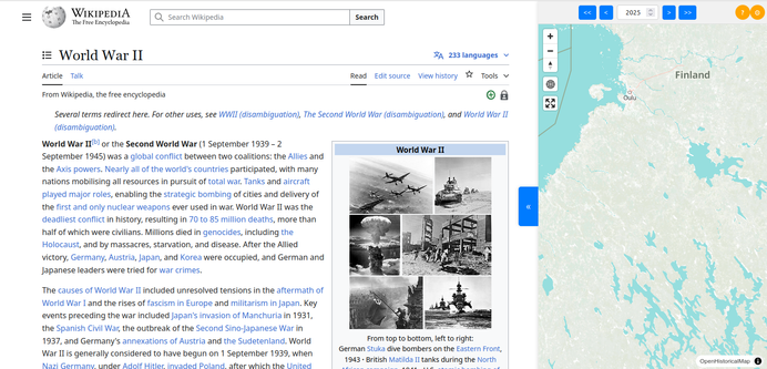
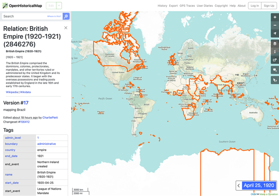
@aoppo whipped up a user script to easily navigate #OpenHistoricalMap while reading a #Wikipedia article. You can install it in your personal Wikipedia account:

https://globstory.it/wikipedia-user-script/

It’s one of many ideas for cooperation between the OHM and #Wikimedia communities:

https://meta.wikimedia.org/wiki/OpenHistoricalMap

Wikipedia User Script – GlobStory

Start and end #dates are very important for a #HistoricalGIS project. We managed to stuff dates into more of the website’s nooks and crannies, so you always know which stage of a boundary or building’s evolution you’re looking at, or whether it’s even the one you’re looking for.

#HGIS

Our #OSMCha instance makes it easy to inspect large changesets for subtle changes. Sometimes, those changes look very wrong, but only because modern aerial imagery doesn’t line up with the historical features being mapped.

Now you can visualize changesets against existing #OpenHistoricalMap coverage to see how it all fits into the map we’re building. Click the 🗺️ button to set the basemap back to #Mapbox or #BingMaps imagery like before.

https://osmcha.openhistoricalmap.org/

OSMCha

Validation tool for OpenStreetMap

OSMCha

Thanks to @bmacs001, #OpenHistoricalMap has comprehensive coverage of #NewJersey municipality boundaries over time. Watch the state get divvied up into counties, townships, boroughs, cities, towns, and villages in this mesmerizing #TimeSeries:

https://www.reddit.com/r/newjersey/comments/1j4e1od/the_evolution_of_new_jerseys_county_and_municipal/

#Boroughitis #JerseyFresh

It took @CharliePlett several months to map the British Empire and the hundreds of boundary changes involving its subdivisions and dependencies over the centuries. We’re a bit relieved it’s over – the huge boundary changes came close to melting the server a few times. Get a peek behind the scenes of this project from our intrepid mapper:

https://www.openhistoricalmap.org/user/CharliePlett/diary/35

#BritishEmpire

British Empire fully mapped

I started mapping on OpenHistoricalMap in 2019 because of things I had to erase on OpenStreetMap that I wanted recorded for histories sake.

OpenHistoricalMap

Anyone have a link to a mirror of the full resolution GSHHG national shoreline data? You know... just in case... asking for a friend.

https://www.ncei.noaa.gov/products/shoreline-coastline-resources

Shoreline/Coastline Resources

The Global Self-consistent, Hierarchical, High-resolution Geography database (GSHHG) is a shoreline dataset developed by scientists at the University of Hawaii (UH) and NOAA. The UH is the primary GSHHG site, though the dataset can also be accessed through NCEI.

National Centers for Environmental Information (NCEI)