Jimijamflimflam

@Jimijamflimflam@mstdn.social
520 Followers
589 Following
2.5K Posts

I’m Jimi.

I quietly contemplate these days. I enjoy reading about and infrequently discussing #SciFi, #Fantasy, #Horror, #Science, #USPolitics and #Noir. I’ve been #TentCamping over half my life.

#StarTrek🖖rocks.
I love all #Tolkien.
#MST3K is hilarious.
Michael Myers🔪the 1st shape.
#Ghibli storytelling is *gorgeous*
#Svengoolie rules!
Han shot first.

Early Gen X feral latchkey kid. Married. Mostly harmless. I block AI & jagbags.

We call them gym shoes round here.

HumanNot Immortal. Really.
LocationIn far Northern Illinois. Previously Braga, Pt., Funchal, Pt., Barrie, Ontario. Far Northern Illinois before all that.
Banner ImageFall is the season on the lakefront in Barrie, Ontario. A photographer in a yellow jacket sits under a reddish dynamic sculpture. New construction is visible in the background. Blue sky with scattered white clouds. The lake is reflecting the blue sky.
TootsToots disappear like tears in the rain. However it takes a while. So I got that going for me at least.
THEY’RE HUGE | A Giant-Sized MST3K Collection – Volume I

YouTube

Fantastic Adventures vol. 11, no. 9 (September 1949)

I like the kind of oblique/off-balance nature of this. They were focused on something in the foreground (something our hero had just shot?), looking out of the cover, until the plant-men interrupted them when they turned away from us. Also it looks rather friendly for an invasion.

Original magazine: https://archive.org/details/Fantastic_Adventures_v11n09_1949-09_unz.org

#Magazine #MagazineCover #PulpMagazine #PulpFiction #ScienceFiction #Fantasy #Horror #Art #Illustration

New findings from the NASA DART mission reveal that the impact on asteroid moon Dimorphos caused more complex effects than expected. (1/4) iopscience.iop.org/article/10.3... #DART #NASA #Hera #ESA #AsteroidDefence #Asteroid #Dimorphos #Meteorit

Radware Bot Manager Captcha

It's hard to swim in wellies and full SRT kit, so this is where my partner and I had to turn back in #GrotteDeGournier in #Vercors. We got right next to Salle Chevalier, meaning we'd covered about one third of the length of the passage. Next year, hiking boots & thicker wetstuit.

#caving

It is perfectly possible to look both feminine and dangerous. Another erinys drawing, mixing angelic and demonic traits.

I went big again on the hair, but also on the poofy sleeves—and the wings, naturally. I tried out a variety of different colour schemes, but after an accident with colour filling ended up going all in on pinks and peaches, to hopefully striking effect.

Hope folk like it.

#MastoArt #FediArt #Fantasy #Illustration #Erinys #Tiefling #Demon #Angel #ArtistsOnMastodon #Procreate

@stux

Rooftop solar, on just HALF of the world's roofs, would produce MORE electricity than is used today from ALL sources. And would uplift all people, strengthen all people, and drive a permanent economic boom.

Let every Neighbourhood become Saudi Arabia, but free.

#climate

https://theconversation.com/solar-panels-on-half-the-worlds-roofs-could-meet-its-entire-electricity-demand-new-research-169302

Solar panels on half the world’s roofs could meet its entire electricity demand – new research

India and China are the cheapest places to install rooftop solar, while the US, Japan and the UK are the most expensive.

The Conversation

I did a short video on this. For anyone who might need to hear, like, *logistical* reasons for why drafting people into farm work is bad.

https://youtu.be/jyVIqq4VBy4

Thread format to follow shortly.

Still early days for these lovely Bartelli tomatoes, but definitely going in the right direction!
23/365
#gardening #Photography

@youranoncentral.bsky.social

The coup has already happened and the people who wish to deconstruct the United States or doing so from within the White House.

Tech billionaires plan to take over cities and turn them into their nerd Riech fascist city states. Stopping them in the cities does two things it builds social power against those who would destroy us nationally

×

April 6, 2011

Dry Ice on Mars
by Melody

On Mars the seasonal polar caps are composed of dry ice (carbon dioxide). In the springtime as the sun shines on the ice, it turns from solid to gas and causes erosion of the surface. Dry ice goes directly from solid to vapor, unlike water ice which melts into liquid when it gets warm.

On Mars the seasonal polar caps are composed of dry ice (carbon dioxide). In the springtime as the sun shines on the ice, it turns from solid to gas and causes erosion of the surface. I enjoy the incredible diversity of forms that the erosion takes, and am studying the factors that give us "spiders", "caterpillars", or "starbursts", all colloquial words for what we rigorously name "araneiform" terrain.

This particular example shows eroded channels filled with bright ice, in contrast to the muted red of the underlying ground. In the summer the ice will disappear into the atmosphere, and we will see just the channels of ghostly spiders carved in the surface. This is truly Martian terrain - this type of erosion does not take place anywhere naturally on earth because our climate is too warm.

Credit:
NASA/JPL/University of Arizona

#space #mars #astrophotography #photography #science #astronomy #nature #NASA

Oct. 26, 2023

Distribution of Buried Ice on Mars

These Mars global maps show the likely distribution of water ice buried within the upper 3 feet (1 meter) of the planet's surface and represent the latest data from the Subsurface Water Ice Mapping project, or SWIM. SWIM uses data acquired by science instruments aboard three NASA orbital missions to estimate where ice may be hiding below the surface. Superimposed on the globes are the locations of ice-exposing meteoroid impacts, which provide an independent means to test the mapping results.

The ice-exposing impacts were spotted by the High-Resolution Imaging Science Experiment (HiRISE), a camera aboard NASA's Mars Reconnaissance Orbiter. While other instruments at Mars can only suggest where buried water ice is located, HiRISE's imagery of ice-exposing impacts can confirm where ice is present.

Most of these craters are no more than 33 feet (10 meters) in diameter, although in 2022 HiRISE captured a 492-foot-wide (150-meter-wide) impact crater that revealed a motherlode of ice that had been hiding beneath the surface. This crater is indicated with a circle in the upper-left portion of the right-most globe above.

Scientists can use mapping data like this to decide where the first astronauts on Mars should land: Buried ice will be a vital resource for the first people to set foot on Mars, serving as drinking water and a key ingredient for rocket fuel. It would also be a major scientific target: Astronauts or robots could one day drill ice cores much as scientists do on Earth, uncovering the climate history of Mars and exploring potential habitats (past or present) for microbial life.

Credit:
NASA Jet Propulsion Laboratory (JPL)

#space #mars #science #astronomy #physics #geology #nature #education #NASA

Dec 20, 2024

Avalanches, Icy Explosions, and Dunes:

NASA Is Tracking New Year on Mars
By NASA

[...]
“Springtime on Earth has lots of trickling as water ice gradually melts. But on Mars, everything happens with a bang,” said Serina Diniega, who studies planetary surfaces at NASA’s Jet Propulsion Laboratory in Southern California.

Mars’ wispy atmosphere doesn’t allow liquids to pool on the surface, like on Earth. Instead of melting, ice sublimates, turning directly into a gas. The sudden transition in spring means a lot of violent changes as both water ice and carbon dioxide ice — dry ice, which is much more plentiful on Mars than frozen water — weaken and break.

[...]

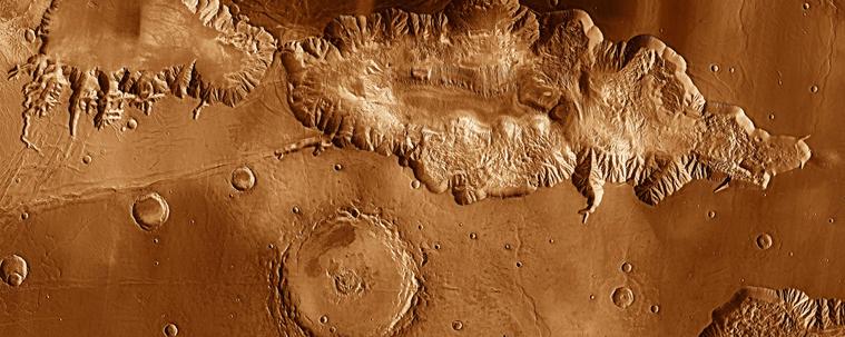
Using the cameras and other sensors aboard NASA’s Mars Reconnaissance Orbiter (MRO), which launched in 2005, scientists study all this activity to improve their understanding of the forces shaping the dynamic Martian surface. Here’s some of what they track.

In 2015, MRO’s High-Resolution Imaging Science Experiment (HiRISE) camera captured a 66-foot-wide (20-meter-wide) chunk of carbon dioxide frost in freefall. Chance observations like this are reminders of just how different Mars is from Earth, Diniega said, especially in springtime, when these surface changes are most noticeable.

[...]

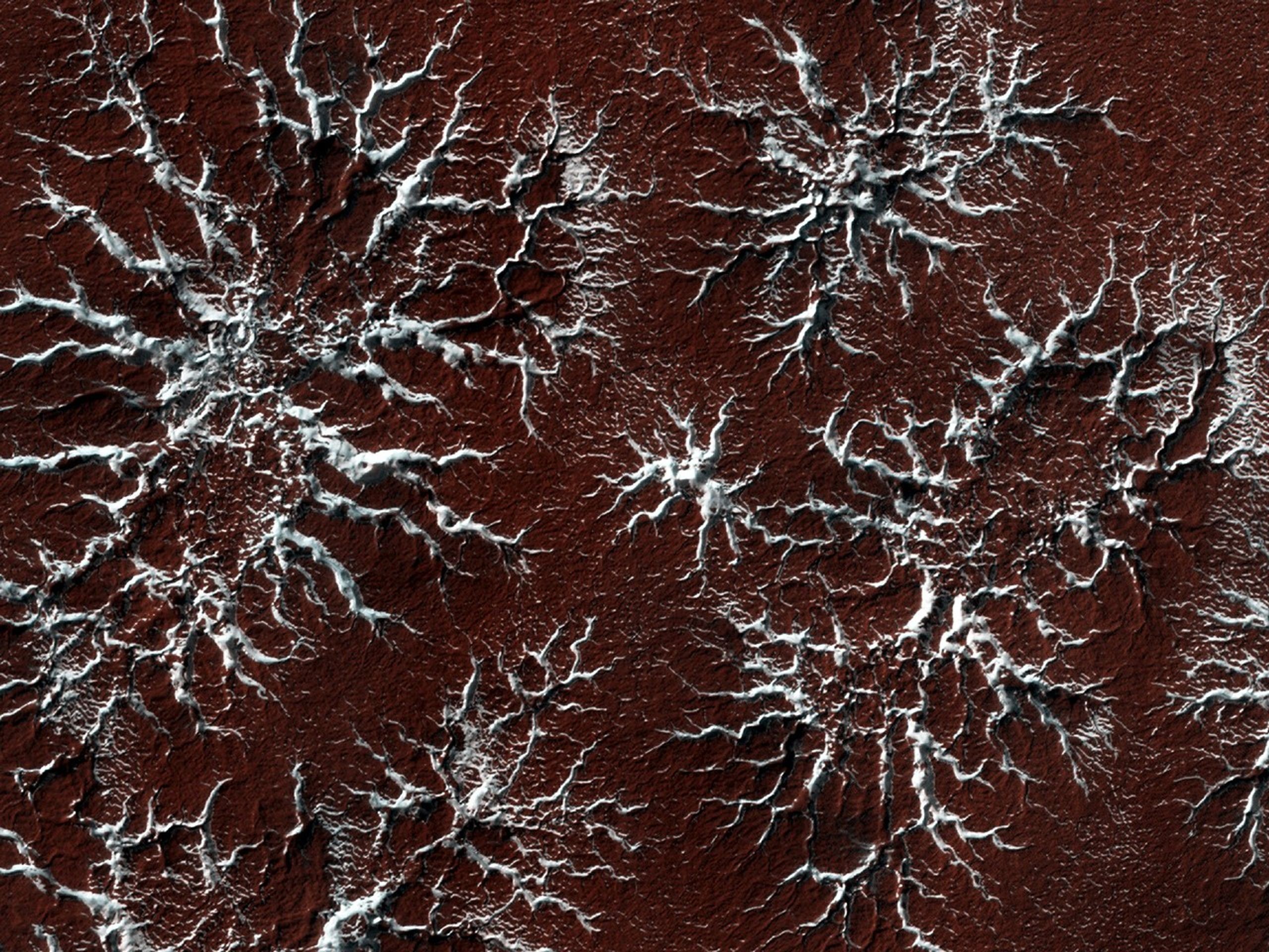
Diniega has relied on HiRISE to study another quirk of Martian springtime: gas geysers that blast out of the surface, throwing out dark fans of sand and dust. These explosive jets form due to energetic sublimation of carbon dioxide ice. As sunlight shines through the ice, its bottom layers turn to gas, building pressure until it bursts into the air, creating those dark fans of material.

But to see the best examples of the newest fans, researchers will have to wait until December 2025, when spring starts in the southern hemisphere. There, the fans are bigger and more clearly defined.
[...]

https://www.nasa.gov/missions/mars-reconnaissance-orbiter/avalanches-icy-explosions-and-dunes-nasa-is-tracking-new-year-on-mars/

#space #mars #astrophotography #photography #science #astronomy #physics #nature #NASA

2025 July 6

The Spiral North Pole of Mars
* Image Credit: ESA/DLR/FU Berlin; NASA MGS MOLA Science Team
http://www.esa.int/
http://www.dlr.de/pf/
http://www.fu-berlin.de/
https://www.nasa.gov/
https://mars.nasa.gov/programmissions/missions/past/globalsurveyor/
https://attic.gsfc.nasa.gov/mola/

Explanation:
Why is there a spiral around the North Pole of Mars? Each winter this pole develops a new outer layer about one meter thick composed of carbon dioxide frozen out of the thin Martian atmosphere. This fresh layer is deposited on a water-ice layer that exists year round. Strong winds blow down from above the cap's center and swirl due to the spin of the red planet -- contributing to Planum Boreum's spiral structure. The featured image is a perspective mosaic generated in 2017 from numerous images taken by ESA's Mars Express and elevations extracted from the laser altimeter aboard NASA's Mars Global Surveyor mission.
https://www.esa.int/ESA_Multimedia/Images/2017/02/Perspective_view_of_Mars_north_polar_ice_cap
!>>https://ilrs.gsfc.nasa.gov/lw16/docs/presentations/sci_6_Smith.pdf

https://en.wikipedia.org/wiki/Planum_Boreum
https://en.wikipedia.org/wiki/Katabatic_wind

https://apod.nasa.gov/apod/ap250706.html

#space #mars #astrophotography #photography #science #astronomy #geology #nature #NASA

"27 years ago, the first 3D visualizations of the North Pole of Mars were published and if you take into account the technical possibilities at that time and the resulting state of knowledge, then this image was a world sensation"

December 16, 1998

3-D Mars' North Pole
* Credit: MOLA Team, MGS Project, NASA
* Image: Greg Shirah (SVS)

Explanation:
This dramatic premier three-dimensional visualization of Mars' north pole is based on elevation measurements made by an orbiting laser. During the Spring and Summer of 1998 the Mars Orbiter Laser Altimeter (MOLA) flashed laser pulses toward the Martian surface from the Global Surveyor spacecraft and recorded the time it took to detect the reflection. This timing data has now been translated to a detailed topographic map of Mars' north polar terrain. The map indicates that the ice cap is is about 1,200 kilometers across, a maximum of 3 kilometers thick, and cut by canyons and troughs up to 1 kilometer deep. The measurements also indicate that the cap is composed primarily of water ice with a total volume of only about four percent of planet Earth's Antarctic ice sheet. In all it represents at most a tenth of the amount of water some scientists believe once existed on ancient Mars. Where did all the water go?

https://ilrs.gsfc.nasa.gov/lw16/docs/presentations/sci_6_Smith.pdf

https://apod.nasa.gov/apod/ap981216.html

#space #mars #astrophotography #photography #science #astronomy #geology #history #nature #NASA

Some laser-based toporaphic views of the surface of Mars

#space #mars #astrophotography #photography #science #astronomy #geology #topography #nature #NASA

Cappuccino swirls at Mars’ south pole

This picture is, perhaps surprisingly, from ESA’s Mars Express, which has been exploring and imaging the martian surface and atmosphere since 2003. We may be used to seeing numerous images of red and brown-hued soil and ruddy landscapes peppered with craters, but the Red Planet isn’t always so red.

The bright white region of this image shows the icy cap that covers Mars’ south pole, composed of frozen water and carbon dioxide. While it looks smooth in this image, at close quarters the cap is a layered mix of peaks, troughs and flat plains, and has been likened in appearance to swiss cheese.

The southern cap reaches some 3 km thick in places, and is around 350 km in diameter. This icy region is permanent; in the martian winter another, thinner ice cap forms over the top of it, stretching further out across the planet and disappearing again when the weather warms up.

The cap is around 150 km north of Mars’ geographical south pole and Mars Express has shed light on why this ice cap is displaced. Deep impact craters – notably the Hellas Basin, the largest impact structure on the entire planet at 7 km deep and 2300 km across – funnel the strong winds that blow across Mars towards its southern pole, creating a mix of different low- and high-pressure systems. The carbon dioxide in the polar cap sublimates at different rates in these regions with contrasting pressure, resulting in the cap’s lopsided structure.

Mars Express imaged this area of Mars on 17 December 2012, in infrared, green and blue light, using its High Resolution Stereo Camera. This image was processed by Bill Dunford, using data available from the ESA Planetary Science Archive.

CREDIT
ESA/DLR/FU Berlin / Bill Dunford

#space #mars #astrophotography #photography #science #astronomy #geology #topography #nature #NASA

Upper surface of icy layers covering Mars' south-polar region

This map shows the topography of the south polar region of Mars. The data were collected by the Mars Orbiter Laser Altimeter (MOLA) aboard NASA’s Mars Global Surveyor orbiter between 1997 and 2001.

The elevation of the terrain is shown by colors, with purple and blue representing the lowest areas, and orange and red the highest. The total range of elevation shown is about 5 kilometres. The black line shows the boundary of the south polar layered deposits, an ice-rich geologic unit that was probed by the Mars Advanced Radar for Subsurface and Ionospheric Sounding (MARSIS) aboard the European Space Agency's Mars Express orbiter between 2005 and 2006.

The radar data indicate that the deposit is more than 3.7 kilometres thick in places, and that the material consists of nearly pure water ice, with only a small component of dust. The MARSIS team also determined that the total volume of ice in the layered deposits is equivalent to a water layer 11 metres deep, if spread evenly across the planet. The boundary of the layered deposits was mapped by scientists from the U.S. Geological Survey. The dark circle in the upper center is the area pole-ward of 87 ° south latitude, where MARSIS data cannot be collected. The image covers an area 1670 by 1800 kilometres.

CREDIT
NASA/MOLA Science Team

#space #mars #astrophotography #photography #science #astronomy #geology #topography #nature #NASA

Hebes Chasma, perspective view

Perspective view of Hebes Chasma obtained by the High Resolution Stereo Camera (HRSC) on ESA’s Mars Express spacecraft.
Hebes Chasma is located at approximately 1° south and 282° east. The HRSC obtained image data on 16 September 2005 with a ground resolution of approximately 15 m/pixel.

CREDIT
ESA/DLR/FU Berlin (G. Neukum)

#space #mars #astrophotography #photography #science #astronomy #geology #topography #nature #NASA

2017 May 28

Collapse in Hebes Chasma on Mars
* Image Credit & License: ESA/DLR/FU Berlin (G. Neukum)
http://www.esa.int/
http://www.dlr.de/pf/
http://www.fu-berlin.de/
https://www.esa.int/Science_Exploration/Space_Science/People/Man_with_a_plan_An_interview_with_Gerhard_Neukum

Explanation:
What's happened in Hebes Chasma on Mars? Hebes Chasma is a depression just north of the enormous Valles Marineris canyon. Since the depression is unconnected to other surface features, it is unclear where the internal material went. Inside Hebes Chasma is Hebes Mensa, a 5 kilometer high mesa that appears to have undergone an unusual partial collapse -- a collapse that might be providing clues. The featured image, taken by ESA's robotic Mars Express spacecraft currently orbiting Mars, shows great details of the chasm and the unusual horseshoe shaped indentation in the central mesa. Material from the mesa appears to have flowed onto the floor of the chasm, while a possible dark layer appears to have pooled like ink on a downslope landing. A recent hypothesis holds that salty rock composes some lower layers in Hebes Chasma, with the salt dissolving in melted ice flows that drained through holes into an underground aquifer.
https://en.wikipedia.org/wiki/Hebes_Chasma
!>>http://geomorphology.sese.asu.edu/Papers/Adams_etal_hebes_chasma_salt_tectonics_geol.pdf

https://en.wikipedia.org/wiki/Aquifer

https://apod.nasa.gov/apod/ap170528.html

#space #mars #astrophotography #photography #science #astronomy #geology #topography #nature #NASA

From Wikipedia, the free encyclopedia

Hebes Chasma

is an isolated chasma just north of the Valles Marineris canyon system of Mars. It is centered at 1 degree southern latitude and 76 degrees western longitude, just between the Martian equator and the Valles Marineris system, just east of the Tharsis region.

Hebes Chasma is a completely closed depression in the surface of Mars, with no outflows to the nearby Echus Chasma to the west, Perrotin Crater to the southwest, or Valles Marineris to the south. Its maximum extents are approximately 320 km east to west, 130 km north to south, and 5 to 6 km in depth. At the center of the depression is Hebes Mensa, a large mesa rising some 5 km off the valley floor, nearly as high as the surrounding terrain. This central plateau makes Hebes Chasma a unique valley in Martian geography.

The word Hebes comes from Hebe, the goddess of youth, who was the daughter of Zeus and Hera. Hebe was the wife of Hercules.

The walls of Hebes Chasma weather differently than the slopes on the mesa on its floor. Also, studies of the thermal inertia suggest that the mesa and the walls of the canyon are made of different substances. Thermal inertia is how long the surface holds heat. For example, rocky areas will stay warmer than dust at night. One popular idea that explains the difference between the depression's walls and the mesa slopes is that the mesa was formed from material that accumulated in a lake.

https://en.wikipedia.org/wiki/Hebes_Chasma

#space #mars #astrophotography #photography #science #astronomy #geology #topography #nature #NASA

2014 May 11

Valles Marineris: The Grand Canyon of Mars
* Image Credit: Viking Project, USGS, NASA
https://nssdc.gsfc.nasa.gov/planetary/viking.html
https://www.usgs.gov/
http://www.nasa.gov/

Explanation:
The largest canyon in the Solar System cuts a wide swath across the face of Mars. Named Valles Marineris, the grand valley extends over 3,000 kilometers long, spans as much as 600 kilometers across, and delves as much as 8 kilometers deep. By comparison, the Earth's Grand Canyon in Arizona, USA is 800 kilometers long, 30 kilometers across, and 1.8 kilometers deep. The origin of the Valles Marineris remains unknown, although a leading hypothesis holds that it started as a crack billions of years ago as the planet cooled. Several geologic processes have been identified in the canyon. This mosaic was created from over 100 images of Mars taken by Viking Orbiters in the 1970s.

https://en.wikipedia.org/wiki/Valles_Marineris
https://www.windows2universe.org/mars/interior/Valles_Marineris.html
https://nssdc.gsfc.nasa.gov/photo_gallery/photogallery-mars.html
https://science.nasa.gov/mars/facts/

https://apod.nasa.gov/apod/ap140511.html

https://apod.nasa.gov/apod/ap140511.html

#space #mars #astrophotography #photography #science #astronomy #geology #topography #nature #NASA