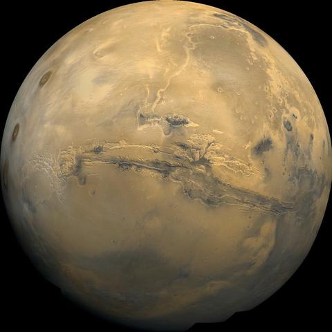
TOPIC>
Mars

2025 June 15
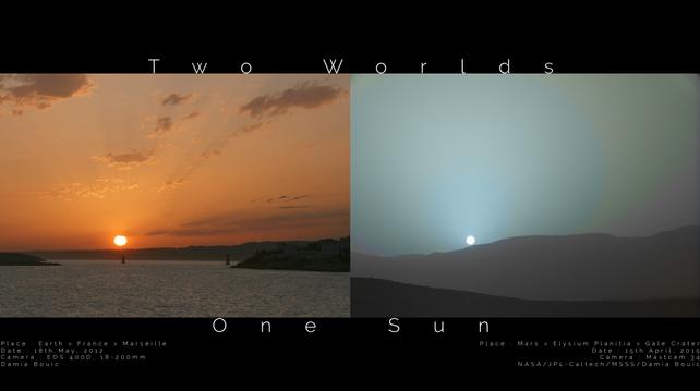
Two images are shown side by side. On the left is a sunset seen from Earth, while on the right is a sunset seen from Mars. The Earth sunset is quite orange, while the Mars sunset is quite blue. The Sun appears angularly smaller from Mars than from the Earth.

Two Worlds, One Sun
* Left Image Credit & Copyright: Damia Bouic
https://www.planetary.org/profiles/damia-bouic
* Right Image Credit: NASA, JPL-Caltech, MSSS
https://www.msss.com/
* Digital processing: Damia Bouic

Explanation:
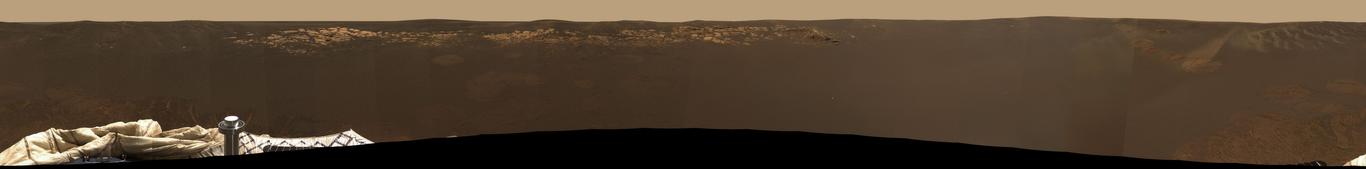
How different does sunset appear from Mars than from Earth? For comparison, two images of our common star were taken at sunset, one from Earth and one from Mars. These images were scaled to have the same angular width and are featured here side-by-side. A quick inspection will reveal that the Sun appears slightly smaller from Mars than from Earth. This makes sense since Mars is 50% further from the Sun than Earth. More striking, perhaps, is that the Martian sunset is noticeably bluer near the Sun than the typically orange colors near the setting Sun from Earth. The reason for the blue hues from Mars is not fully understood, but thought to be related to forward scattering properties of Martian dust. The terrestrial sunset was taken in 2012 March from Marseille, France, while the Martian sunset was captured in 2015 by NASA's robotic Curiosity rover from Gale crater on Mars.
https://www.db-prods.net/blog/2015/05/06/coucher-de-soleil-sur-mars/
https://www.planetary.org/articles/0506-sunset-on-mars
https://apod.nasa.gov/apod/ap140302.html
https://science.nasa.gov/mars/facts/
https://en.wikipedia.org/wiki/Mars
https://en.wikipedia.org/wiki/Gale_%28crater%29
https://en.wikipedia.org/wiki/Martian_regolith#Atmospheric_dust
https://science.nasa.gov/mission/msl-curiosity/

https://www.physicsclassroom.com/class/light/Lesson-2/Blue-Skies-and-Red-Sunsets
https://en.wikipedia.org/wiki/Astronomy_on_Mars#The_color_of_the_sky

https://www.youtube.com/watch?v=IXSIZcj8WgA
https://www.msss.com/

https://science.nasa.gov/sun/
https://hudsonvalleygeologist.blogspot.com/2012/04/size-of-sun.html

https://apod.nasa.gov/apod/ap220206.html
https://science.nasa.gov/earth/
https://apod.nasa.gov/apod/ap980526.html

https://apod.nasa.gov/apod/ap250615.html

#space #mars #sun #earth #astrophotography #photography #science #astronomy #nature #NASA #physics

Mars missions: A brief history
By Elizabeth Howell, Vicky Stein, Daisy Dobrijevic

Mars missions have been launching for over 50 years but not every mission ends in success.

Mars missions have been launching from Earth with regularity since the 1960s, bent on exploring our planetary neighbor. With its potential for liquid water — and therefore, life — Mars is an alluring target.

But it's a difficult journey, and only about half of all Mars missions successfully make it to the Red Planet, according to NASA. A "Great Galactic Ghoul" must be consuming them, joked a journalist and a NASA scientist corresponding in 1964, reported the Economist.

Since the first successful flyby in 1965, several space agencies have successfully made it to Mars. NASA, the former Soviet Union space program, the European Space Agency (ESA) and the Indian Space Research Organization each met with earlier successes.

A significant batch of Mars-bound missions arrived in February 2021. NASA's Perseverance rover and Ingenuity helicopter reached Mars that month, along with the United Arab Emirates' Hope orbiter (a first interplanetary mission for that country) and the China National Space Administration's Tianwen-1 orbiter and lander-rover mission, which was China's first successful mission to the Red Planet.

Coming up in the 2020s and 2030s, the Japan Aerospace Exploration Agency (JAXA) is planning a sample-return mission from Mars' moon Phobos, and NASA has teamed up with the ESA on a sample-return mission from Mars itself.

Read more:>>
https://www.space.com/13558-historic-mars-missions.html

#space #mars #earth #astrophotography #photography #science #astronomy #nature #NASA

https://youtu.be/7aKewWHXXRE

“Landing on Mars”
(59 min)

In the summer of 2003, two NASA rovers began their journeys to Mars at a time when the Red Planet and Earth were the nearest they had been to each other in 60,000 years. To capitalize on this alignment, the rovers had been built at breakneck speed by teams at NASA’s Jet Propulsion Laboratory. The mission came amid further pressures, from mounting international competition to increasing public scrutiny following the loss of the space shuttle Columbia and its crew of seven. NASA was in great need of a success.

“Landing on Mars” is the story of Opportunity and Spirit surviving a massive solar flare during cruise, the now well-known “six minutes of terror,” and what came close to being a mission-ending software error for the first rover once it was on the ground.

#space #mars #sun #earth #astrophotography #photography #science #astronomy #nature #NASA #physics

JPL and the Space Age: Landing on Mars

YouTube

https://eyes.nasa.gov/apps/solar-system/#/mars

"This link will take you directly to the maximized full screen of the interactive 3D simulation with many different options. Have fun exploring .."

The fourth planet from the Sun, Mars is a dusty, cold, desert world with a very thin atmosphere.
Mars was named by the ancient Romans for their god of war because its reddish color was reminiscent of blood. The Red Planet is actually many colors. At the surface we see colors such as brown, gold and tan. The reason Mars looks reddish is due to oxidization—or rusting—of iron in the rocks, regolith (Martian “soil”), and dust of Mars. This dust gets kicked up into the atmosphere and from a distance makes the planet appear mostly red. Mars is home to the largest volcano in the solar system, Olympus Mons. It's three times taller than Earth's Mt. Everest with a base the size of the state of New Mexico.
Mars appears to have had a watery past, with ancient river valley networks, deltas and lakebeds, as well as rocks and minerals on the surface that could only have formed in liquid water. Some features suggest that Mars experienced huge floods about 3.5 billion years ago. There is water on Mars today, but the Martian atmosphere is too thin for liquid water to exist for long on the surface. Today, water on Mars is found in the form of water-ice just under the surface in the polar regions as well as in briny (salty) water, which seasonally flows down some hillsides and crater walls.
No planet beyond Earth has been studied as intensely as Mars. Today, a science fleet of robotic spacecraft study Mars from all angles.

#space #mars #sun #earth #astrophotography #photography #science #astronomy #nature #NASA

Eyes on the Solar System - NASA/JPL

Explore the 3D world of the Solar System. Learn about past and future missions.

Eyes on the Solar System - NASA/JPL

Curiosity wraps up an investigation at Mars' Pink Cliffs while trying out a style of exploration used by geologists on Earth called “the walkabout.”

Part of NASA's Mars Science Laboratory mission, Curiosity, was the largest and most capable rover ever sent to Mars when it launched in 2011. Curiosity set out to answer the question: Did Mars ever have the right environmental conditions to support small life forms called microbes? Early in its mission, Curiosity's scientific tools found chemical and mineral evidence of past habitable environments on Mars. It continues to explore the rock record from a time when Mars could have been home to microbial life.

https://science.nasa.gov/mission/msl-curiosity/

#space #mars #sun #earth #science #astronomy #geology #tech #nature #NASA #MarsRoverCuriosity

https://youtu.be/sbfODUMgfcw

Drag your mouse or move your phone to explore this 360-degree panorama provided by NASA’s Curiosity Mars rover.

3D Model of a Curiousity Rover to explore it from all sides >>
https://solarsystem.nasa.gov/gltf_embed/2398/?height=450&rotate=true&cc=true&fs=true&target=&orbit=

#space #mars #sun #earth #astrophotography #photography #science #tech #nature #NASA

Curiosity Rover Leaves Gediz Vallis Channel (360 View)

YouTube

2025 June 21

Two Worlds, Two Analemmas
* Image Credit: (left) Copyright: Tunc Tezel (TWAN) https://twanight.org/profile/tunc-tezel/ - (right): NASA/JPL/Cornell/ASU/TAMU https://www.nasa.gov/

Explanation:
Sure, that figure-8 shaped curve you get when you mark the position of the Sun in Earth's sky at the same time each day over one year is called an analemma. On the left, Earth's figure-8 analemma was traced by combining wide-angle digital images recorded during the year from December 2011 through December 2012. But the shape of an analemma depends on the eccentricity of a planet's orbit and the tilt of its axis of rotation, so analemma curves can look different for different worlds. Take Mars for example. The Red Planet's axial tilt is similar to Earth's, but its orbit around the same sun is more eccentric (less circular) than Earth's orbit. As seen from the Martian surface, the analemma traced in the right hand panel is shaped more like a tear drop. The Mars rover Opportunity captured the images used over the Martian year corresponding to Earth dates July 2006 to June 2008. Of course, each world's solstice dates still lie at the top and bottom of their different analemma curves. The last Mars northern summer solstice was May 29, 2025. Our fair planet's 2025 northern summer solstice is at June 21, 2:42 UTC.

Earth:
https://apod.nasa.gov/apod/ap131014.html
https://apod.nasa.gov/apod/ap241204.html
https://apod.nasa.gov/apod/ap250320.html

Mars:
https://www.planetary.org/articles/a-martian-analemma
https://www.planetary.org/articles/mars-calendar

https://en.wikipedia.org/wiki/Analemma#Seen_from_other_planets
https://analemma.com/other-analemmas.html

https://apod.nasa.gov/apod/ap250621.html

#space #mars #sun #earth #astrophotography #photography #science #astronomy #nature #NASA #physics

2025 June 22

A Berry Bowl of Martian Spherules
* Image Credit: NASA, JPL, Curiosity Rover
https://science.nasa.gov/mission/msl-curiosity/
https://www.jpl.nasa.gov/
https://www.nasa.gov/

Explanation:
How were these unusual Martian spherules created? Thousands of unusual gray spherules made of iron and rock and dubbed blueberries were found embedded in and surrounding rocks near the landing site of the robot Opportunity rover on Mars in 2004. To help investigate their origin, Opportunity found a surface dubbed the Berry Bowl with an indentation that was rich in the Martian orbs. The Berry Bowl is pictured here, imaged during rover's 48th Martian day. The average size of a Martian blueberry rock is only about 4 millimeters across. By analyzing a circular patch in the rock surface to the left of the densest patch of spherules, Opportunity obtained data showing that the underlying rock has a much different composition than the hematite rich blueberries. This information contributes to the growing consensus that these small, strange, gray orbs were slowly deposited from a bath of dirty water.
https://photojournal.jpl.nasa.gov/catalog/PIA05634
https://science.nasa.gov/mission/msl-curiosity/location-map/
https://ui.adsabs.harvard.edu/abs/2017Icar..289..144W/abstract

https://apod.nasa.gov/apod/ap040303.html
https://apod.nasa.gov/apod/ap040210.html
https://apod.nasa.gov/apod/ap040216.html
https://science.nasa.gov/resource/martian-blueberries-2/
Martian_spherules

https://periodic.lanl.gov/26.shtml
https://en.wikipedia.org/wiki/Hematite

https://apod.nasa.gov/apod/ap250622.html

#space #mars #rover #astrophotography #photography #science #geology #nature #NASA

March 5, 2024: NASA released images of transits of the moon Deimos, the moon Phobos and the planet Mercury as viewed by the Perseverance rover on the planet Mars.

Solar 'eclipses' on Mars

The two moons of Mars, Phobos and Deimos, are much smaller than Earth's Moon, greatly reducing the frequency of solar eclipses on that planet. Neither moon's apparent diameter is large enough to cover the disk of the Sun, and therefore they are annular solar eclipses and can also be considered transits.

Eclipses caused by Phobos

Due to the small size of Phobos (about 20 by 25 km (12 by 16 mi)) and its rapid orbital motion, an observer on the surface of Mars would never experience a solar eclipse for longer than about thirty seconds. Phobos also takes only 7 hours 39 minutes to orbit Mars, while a Martian day is 24 hours 37 minutes long, meaning that Phobos can create two eclipses per Martian day. These are annular eclipses, because Phobos is not quite large enough or close enough to Mars to create a total solar eclipse.

Transits caused by Deimos

Deimos is too small (about 15 by 10 km (9.3 by 6.2 mi)) and too far from Mars to cause an eclipse. The best an observer on Mars would see is a small spot crossing the Sun's disc.

Transit of Mercury

A transit of Mercury across the Sun as seen from Mars takes place when the planet Mercury passes directly between the Sun and Mars, obscuring a small part of the Sun's disc for an observer on Mars. During a transit, Mercury can be seen from Mars as a small black disc moving across the face of the Sun.

The Mercury-Mars synodic period is 100.888 days. It can be calculated using the formula 1/(1/P-1/Q), where P is the orbital period of Mercury (87.969 days) and Q is the orbital period of Mars (686.98 days).

Credits:
Excerpts from Wikipedia articles

#space #mars #PerseveranceRover #astrophotography #photography #science #astronomy #NASA

Mars Exploration Rovers: Spirit and Opportunity
* Occurred 6 years ago

NASA’s Spirit and Opportunity rovers were identical twin robots that helped rewrite our understanding of the early history of Mars.

Landing Sites

The rovers were targeted to land at sites on opposite sides of Mars that looked as though they were affected by liquid water in the past. Spirit landed at Gusev Crater, a possible former lake in a giant impact crater. Opportunity landed at Meridiani Planum, a place where mineral deposits suggested that Mars had a wet history.

Mars Exploration Rovers In Depth

Rover Basics:
Each robotic explorer sent to the Red Planet has its own unique capabilities driven by science. Many attributes of a rover take on human-like features, such as “heads,” and “bodies.”
https://science.nasa.gov/planetary-science/programs/mars-exploration/rover-basics/

Objectives:
New knowledge from the twin rovers uniquely contributed to meeting the four overarching goals of the Mars Exploration Program, while complementing data gathered through other Mars missions.
https://science.nasa.gov/mission/mars-exploration-rovers-spirit-and-opportunity/science-objectives/

Science:
By studying the rock record, Spirit and Opportunity confirmed that water was long standing on the surface of Mars in ancient times.
https://science.nasa.gov/mission/mars-exploration-rovers-spirit-and-opportunity/science-highlights/

Resources:
Visit the one-stop-shop for all Spirit and Opportunity multimedia.
https://science.nasa.gov/mars/resources/?search=spirit+opportunity

This infographic highlights NASA’s twin robot geologists, the Mars Exploration Rovers (MER) Spirit and Opportunity. The rovers landed on the Red Planet in 2004, in search of answers about the history of water on Mars. Spirit concluded its mishttps://science.nasa.gov/mission/mars-exploration-rovers-spirit-and-opportunity/sion in 2010. Opportunity last communicated with Earth on June 10, 2018, as a planet-wide dust storm blanketed the solar-powered rover's location on Mars.

Credit:
NASA/JPL-Caltech

https://science.nasa.gov/mission/mars-exploration-rovers-spirit-and-opportunity/

#space #mars #rover #astrophotography #photography #science #astronomy #NASA

https://solarsystem.nasa.gov/gltf_embed/2370/?height=450&rotate=true&cc=true&fs=true&target=&orbit=

A 3D model of the twin Mars Exploration Rovers, Spirit and Opportunity.
NASA Visualization Technology Applications and Development (VTAD)

#space #mars #rover #astrophotography #photography #science #astronomy #NASA

Mars Exploration Rovers 3D Model – NASA Solar System Exploration

2004 February 4

Opportunity's Horizon
* Credit: Mars Exploration Rover Mission, JPL, NASA
https://science.nasa.gov/mission/mars-exploration-rovers-spirit-and-opportunity/
http://www.jpl.nasa.gov/index.html
http://www.nasa.gov/home/index.html

Explanation:
Remarkably, the Opportunity Mars rover lies in a small martian impact crater about 3 meters deep and 22 meters wide. For 360 degrees, Opportunity's horizon stretches to the right in this color mosaic image from the rover's panoramic camera. Notable in this view of the generally dark, smooth terrain are surface imprints left by the lander's airbags and an outcropping of light-colored, layered rock about 8 meters away toward the northwest. Though they look imposing, the rocks in the tantalizing outcrop are only a few centimeters high and will be dwarfed by the cart-sized rover itself during future close-up investigations. Opportunity has now rolled off its lander and, along with the restored Spirit rover, is directly exploring the martian surface.
https://apod.nasa.gov/apod/ap040126.html
https://apod.nasa.gov/apod/ap040114.html

https://apod.nasa.gov/apod/ap040204.html

#space #mars #rover #astrophotography #photography #science #astronomy #nature #NASA

2025 June 29

Dark Sand Cascades on Mars
* Image Credit: NASA, HiRISE, MRO, LPL (U. Arizona),
https://www.lpl.arizona.edu/
https://science.nasa.gov/mission/mars-reconnaissance-orbiter/
http://hirise.lpl.arizona.edu/
http://www.nasa.gov/

Explanation:
Are these trees growing on Mars? No. Groups of dark brown streaks have been photographed by the Mars Reconnaissance Orbiter on melting pinkish sand dunes covered with light frost. The featured image was taken in 2008 April near the North Pole of Mars. At that time, dark sand on the interior of Martian sand dunes became more and more visible as the spring Sun melted the lighter carbon dioxide ice. When occurring near the top of a dune, dark sand may cascade down the dune leaving dark surface streaks -- streaks that might appear at first to be trees standing in front of the lighter regions but cast no shadows. Objects about 25 centimeters across are resolved on this image spanning about one kilometer. Close ups of some parts of this image show billowing plumes indicating that the sand slides were occurring even while the image was being taken.
https://hirise.lpl.arizona.edu/PSP_007962_2635
https://www.nasa.gov/image-article/martian-sand-dunes-spring/
https://apod.nasa.gov/apod/ap080311.html
https://www.jpl.nasa.gov/news/recurring-martian-streaks-flowing-sand-not-water/
https://apod.nasa.gov/apod/ap070805.html
https://apod.nasa.gov/apod/ap021224.html

https://en.wikipedia.org/wiki/Mars_Reconnaissance_Orbiter

https://apod.nasa.gov/apod/ap250629.html

#space #mars #astrophotography #photography #science #astronomy #nature #NASA

2006 August 23

Sandy Gas Jets Hypothesized on Mars
* Illustration Credit & Copyright: Ron Miller (ASU)
https://sese.asu.edu/

Explanation:
What's causing seasonal dark spots on Mars? Every spring, strange dark spots appear near the Martian poles, and then vanish a few months later. These spots typically span 50 meters across and appear fan shaped. Recent observations made with THEMIS instrument onboard NASA's Mars Odyssey, currently orbiting Mars, found the spots to be as cold as the carbon dioxide (CO2) ice beneath them. Based on this evidence, a new hypothesis has been suggested where the spots are caused by explosive jets of sand-laden CO2. As a pole warms up in the spring, frozen CO2 on the surface thins, perforates, and begins to vent gaseous CO2 held underneath. Within this hypothesis, interspersed dark sand would explain the color of the spots, while the underlying frozen CO2 would explain the coolness of the spots. Pictured above, an artist depicts what it might be like to stand on Mars and witness the venting of these tremendous gas and dust jets.

https://science.nasa.gov/mission/odyssey/
https://en.wikipedia.org/wiki/Carbon_dioxide
https://en.wikipedia.org/wiki/Dry_ice#Solid_CO2
https://photojournal.jpl.nasa.gov/catalog/PIA08660

https://apod.nasa.gov/apod/ap060823.html

#space #mars #astrophotography #photography #science #astronomy #nature #NASA

"This Martian Professor explains an exciting hypothesis about the effect of dry ice on the Martian surface at the seasonal polar caps"

Video Credit:
mr_JDog75
https://www.youtube.com/@mrbrunnerutah

#space #mars #science #nature #NASA

April 6, 2011

Dry Ice on Mars
by Melody

On Mars the seasonal polar caps are composed of dry ice (carbon dioxide). In the springtime as the sun shines on the ice, it turns from solid to gas and causes erosion of the surface. Dry ice goes directly from solid to vapor, unlike water ice which melts into liquid when it gets warm.

On Mars the seasonal polar caps are composed of dry ice (carbon dioxide). In the springtime as the sun shines on the ice, it turns from solid to gas and causes erosion of the surface. I enjoy the incredible diversity of forms that the erosion takes, and am studying the factors that give us "spiders", "caterpillars", or "starbursts", all colloquial words for what we rigorously name "araneiform" terrain.

This particular example shows eroded channels filled with bright ice, in contrast to the muted red of the underlying ground. In the summer the ice will disappear into the atmosphere, and we will see just the channels of ghostly spiders carved in the surface. This is truly Martian terrain - this type of erosion does not take place anywhere naturally on earth because our climate is too warm.

Credit:
NASA/JPL/University of Arizona

#space #mars #astrophotography #photography #science #astronomy #nature #NASA

Oct. 26, 2023

Distribution of Buried Ice on Mars

These Mars global maps show the likely distribution of water ice buried within the upper 3 feet (1 meter) of the planet's surface and represent the latest data from the Subsurface Water Ice Mapping project, or SWIM. SWIM uses data acquired by science instruments aboard three NASA orbital missions to estimate where ice may be hiding below the surface. Superimposed on the globes are the locations of ice-exposing meteoroid impacts, which provide an independent means to test the mapping results.

The ice-exposing impacts were spotted by the High-Resolution Imaging Science Experiment (HiRISE), a camera aboard NASA's Mars Reconnaissance Orbiter. While other instruments at Mars can only suggest where buried water ice is located, HiRISE's imagery of ice-exposing impacts can confirm where ice is present.

Most of these craters are no more than 33 feet (10 meters) in diameter, although in 2022 HiRISE captured a 492-foot-wide (150-meter-wide) impact crater that revealed a motherlode of ice that had been hiding beneath the surface. This crater is indicated with a circle in the upper-left portion of the right-most globe above.

Scientists can use mapping data like this to decide where the first astronauts on Mars should land: Buried ice will be a vital resource for the first people to set foot on Mars, serving as drinking water and a key ingredient for rocket fuel. It would also be a major scientific target: Astronauts or robots could one day drill ice cores much as scientists do on Earth, uncovering the climate history of Mars and exploring potential habitats (past or present) for microbial life.

Credit:
NASA Jet Propulsion Laboratory (JPL)

#space #mars #science #astronomy #physics #geology #nature #education #NASA

Dec 20, 2024

Avalanches, Icy Explosions, and Dunes:

NASA Is Tracking New Year on Mars
By NASA

[...]
“Springtime on Earth has lots of trickling as water ice gradually melts. But on Mars, everything happens with a bang,” said Serina Diniega, who studies planetary surfaces at NASA’s Jet Propulsion Laboratory in Southern California.

Mars’ wispy atmosphere doesn’t allow liquids to pool on the surface, like on Earth. Instead of melting, ice sublimates, turning directly into a gas. The sudden transition in spring means a lot of violent changes as both water ice and carbon dioxide ice — dry ice, which is much more plentiful on Mars than frozen water — weaken and break.

[...]

Using the cameras and other sensors aboard NASA’s Mars Reconnaissance Orbiter (MRO), which launched in 2005, scientists study all this activity to improve their understanding of the forces shaping the dynamic Martian surface. Here’s some of what they track.

In 2015, MRO’s High-Resolution Imaging Science Experiment (HiRISE) camera captured a 66-foot-wide (20-meter-wide) chunk of carbon dioxide frost in freefall. Chance observations like this are reminders of just how different Mars is from Earth, Diniega said, especially in springtime, when these surface changes are most noticeable.

[...]

Diniega has relied on HiRISE to study another quirk of Martian springtime: gas geysers that blast out of the surface, throwing out dark fans of sand and dust. These explosive jets form due to energetic sublimation of carbon dioxide ice. As sunlight shines through the ice, its bottom layers turn to gas, building pressure until it bursts into the air, creating those dark fans of material.

But to see the best examples of the newest fans, researchers will have to wait until December 2025, when spring starts in the southern hemisphere. There, the fans are bigger and more clearly defined.
[...]

https://www.nasa.gov/missions/mars-reconnaissance-orbiter/avalanches-icy-explosions-and-dunes-nasa-is-tracking-new-year-on-mars/

#space #mars #astrophotography #photography #science #astronomy #physics #nature #NASA

2025 July 6

The Spiral North Pole of Mars
* Image Credit: ESA/DLR/FU Berlin; NASA MGS MOLA Science Team
http://www.esa.int/
http://www.dlr.de/pf/
http://www.fu-berlin.de/
https://www.nasa.gov/
https://mars.nasa.gov/programmissions/missions/past/globalsurveyor/
https://attic.gsfc.nasa.gov/mola/

Explanation:
Why is there a spiral around the North Pole of Mars? Each winter this pole develops a new outer layer about one meter thick composed of carbon dioxide frozen out of the thin Martian atmosphere. This fresh layer is deposited on a water-ice layer that exists year round. Strong winds blow down from above the cap's center and swirl due to the spin of the red planet -- contributing to Planum Boreum's spiral structure. The featured image is a perspective mosaic generated in 2017 from numerous images taken by ESA's Mars Express and elevations extracted from the laser altimeter aboard NASA's Mars Global Surveyor mission.
https://www.esa.int/ESA_Multimedia/Images/2017/02/Perspective_view_of_Mars_north_polar_ice_cap
!>>https://ilrs.gsfc.nasa.gov/lw16/docs/presentations/sci_6_Smith.pdf

https://en.wikipedia.org/wiki/Planum_Boreum
https://en.wikipedia.org/wiki/Katabatic_wind

https://apod.nasa.gov/apod/ap250706.html

#space #mars #astrophotography #photography #science #astronomy #geology #nature #NASA

"27 years ago, the first 3D visualizations of the North Pole of Mars were published and if you take into account the technical possibilities at that time and the resulting state of knowledge, then this image was a world sensation"

December 16, 1998

3-D Mars' North Pole
* Credit: MOLA Team, MGS Project, NASA
* Image: Greg Shirah (SVS)

Explanation:
This dramatic premier three-dimensional visualization of Mars' north pole is based on elevation measurements made by an orbiting laser. During the Spring and Summer of 1998 the Mars Orbiter Laser Altimeter (MOLA) flashed laser pulses toward the Martian surface from the Global Surveyor spacecraft and recorded the time it took to detect the reflection. This timing data has now been translated to a detailed topographic map of Mars' north polar terrain. The map indicates that the ice cap is is about 1,200 kilometers across, a maximum of 3 kilometers thick, and cut by canyons and troughs up to 1 kilometer deep. The measurements also indicate that the cap is composed primarily of water ice with a total volume of only about four percent of planet Earth's Antarctic ice sheet. In all it represents at most a tenth of the amount of water some scientists believe once existed on ancient Mars. Where did all the water go?

https://ilrs.gsfc.nasa.gov/lw16/docs/presentations/sci_6_Smith.pdf

https://apod.nasa.gov/apod/ap981216.html

#space #mars #astrophotography #photography #science #astronomy #geology #history #nature #NASA

Some laser-based toporaphic views of the surface of Mars

#space #mars #astrophotography #photography #science #astronomy #geology #topography #nature #NASA

Cappuccino swirls at Mars’ south pole

This picture is, perhaps surprisingly, from ESA’s Mars Express, which has been exploring and imaging the martian surface and atmosphere since 2003. We may be used to seeing numerous images of red and brown-hued soil and ruddy landscapes peppered with craters, but the Red Planet isn’t always so red.

The bright white region of this image shows the icy cap that covers Mars’ south pole, composed of frozen water and carbon dioxide. While it looks smooth in this image, at close quarters the cap is a layered mix of peaks, troughs and flat plains, and has been likened in appearance to swiss cheese.

The southern cap reaches some 3 km thick in places, and is around 350 km in diameter. This icy region is permanent; in the martian winter another, thinner ice cap forms over the top of it, stretching further out across the planet and disappearing again when the weather warms up.

The cap is around 150 km north of Mars’ geographical south pole and Mars Express has shed light on why this ice cap is displaced. Deep impact craters – notably the Hellas Basin, the largest impact structure on the entire planet at 7 km deep and 2300 km across – funnel the strong winds that blow across Mars towards its southern pole, creating a mix of different low- and high-pressure systems. The carbon dioxide in the polar cap sublimates at different rates in these regions with contrasting pressure, resulting in the cap’s lopsided structure.

Mars Express imaged this area of Mars on 17 December 2012, in infrared, green and blue light, using its High Resolution Stereo Camera. This image was processed by Bill Dunford, using data available from the ESA Planetary Science Archive.

CREDIT
ESA/DLR/FU Berlin / Bill Dunford

#space #mars #astrophotography #photography #science #astronomy #geology #topography #nature #NASA

Upper surface of icy layers covering Mars' south-polar region

This map shows the topography of the south polar region of Mars. The data were collected by the Mars Orbiter Laser Altimeter (MOLA) aboard NASA’s Mars Global Surveyor orbiter between 1997 and 2001.

The elevation of the terrain is shown by colors, with purple and blue representing the lowest areas, and orange and red the highest. The total range of elevation shown is about 5 kilometres. The black line shows the boundary of the south polar layered deposits, an ice-rich geologic unit that was probed by the Mars Advanced Radar for Subsurface and Ionospheric Sounding (MARSIS) aboard the European Space Agency's Mars Express orbiter between 2005 and 2006.

The radar data indicate that the deposit is more than 3.7 kilometres thick in places, and that the material consists of nearly pure water ice, with only a small component of dust. The MARSIS team also determined that the total volume of ice in the layered deposits is equivalent to a water layer 11 metres deep, if spread evenly across the planet. The boundary of the layered deposits was mapped by scientists from the U.S. Geological Survey. The dark circle in the upper center is the area pole-ward of 87 ° south latitude, where MARSIS data cannot be collected. The image covers an area 1670 by 1800 kilometres.

CREDIT
NASA/MOLA Science Team

#space #mars #astrophotography #photography #science #astronomy #geology #topography #nature #NASA

Hebes Chasma, perspective view

Perspective view of Hebes Chasma obtained by the High Resolution Stereo Camera (HRSC) on ESA’s Mars Express spacecraft.
Hebes Chasma is located at approximately 1° south and 282° east. The HRSC obtained image data on 16 September 2005 with a ground resolution of approximately 15 m/pixel.

CREDIT
ESA/DLR/FU Berlin (G. Neukum)

#space #mars #astrophotography #photography #science #astronomy #geology #topography #nature #NASA

2017 May 28

Collapse in Hebes Chasma on Mars
* Image Credit & License: ESA/DLR/FU Berlin (G. Neukum)
http://www.esa.int/
http://www.dlr.de/pf/
http://www.fu-berlin.de/
https://www.esa.int/Science_Exploration/Space_Science/People/Man_with_a_plan_An_interview_with_Gerhard_Neukum

Explanation:
What's happened in Hebes Chasma on Mars? Hebes Chasma is a depression just north of the enormous Valles Marineris canyon. Since the depression is unconnected to other surface features, it is unclear where the internal material went. Inside Hebes Chasma is Hebes Mensa, a 5 kilometer high mesa that appears to have undergone an unusual partial collapse -- a collapse that might be providing clues. The featured image, taken by ESA's robotic Mars Express spacecraft currently orbiting Mars, shows great details of the chasm and the unusual horseshoe shaped indentation in the central mesa. Material from the mesa appears to have flowed onto the floor of the chasm, while a possible dark layer appears to have pooled like ink on a downslope landing. A recent hypothesis holds that salty rock composes some lower layers in Hebes Chasma, with the salt dissolving in melted ice flows that drained through holes into an underground aquifer.
https://en.wikipedia.org/wiki/Hebes_Chasma
!>>http://geomorphology.sese.asu.edu/Papers/Adams_etal_hebes_chasma_salt_tectonics_geol.pdf

https://en.wikipedia.org/wiki/Aquifer

https://apod.nasa.gov/apod/ap170528.html

#space #mars #astrophotography #photography #science #astronomy #geology #topography #nature #NASA

From Wikipedia, the free encyclopedia

Hebes Chasma

is an isolated chasma just north of the Valles Marineris canyon system of Mars. It is centered at 1 degree southern latitude and 76 degrees western longitude, just between the Martian equator and the Valles Marineris system, just east of the Tharsis region.

Hebes Chasma is a completely closed depression in the surface of Mars, with no outflows to the nearby Echus Chasma to the west, Perrotin Crater to the southwest, or Valles Marineris to the south. Its maximum extents are approximately 320 km east to west, 130 km north to south, and 5 to 6 km in depth. At the center of the depression is Hebes Mensa, a large mesa rising some 5 km off the valley floor, nearly as high as the surrounding terrain. This central plateau makes Hebes Chasma a unique valley in Martian geography.

The word Hebes comes from Hebe, the goddess of youth, who was the daughter of Zeus and Hera. Hebe was the wife of Hercules.

The walls of Hebes Chasma weather differently than the slopes on the mesa on its floor. Also, studies of the thermal inertia suggest that the mesa and the walls of the canyon are made of different substances. Thermal inertia is how long the surface holds heat. For example, rocky areas will stay warmer than dust at night. One popular idea that explains the difference between the depression's walls and the mesa slopes is that the mesa was formed from material that accumulated in a lake.

https://en.wikipedia.org/wiki/Hebes_Chasma

#space #mars #astrophotography #photography #science #astronomy #geology #topography #nature #NASA

2014 May 11

Valles Marineris: The Grand Canyon of Mars
* Image Credit: Viking Project, USGS, NASA
https://nssdc.gsfc.nasa.gov/planetary/viking.html
https://www.usgs.gov/
http://www.nasa.gov/

Explanation:
The largest canyon in the Solar System cuts a wide swath across the face of Mars. Named Valles Marineris, the grand valley extends over 3,000 kilometers long, spans as much as 600 kilometers across, and delves as much as 8 kilometers deep. By comparison, the Earth's Grand Canyon in Arizona, USA is 800 kilometers long, 30 kilometers across, and 1.8 kilometers deep. The origin of the Valles Marineris remains unknown, although a leading hypothesis holds that it started as a crack billions of years ago as the planet cooled. Several geologic processes have been identified in the canyon. This mosaic was created from over 100 images of Mars taken by Viking Orbiters in the 1970s.

https://en.wikipedia.org/wiki/Valles_Marineris
https://www.windows2universe.org/mars/interior/Valles_Marineris.html
https://nssdc.gsfc.nasa.gov/photo_gallery/photogallery-mars.html
https://science.nasa.gov/mars/facts/

https://apod.nasa.gov/apod/ap140511.html

https://apod.nasa.gov/apod/ap140511.html

#space #mars #astrophotography #photography #science #astronomy #geology #topography #nature #NASA

2021 June 5

The Shining Clouds of Mars
* Image Credit: NASA, JPL-Caltech, MSSS
https://www.nasa.gov/
https://www.jpl.nasa.gov/
https://www.msss.com/

Explanation:
The weathered and layered face of Mount Mercou looms in the foreground of this mosaic from the Curiosity Mars rover's Mast Camera. Made up of 21 individual images the scene was recorded just after sunset on March 19, the 3,063rd martian day of Curiosity's on going exploration of the Red Planet. In the martian twilight high altitude clouds still shine above, reflecting the light from the Sun below the local horizon like the noctilucent clouds of planet Earth. Though water ice clouds drift through the thin martian atmosphere, these wispy clouds are also at extreme altitudes and could be composed of frozen carbon dioxide, crystals of dry ice. Curiosity's Mast Cam has also imaged iridescent or mother of pearl clouds adding subtle colors to the martian sky.

https://apod.nasa.gov/apod/ap210605.html

#space #earth #atmosphere #noctilucent #astrophotography #photography #science #astronomy #physics #nature #NASA #education