https://mltshp.com/p/1R5K4 “"so then I said 'I just don't let it get under my skin! HAHAHAHAHA'"”


I’m Jimi.
I quietly contemplate these days. I enjoy reading about and infrequently discussing #SciFi, #Fantasy, #Horror, #Science, #USPolitics and #Noir. I’ve been #TentCamping over half my life.
#StarTrek🖖rocks.
I love all #Tolkien.
#MST3K is hilarious.
Michael Myers🔪the 1st shape.
#Ghibli storytelling is *gorgeous*
#Svengoolie rules!
Han shot first.
Early Gen X feral latchkey kid. Married. Mostly harmless. I block AI & jagbags.
We call them gym shoes round here.
| Human | Not Immortal. Really. |
| Location | In far Northern Illinois. Previously Braga, Pt., Funchal, Pt., Barrie, Ontario. Far Northern Illinois before all that. |
| Banner Image | Fall is the season on the lakefront in Barrie, Ontario. A photographer in a yellow jacket sits under a reddish dynamic sculpture. New construction is visible in the background. Blue sky with scattered white clouds. The lake is reflecting the blue sky. |
| Toots | Toots disappear like tears in the rain. However it takes a while. So I got that going for me at least. |
You just don't see this style of fibreglass seventies mods happening in Bugs any more. Check the Torana taillights.
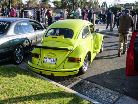
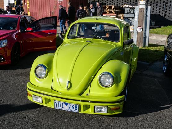
Took Harry to a little cars & coffee last Sunday. There was a huge show going on in another suburb but wasn't in the mood for the traffic and crush so went to this instead. Nice wintery morning.
🧵 (a little one)


That’s some damn good looking fritters and trout cakes you got to eat Mats. Did you pair them with anything?
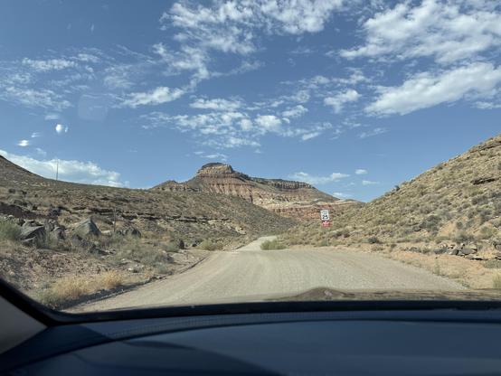
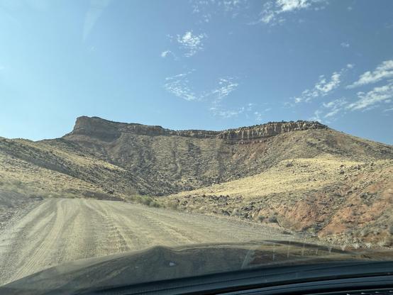
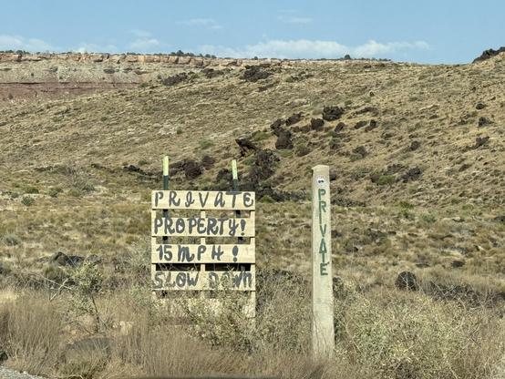
First time I came here, I thought the nav must be taking me somewhere wrong. Or to my horror picture murder.
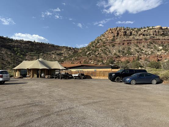
The last leg of the journey from town is like four miles of this until you finally get somewhere you definitely don’t expect to find a high-end restaurant.
If you’ll be in or near Zion National Park, Black Sage is an unexpected delight you should absolutely try.
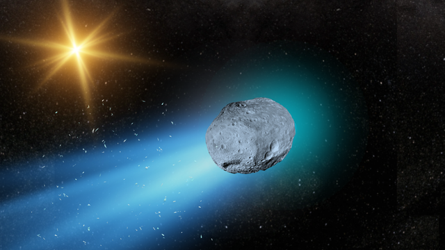
If we could live forever, imagine drifting through the endless vast sea of the cosmos for billion of years. Not staying in one place but always moving. Of all the things we would have seen.
I'm excited to learn more about this visitor.
#InterstellarComet #DeepSpace #Interstellar #Space #InterstellarObject #Comet #Galaxy #Universe #Science #3iATLAS #AncientStar
Mindreader with a super healthy libido
"Fundamentally, what we're trying to do when we have evidence here in medicine or science is prevent ourselves from confusing randomness for a signal. ... we don't want to mistake something, we think it's going on and it's not. And the challenge, particularly with any intervention is you only get to see one version of reality. You can't give someone a drug, follow them, rewind history, not give them the drug and then follow them again."
- Adam Kucharski, being interviewed by Eric Topol
https://erictopol.substack.com/p/adam-kucharski-the-uncertain-science
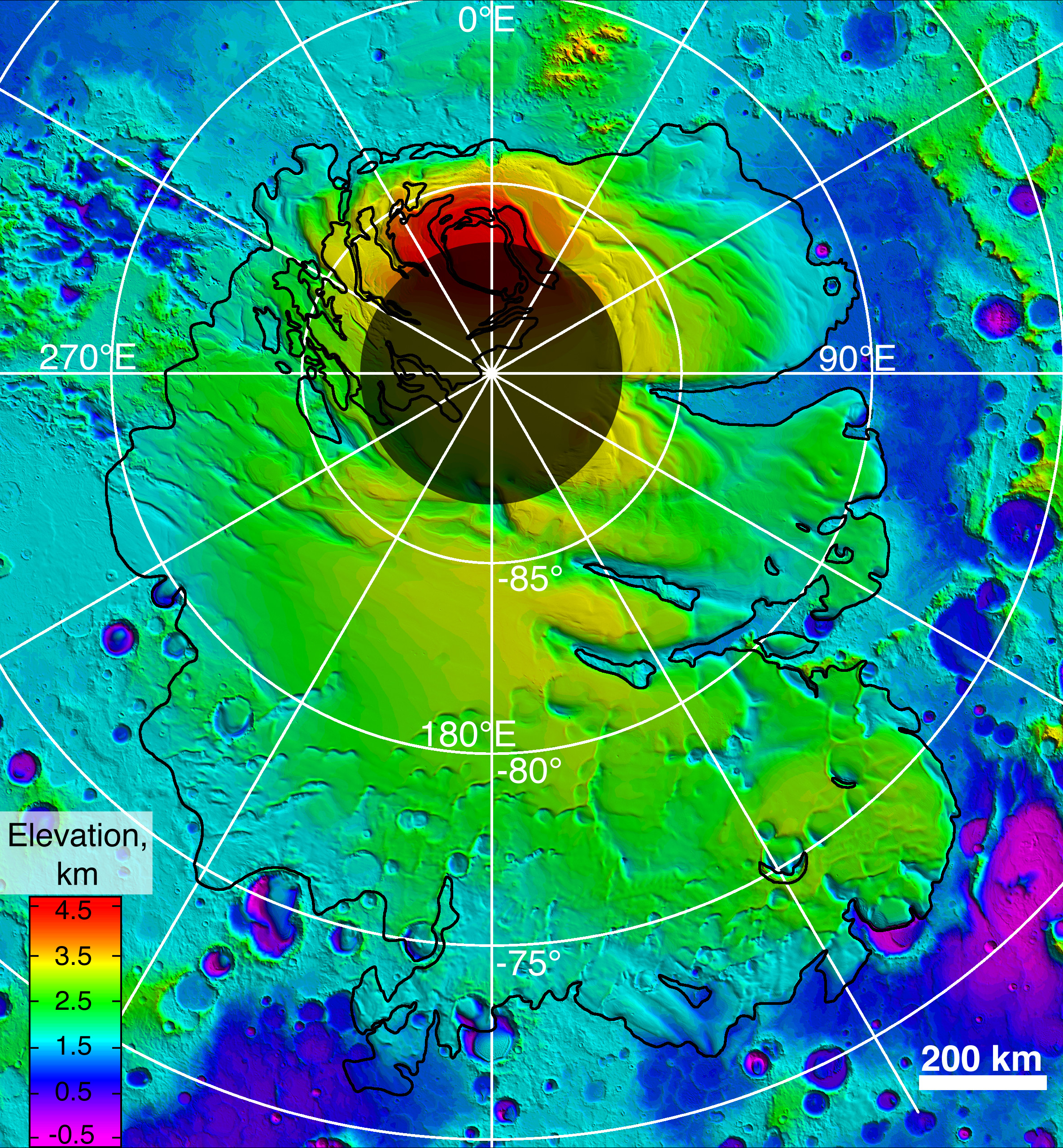
Upper surface of icy layers covering Mars' south-polar region
This map shows the topography of the south polar region of Mars. The data were collected by the Mars Orbiter Laser Altimeter (MOLA) aboard NASA’s Mars Global Surveyor orbiter between 1997 and 2001.
The elevation of the terrain is shown by colors, with purple and blue representing the lowest areas, and orange and red the highest. The total range of elevation shown is about 5 kilometres. The black line shows the boundary of the south polar layered deposits, an ice-rich geologic unit that was probed by the Mars Advanced Radar for Subsurface and Ionospheric Sounding (MARSIS) aboard the European Space Agency's Mars Express orbiter between 2005 and 2006.
The radar data indicate that the deposit is more than 3.7 kilometres thick in places, and that the material consists of nearly pure water ice, with only a small component of dust. The MARSIS team also determined that the total volume of ice in the layered deposits is equivalent to a water layer 11 metres deep, if spread evenly across the planet. The boundary of the layered deposits was mapped by scientists from the U.S. Geological Survey. The dark circle in the upper center is the area pole-ward of 87 ° south latitude, where MARSIS data cannot be collected. The image covers an area 1670 by 1800 kilometres.
CREDIT
NASA/MOLA Science Team
#space #mars #astrophotography #photography #science #astronomy #geology #topography #nature #NASA
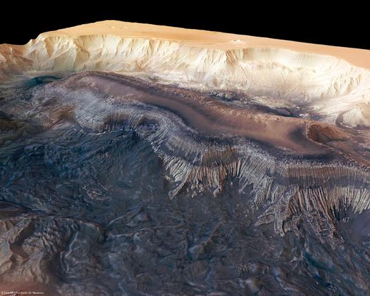
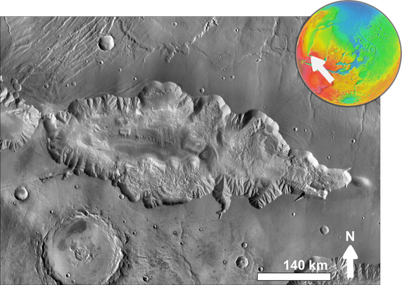
Hebes Chasma, perspective view
Perspective view of Hebes Chasma obtained by the High Resolution Stereo Camera (HRSC) on ESA’s Mars Express spacecraft.
Hebes Chasma is located at approximately 1° south and 282° east. The HRSC obtained image data on 16 September 2005 with a ground resolution of approximately 15 m/pixel.
CREDIT
ESA/DLR/FU Berlin (G. Neukum)
#space #mars #astrophotography #photography #science #astronomy #geology #topography #nature #NASA
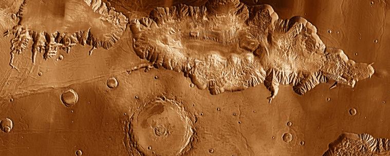
2017 May 28
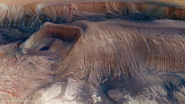
Collapse in Hebes Chasma on Mars
* Image Credit & License: ESA/DLR/FU Berlin (G. Neukum)
http://www.esa.int/
http://www.dlr.de/pf/
http://www.fu-berlin.de/
https://www.esa.int/Science_Exploration/Space_Science/People/Man_with_a_plan_An_interview_with_Gerhard_Neukum
Explanation:
What's happened in Hebes Chasma on Mars? Hebes Chasma is a depression just north of the enormous Valles Marineris canyon. Since the depression is unconnected to other surface features, it is unclear where the internal material went. Inside Hebes Chasma is Hebes Mensa, a 5 kilometer high mesa that appears to have undergone an unusual partial collapse -- a collapse that might be providing clues. The featured image, taken by ESA's robotic Mars Express spacecraft currently orbiting Mars, shows great details of the chasm and the unusual horseshoe shaped indentation in the central mesa. Material from the mesa appears to have flowed onto the floor of the chasm, while a possible dark layer appears to have pooled like ink on a downslope landing. A recent hypothesis holds that salty rock composes some lower layers in Hebes Chasma, with the salt dissolving in melted ice flows that drained through holes into an underground aquifer.
https://en.wikipedia.org/wiki/Hebes_Chasma
!>>http://geomorphology.sese.asu.edu/Papers/Adams_etal_hebes_chasma_salt_tectonics_geol.pdf
https://en.wikipedia.org/wiki/Aquifer
https://apod.nasa.gov/apod/ap170528.html
#space #mars #astrophotography #photography #science #astronomy #geology #topography #nature #NASA
From Wikipedia, the free encyclopedia
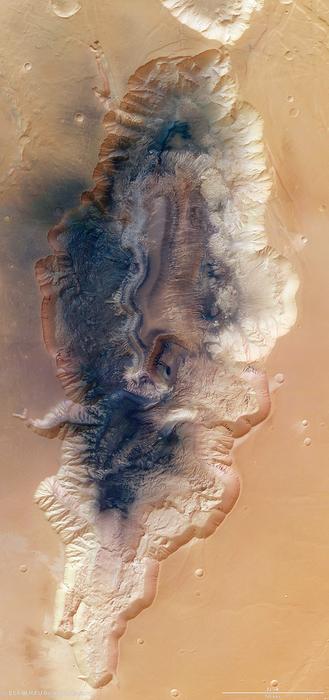
Hebes Chasma
is an isolated chasma just north of the Valles Marineris canyon system of Mars. It is centered at 1 degree southern latitude and 76 degrees western longitude, just between the Martian equator and the Valles Marineris system, just east of the Tharsis region.
Hebes Chasma is a completely closed depression in the surface of Mars, with no outflows to the nearby Echus Chasma to the west, Perrotin Crater to the southwest, or Valles Marineris to the south. Its maximum extents are approximately 320 km east to west, 130 km north to south, and 5 to 6 km in depth. At the center of the depression is Hebes Mensa, a large mesa rising some 5 km off the valley floor, nearly as high as the surrounding terrain. This central plateau makes Hebes Chasma a unique valley in Martian geography.
The word Hebes comes from Hebe, the goddess of youth, who was the daughter of Zeus and Hera. Hebe was the wife of Hercules.
The walls of Hebes Chasma weather differently than the slopes on the mesa on its floor. Also, studies of the thermal inertia suggest that the mesa and the walls of the canyon are made of different substances. Thermal inertia is how long the surface holds heat. For example, rocky areas will stay warmer than dust at night. One popular idea that explains the difference between the depression's walls and the mesa slopes is that the mesa was formed from material that accumulated in a lake.
https://en.wikipedia.org/wiki/Hebes_Chasma
#space #mars #astrophotography #photography #science #astronomy #geology #topography #nature #NASA
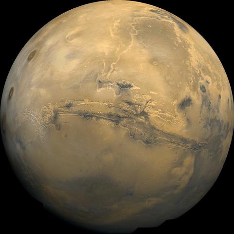
2014 May 11
Valles Marineris: The Grand Canyon of Mars
* Image Credit: Viking Project, USGS, NASA
https://nssdc.gsfc.nasa.gov/planetary/viking.html
https://www.usgs.gov/
http://www.nasa.gov/
Explanation:
The largest canyon in the Solar System cuts a wide swath across the face of Mars. Named Valles Marineris, the grand valley extends over 3,000 kilometers long, spans as much as 600 kilometers across, and delves as much as 8 kilometers deep. By comparison, the Earth's Grand Canyon in Arizona, USA is 800 kilometers long, 30 kilometers across, and 1.8 kilometers deep. The origin of the Valles Marineris remains unknown, although a leading hypothesis holds that it started as a crack billions of years ago as the planet cooled. Several geologic processes have been identified in the canyon. This mosaic was created from over 100 images of Mars taken by Viking Orbiters in the 1970s.
https://en.wikipedia.org/wiki/Valles_Marineris
https://www.windows2universe.org/mars/interior/Valles_Marineris.html
https://nssdc.gsfc.nasa.gov/photo_gallery/photogallery-mars.html
https://science.nasa.gov/mars/facts/
https://apod.nasa.gov/apod/ap140511.html
https://apod.nasa.gov/apod/ap140511.html
#space #mars #astrophotography #photography #science #astronomy #geology #topography #nature #NASA
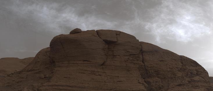
2021 June 5
The Shining Clouds of Mars
* Image Credit: NASA, JPL-Caltech, MSSS
https://www.nasa.gov/
https://www.jpl.nasa.gov/
https://www.msss.com/
Explanation:
The weathered and layered face of Mount Mercou looms in the foreground of this mosaic from the Curiosity Mars rover's Mast Camera. Made up of 21 individual images the scene was recorded just after sunset on March 19, the 3,063rd martian day of Curiosity's on going exploration of the Red Planet. In the martian twilight high altitude clouds still shine above, reflecting the light from the Sun below the local horizon like the noctilucent clouds of planet Earth. Though water ice clouds drift through the thin martian atmosphere, these wispy clouds are also at extreme altitudes and could be composed of frozen carbon dioxide, crystals of dry ice. Curiosity's Mast Cam has also imaged iridescent or mother of pearl clouds adding subtle colors to the martian sky.
https://apod.nasa.gov/apod/ap210605.html
#space #earth #atmosphere #noctilucent #astrophotography #photography #science #astronomy #physics #nature #NASA #education