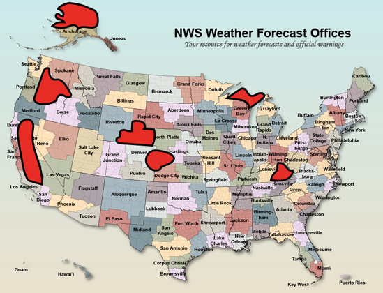
I just created a quick map depicting which portions of the United States are now (as of today) or will imminently be (by early June) without 24/7 local National Weather Service coverage (per Washington Post reporting). #CAwx #CAfire #CAwater #ORwx #AKwx #WYwx #KSwx
This map now includes much of California's (quite flammable) foothill & mountain areas ringing Central Valley (including Sierra Nevada west slope plus Coast Range east slopes/Shasta), a good chunk of Tornado Alley during tornado season, & most of Alaska's vast North Slope region.
I am certain that NWS meteorologists, hydrologists, and technicians from adjacent offices (many of which are now also understaffed) will (frantically and exhaustedly, especially during stressful extreme events) will do their very best to gap fill.
But that simply isn't going to cut it during a major extreme weather/wildfire event. Anyone arguing that NWS services in these regions (& likely others) are not already degraded is kidding themselves; present situation is one where lives could genuinely be lost due to these cuts.
@weatherwest The cuts will probably lead to fatalities: every so often, an unusual weather pattern brings intense storms originating from hurricanes off the coast of Mexico and going up the east side of the Sierra Nevada. Without advanced warning, some hikers/backpackers without adequate rain gear and counting on the typical nice weather inevitably get caught in it an perish due to hypothermia.
@weatherwest Not like much happens in the Central Valley that's vitally important to the national populace, like, I dunno, food production, or anything.
@MichaelTBacon @weatherwest
California's Central Valley really stands out as a serious problem, but the other areas all present issues as well. The chunk of Washington and Oregon affected by NWS cuts contains the Hanford Nuclear Site, where many WWII and early cold war plutonium production reactors were built, and their accompanying nuclear waste. And so on.
@weatherwest it’s gonna be an interesting summer in the PNW… and not in a good way.
@weatherwest
Crap, I was only joking when I said I’d be doing my own red flag forecasts this summer.
@weatherwest Those red zones in CA and the PNW are largely represented by GOP congresspeople. Maybe pressure can be put on them to get something done about this?
@weatherwest @not2b If not, may their houses be the ones to burn.

@weatherwest Daniel, what do the different colors on the map indicate - I didn't see a key. I am guessing colors closer to red mean less coverage and closer to green means more coverage - but don't want to assume.

Thanks for doing this!

@CuriousMagpie @weatherwest As far as I can tell, the colors are just to more easily see the individual regions, and it's just the big red blobs that mean no coverage!
Costs Pile Up As Climate Change Adds $600 Billion In Insurance Losses

Human-caused global warming has caused a third of weather-related insurance claims this century and the bill is rising fast, according to a new report.

Forbes

@Npars01 @weatherwest

Because citizens united is the Sword and the Shield!

@Npars01

Haha, that statement reminds me of the movie "Don't look up".

What most people don't realize, even if they're living the motto, things are still happening, if you know them or not. Difference is if you know them you can change them.

@weatherwest

@weatherwest That is a lot of Fire Country going without coverage...

@weatherwest

Conservatism is synonymous with hyper-Incompetence. By it's backward looking nature it can never fix a problem.

Alaska of all places, where understanding the weather is probably most crucial.

@weatherwest this isn't quite the future I was promised

@weatherwest It’s so not an accident that one of the biggest blobs of non-NWS coverage is California. (What an asshole T is.) Looking forward to California launching its own public weather service (out of the university system, probably) that’s better than what will be left of the NWS bc the better people would rather work for science than fascism.

I guess the plan is to use US Military resources to cover govt weather needs in Alaska, but that’s quite the middle finger to Alaskans. 😕

@weatherwest let's open source it.

Anyone has any home weather stations and few weather balloons?

@weatherwest I don't have much knowledge in weather forecasting, but in the event there are other WA people looking at this there's still AgWeatherNet. I don't know how much of their data they pull from NWS though, so no idea how their forecasting will be impacted.

@steph_szostek @weatherwest
If I am reading this right WSU fully owns/admins AgWeatherNet.

https://treefruit.wsu.edu/tools-resources/wsu-agweathernet/

WSU-AgWeatherNet | WSU Tree Fruit | Washington State University

@steph_szostek @weatherwest
Even so, it's nothing less than a travesty that we have an administration willing to amputate the perfectly healthy patient.

@weatherwest That's a rather large swath of the San Joaquin Valley, where a shitload of US food comes from.

I'm skipping rude jokes about eastern Washington and Oregon.
@weatherwest You know, the places in California that grow a shit ton of the countries food.