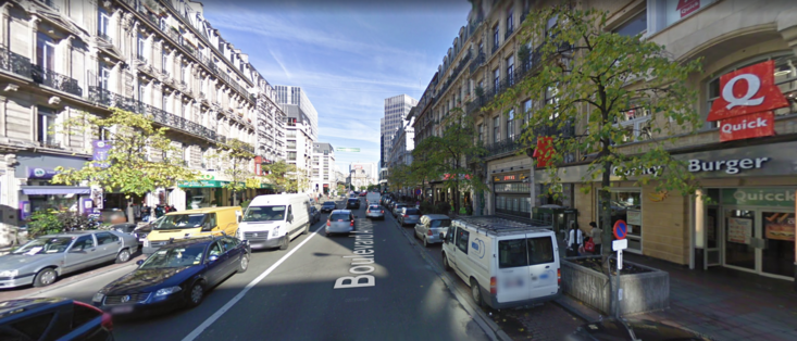
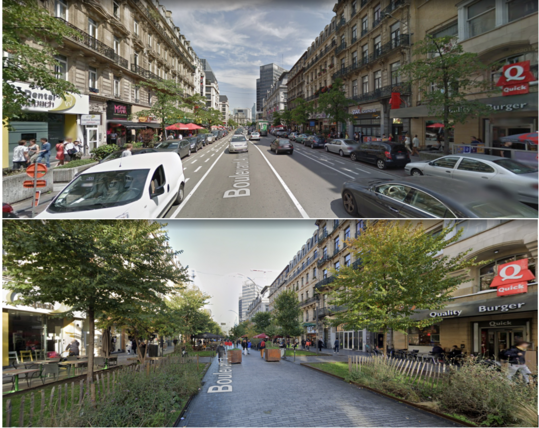
2008 v. 2023: I don’t think people realize the extent to which parked cars degrade public space.


@qag @Andres4NY
As a disabled person who sometimes needs to use a wheelchair to get around- no car means I can't get anywhere with steep hills, or miles from my home. I can't ride a bike, or walk long distances with my cane on good days- I need a car to get to the store or the doctor's office or to a concert or gathering.
I do agree that there are far too many cars and trucks and even motorcycles on many of our roads. But some of us do *need* them to be able to get to necessary services and resources. My doc isn't going to send someone to push me 10 miles to her office and then home again. But good sidewalks and bicycle/wheelchair/scooter spaces are needed, and fewer cars and trucks on the roads overall.
@SomeAnoTooter @qag @Andres4NY Did you read what I wrote at all?
Yes- I need a car to get to places miles away from my home, whether I am in my wheelchair or using my cane. I do not have a motorized wheelchair- those things are expensive as all get out- expensive to buy, expensive to repair. I can't push myself 10 miles down a highway to get to my doctors' suburban or city offices. I can't park 2 miles away and push myself or walk up steep hills to get there either.
But I also said "But good sidewalks and bicycle/wheelchair/scooter spaces are needed, and fewer cars and trucks on the roads overall.". If the spaces I need to get to have good sidewalks and bike/wheelchair paths on relatively level ground- I am all for it and will use them. But if these common areas become crowded with market stalls, tables and chairs, and crowded people- my wheelchair and lack of ability to move quickly and agilely means- I do not get to share them at all. Pretty places for you, but if I have mobility issues- I stay home?
Hey, some sass intended but are you saying that a motorized wheelchair is more expensive than a large SUV equipped for hands only driving?
A friend of mine is disabled and cannot drive. In his US city, he cannot even go to the doctor without help. Even with a motorized wheelchair, he couldn't. But in a walkable neighbourhood, he would recover most of his autonomy
Do you think cars parked on sidewalks and sign posts make for easier obstacles?
@EvilGinger013 @SomeAnoTooter @qag @Andres4NY > I need a car to get to places miles away from my home,
That's a lot more the actual problem.
Your country is using that idiotic #CarCentric development.
Turns out it's also a lot easier to build nicer accommodations for all if everything isn't ridiculously stretched out for no good reason.
@jcalais @qag Underground road tunnels are insanely expensive, and all it would do would be to move the traffic congestion (and accidents) underground.
Can’t get around the limitations of the extreme space inefficiency of cars - even a single bike lane can move more people per hour than a few lanes of road, and trams and trains so much more, it’s hardly worth comparing!
@shadyspotlight @jcalais @qag Rochester NY had an extensive streetcar/trolley/lightrail system and a subway line in the 1950s. When the streetcar system aged enough to need a refurbishment project, auto industry lobbyists bribed the city council to scrap it and replace it with busses (so that cars wouldn't have to wait behind streetcars - ignoring that busses of the time were loud, smelly and a less comfortable ride). The same thing happened in lots of other small cities at around the same time.
I live in a town of 8,000 people that's very walking accessible because it's so dang old, cars weren't invented yet when the overall layout was established. They've made it work as a destination for people who arrived from the surrounding rural areas by car, by making a few large parking lots around the edges of the town core.
I agree with underground roads not being the most practical option.
@Khada_an @shadyspotlight @jcalais @qag I lived there for several years and it was such a frustrating thing to learn.
Sadly, they also caved in and blocked the subway entrance by Dinosaur BBQ to build more "luxury mixed use housing and retail" priced too high for any city residents to actually afford. I'm pretty sure those luxury apartment buildings are some kind of tax or money laundering scheme. No one wants to pay higher rent than East Ave or Park Ave to live downtown and watch the cops arrest people at Family Dollar multiple times a day.
Fair enough! I've just seen that there are actually extensive street networks underneath Helsinki, which is a very small city. With traffic lights and roundabouts. I think they are supposed to be service roads, but the network felt pretty robust and goes straight through the city below ground. I can't help think what it woudl be like if above ground streets were just blocked off and replaced with underground routes.
Yes. That takes the will to make it happen. Banning cars and removing parking is easy; providing the services to support the unhoused and keep the streets clean and attractive - that's work.
@ifrit @qag I have come to fear sidewalk enlargements because of the damn terraces, which always take more surfacy than they are legally allowed, plus chairs placed outside the area. what's the point of increasing pedestrian spaces if in the end you have less walking space than when you had the road?
Not to mention the best friend of bar terraces: Illegal unlicensed sellers of counterfeit products taking all the space left by the terraces.
@toon @qag this is the software I used https://www.qgis.org/en/site/
Data sources for the US:
https://www.usgs.gov/the-national-map-data-delivery/gis-data-download
https://www.census.gov/geographies/mapping-files.html
https://www.arcgis.com/home/group.html?id=24838c2d95e14dd18c25e9bad55a7f82#overview (I'm not 100% sure this would work on the open source program)
Some (most?) US counties have downloadable GIS maps with things like property lines, roads, utility lines, etc. County data may be what you want for local projects.
I did a project for class on the proprietary ArcGIS mapping bike routes between specific locations with wayfinding + weighting the preferred-ness of roads based on speed limits, # of lanes and whether there is a bike lane.
I used the free version to identify land parcels of a certain size that were near either a water or a sewer connection and on a road - basically trying to identify land that would be good for building on without excessive cost.