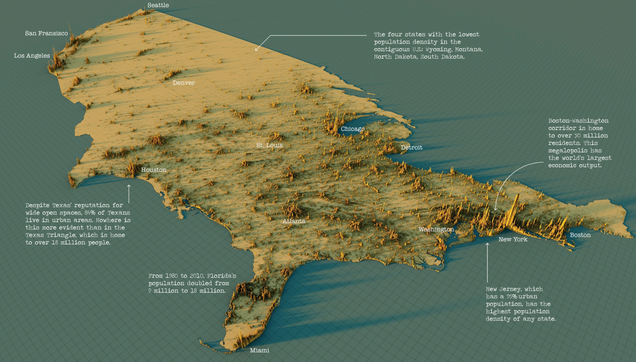
3D Map: The Worldโ€™s Largest Population Density Centers

What does population density look like on a global scale? These detailed 3D renders illustrate our biggest urban areas and highlight population trends.

Visual Capitalist
@conradhackett This map shows that Oregon is the least crowded lower-48 coastal state. But please do NOT move to Oregon. It rains 11.9 months of the year. We have venomous snakes and rabid dogs everywhere. Nothing to do--boredom is a leading cause of death. Really, DON'T move to Oregon!

@peterwalker @conradhackett
Great place for outdoorsy folks. If park has autos in parking lot just go to next one that's empty.

Everywhere in USA has venomous snakes etc. You're just trying to keep the place to yourself. Admirable. ๐Ÿ˜‰

@paul_briley @conradhackett no, no-- I mean venomous snakes are *everywhere* in Oregon. They've adapted to plumbing and can emerge from the kitchen sink, the bathtub drain, the toilet. Highly aggressive. Really, Oregon is AWFUL. Horrible.
@conradhackett *where people live in the (continental) United States.
@conradhackett for us in the US it is so powerful to see visualizations like this and then overlay over congressional and senatorial districts.
@conradhackett
great source, also for other very interesting maps. many thanks for sharing ๐Ÿ˜€
@conradhackett When I was at Bell Labs in 1970s, the Bell System had 3 types of economic/engineering planning areas:
1: rural
2: suburban/urban
3: New York City
Your visualization illustrates why...
@conradhackett This is absolutely fascinating. Love your posts Conrad.
@conradhackett astonishing and illuminating
@conradhackett really great data visualisation - makes something about the USA clear (its uneven distribution of population) that the raw data doesn't quiet convey - thanks for sharing!
@conradhackett if you fly from San Francisco east, in a few minutes the land below is basically uninhabited for a thousand miles
@conradhackett People who haven't been in the intermountain west have no idea of how empty it is!
@conradhackett
Oh hey I was able to find where I live! See that little cluster halfway between St. Louis and Kansas City? That's Columbia.
@conradhackett Neat. An interactive 3D version of this could be useful, so that you could view it from different angles and zoom levels.
@conradhackett I am fascinated by incredible population density of Java and Philippines. Any reason these islands are so much more populated than any of V the neighbouring ones?
@conradhackett Your periodic reminder that land doesn't vote...

@conradhackett

Why do visualisations always cut off the countries to which the USA is attached? (Never mind the non-continental bits of the states, and even then they usually only show Alaska and Hawaii, not the other Territories.) It contributes to geographic illiteracy, IMHO.