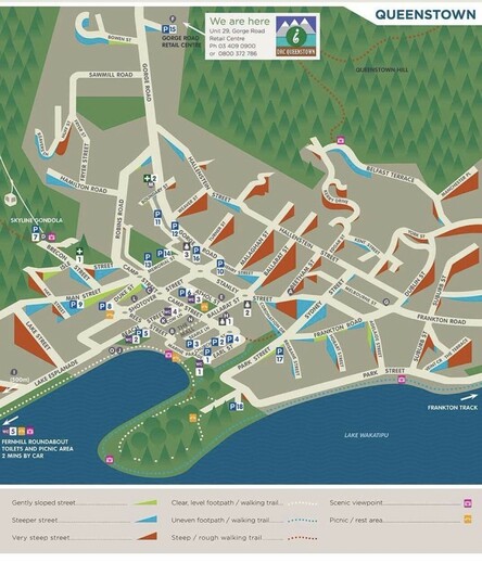
This is great! A map that shows the grades of the streets in order to help pedestrians and cyclists plan their routes (from Queenstown, New Zealand) #walking #WalkableCity #biketooter #UrbanPlanning #urbanism #geography #mapping

@JasonThorne Is this a common tool on local maps?

Never seen this implemented before, what a great idea!

@Seb @JasonThorne I've see bike maps that show grade I think once before, something like that. It's not common at all. I agree with Jason that this is a good idea.
@JasonThorne oh, that's pretty great! 🤩
@JasonThorne
I really like how the direction of the slope is represented!
I think here in Australia we would also add something about shade or canopy cover - it's such an important element in the consideration of walkability especially.
@JasonThorne wow I really wish I had this when I was there
@JasonThorne cool, also makes it way easier to find your orientation!
@JasonThorne The San Francisco Bicycle Coalition used to have a great Black and Red street map of SF where the darker the red, the steeper the street. The new version uses contour lines which I find less useful.
@JasonThorne great idea! What's with the million steep inclines though, they trying to get a pro cycling race or something?
@JasonThorne Is this a local tool? I wish we had something like that for Seattle!
@JasonThorne Oh I love this! Especially the colour-coded approach 🥰
@JasonThorne I think @cheeaun might be interested in this.
This is a really interesting way of illustrating grade on #maps. I think you’ll be interested, @uxmark Maybe in the distant future for #CyclingGuide?
@DavidTrueman Possibly. We looked at that during early research phase.

@JasonThorne We just had arguments with our transit system about the removal of bus routes from the highest hill section of the system. Although we won, it was clear they weren't taking this into consideration in decisions.

I think I'm bookmarking this for future examples--thanks!

@JasonThorne Oooh, interesting; thanks for sharing! Project at University of Washington on similar topic discussed in 2020 WSDOT webinar. Open Sidewalks project that develops accessibility maps with Anat Caspi of UW Taskar Center. Map https://www.accessmap.io/?region=wa.seattle&lon=-122.338&lat=47.607&z=14.5. Webinar archive available if you register for it: https://register.gotowebinar.com/recording/3754808426638174723
#WSDOTactive #WalkData #Accessibility #MobilityJustice #MoveEquity
AccessMap